Kechi, Kansas
| Kechi, Kansas | |
|---|---|
| City | |
 Location within Sedgwick County and Kansas | |
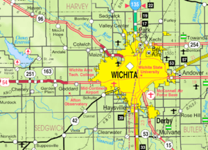 KDOT map of Sedgwick County (legend) | |
| Coordinates: 37°47′43″N 97°16′43″W / 37.79528°N 97.27861°WCoordinates: 37°47′43″N 97°16′43″W / 37.79528°N 97.27861°W | |
| Country | United States |
| State | Kansas |
| County | Sedgwick |
| Area[1] | |
| • Total | 6.02 sq mi (15.59 km2) |
| • Land | 5.97 sq mi (15.46 km2) |
| • Water | 0.05 sq mi (0.13 km2) |
| Elevation | 1,381 ft (421 m) |
| Population (2010)[2] | |
| • Total | 1,909 |
| • Estimate (2015)[3] | 1,996 |
| • Density | 320/sq mi (120/km2) |
| Time zone | Central (CST) (UTC-6) |
| • Summer (DST) | CDT (UTC-5) |
| ZIP code | 67067 |
| Area code | 316 |
| FIPS code | 20-36225 [4] |
| GNIS feature ID | 0473859 [5] |
| Website | kechiks.com |
Kechi /ˈkiːtʃaɪ/ is a city in Sedgwick County, Kansas, United States, and a suburb of Wichita. As of the 2010 census, the city population was 1,909.[6]
History
19th century
Kechi was named for the Kichai people.[7]
In 1887, the Chicago, Kansas and Nebraska Railway built a branch line north-south from Herington through Kechi to Caldwell.[8] It foreclosed in 1891 and was taken over by Chicago, Rock Island and Pacific Railway, which shut down in 1980 and reorganized as Oklahoma, Kansas and Texas Railroad, merged in 1988 with Missouri Pacific Railroad, merged in 1997 with Union Pacific Railroad. Most locals still refer to this railroad as the "Rock Island".
The first post office in Kechi was established in 1888.[9]
Geography
Kechi is located at 37°47′43″N 97°16′43″W / 37.795228°N 97.278660°W (37.795228, -97.278660).[10] According to the United States Census Bureau, the city has a total area of 6.02 square miles (15.59 km2), of which, 5.97 square miles (15.46 km2) is land and 0.05 square miles (0.13 km2) is water.[1]
Demographics
| Historical population | |||
|---|---|---|---|
| Census | Pop. | %± | |
| 1960 | 245 | — | |
| 1970 | 229 | −6.5% | |
| 1980 | 288 | 25.8% | |
| 1990 | 517 | 79.5% | |
| 2000 | 1,038 | 100.8% | |
| 2010 | 1,909 | 83.9% | |
| Est. 2015 | 1,996 | [3] | 4.6% |
| U.S. Decennial Census | |||
Kechi is part of the Wichita, KS Metropolitan Statistical Area.
2010 census
As of the census[2] of 2010, there were 1,909 people, 701 households, and 566 families residing in the city. The population density was 319.8 inhabitants per square mile (123.5/km2). There were 732 housing units at an average density of 122.6 per square mile (47.3/km2). The racial makeup of the city was 87.7% White, 5.5% African American, 0.9% Native American, 2.0% Asian, 1.2% from other races, and 2.8% from two or more races. Hispanic or Latino of any race were 3.1% of the population.
There were 701 households of which 33.2% had children under the age of 18 living with them, 73.0% were married couples living together, 5.6% had a female householder with no husband present, 2.1% had a male householder with no wife present, and 19.3% were non-families. 15.5% of all households were made up of individuals and 4.6% had someone living alone who was 65 years of age or older. The average household size was 2.72 and the average family size was 3.06.
The median age in the city was 42.6 years. 24.6% of residents were under the age of 18; 6.1% were between the ages of 18 and 24; 22.7% were from 25 to 44; 36% were from 45 to 64; and 10.7% were 65 years of age or older. The gender makeup of the city was 49.7% male and 50.3% female.
2000 census
As of the census[4] of 2000, there were 1,038 people, 354 households, and 301 families residing in the city. The population density was 785.0 people per square mile (303.6/km2). There were 370 housing units at an average density of 279.8 per square mile (108.2/km2). The racial makeup of the city was 87.67% White, 7.71% African American, 0.67% Native American, 0.58% Asian, 0.10% Pacific Islander, 0.19% from other races, and 3.08% from two or more races. Hispanic or Latino of any race were 2.12% of the population.
There were 354 households out of which 45.8% had children under the age of 18 living with them, 77.4% were married couples living together, 5.4% had a female householder with no husband present, and 14.7% were non-families. 12.1% of all households were made up of individuals and 2.3% had someone living alone who was 65 years of age or older. The average household size was 2.93 and the average family size was 3.19.
In the city the population was spread out with 31.1% under the age of 18, 6.3% from 18 to 24, 35.8% from 25 to 44, 22.2% from 45 to 64, and 4.6% who were 65 years of age or older. The median age was 33 years. For every 100 females there were 100.0 males. For every 100 females age 18 and over, there were 98.1 males.
The median income for a household in the city was $61,333, and the median income for a family was $62,212. Males had a median income of $43,393 versus $28,077 for females. The per capita income for the city was $22,444. About 2.5% of families and 2.5% of the population were below the poverty line, including 4.4% of those under age 18 and 4.7% of those age 65 or over.
References
- 1 2 "US Gazetteer files 2010". United States Census Bureau. Retrieved 2012-07-06.
- 1 2 "American FactFinder". United States Census Bureau. Retrieved 2012-07-06.
- 1 2 "Annual Estimates of the Resident Population for Incorporated Places: April 1, 2010 to July 1, 2015". Retrieved July 2, 2016.
- 1 2 "American FactFinder". United States Census Bureau. Retrieved 2008-01-31.
- ↑ "US Board on Geographic Names". United States Geological Survey. 2007-10-25. Retrieved 2008-01-31.
- ↑ "2010 City Population and Housing Occupancy Status". U.S. Census Bureau. Retrieved March 6, 2011.
- ↑ "City History". City of Kechi, Kansas. Retrieved 12 June 2014.
- ↑ Rock Island Rail History
- ↑ "Kansas Post Offices, 1828-1961". Kansas Historical Society. Archived from the original on October 9, 2013. Retrieved 10 June 2014.
- ↑ "US Gazetteer files: 2010, 2000, and 1990". United States Census Bureau. 2011-02-12. Retrieved 2011-04-23.
External links
| Wikimedia Commons has media related to Kechi, Kansas. |
- City
- Schools
- Maps
- Kechi City Map, KDOT
Municipalities and communities of Sedgwick County, Kansas, United States | ||
|---|---|---|
| Cities | 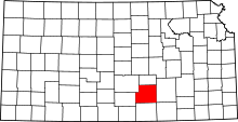 | |
| CDPs | ||
| Unincorporated communities | ||
| Townships | ||
| Footnotes | ‡This populated place also has portions in an adjacent county or counties | |
