Highpoint, Ohio
| Highpoint | |
|---|---|
| Census-designated place (CDP) & Unincorporated community | |
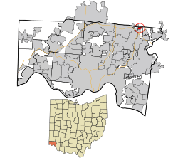 Location in Hamilton County and the state of Ohio. | |
| Coordinates: 39°17′18″N 84°21′01″W / 39.28833°N 84.35028°WCoordinates: 39°17′18″N 84°21′01″W / 39.28833°N 84.35028°W | |
| Country | United States |
| State | Ohio |
| County | Hamilton |
| Area[1] | |
| • Total | 0.344 sq mi (0.89 km2) |
| • Land | 0.344 sq mi (0.89 km2) |
| • Water | 0 sq mi (0 km2) |
| Elevation | 873 ft (266 m) |
| Population (2010)[2] | |
| • Total | 1,503 |
| • Density | 4,400/sq mi (1,700/km2) |
| Time zone | Eastern (EST) (UTC-5) |
| • Summer (DST) | EDT (UTC-4) |
| Area code(s) | 513 |
| GNIS feature ID | 1056329[3] |
Highpoint (also known as High Point) is an unincorporated community and census-designated place (CDP) in Sycamore Township, Hamilton County, Ohio, United States, located about 20 miles north of Cincinnati, Ohio. As of the 2010 census, its population was 1,503.[2] Highpoint was founded in the 19th century. It was named Highpoint because, at least at one time, it was the highest point in Hamilton County, a distinction now held by the Rumpke Sanitary Landfill.
While the Tri County Mall and shopping area is nine miles west, Highpoint is sometimes called the real tri county because the three counties; Hamilton, Butler and Warren all meet right there.
References
- ↑ "US Gazetteer files: 2010, 2000, and 1990". United States Census Bureau. 2011-02-12. Retrieved 2011-04-23.
- 1 2 "American FactFinder". United States Census Bureau. Retrieved 2011-05-14.
- ↑ "Highpoint". Geographic Names Information System. United States Geological Survey.
External links
Municipalities and communities of Hamilton County, Ohio, United States | ||
|---|---|---|
| Cities | 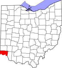 | |
| Villages | ||
| Townships | ||
| CDPs |
| |
| Other unincorporated communities | ||
| Footnotes | ‡This populated place also has portions in an adjacent county or counties | |
This article is issued from Wikipedia - version of the 9/29/2015. The text is available under the Creative Commons Attribution/Share Alike but additional terms may apply for the media files.