Concorde Hills, Ohio
| Concorde Hills, Ohio | |
|---|---|
| Census-designated place | |
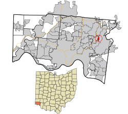 Location in Hamilton County and the state of Ohio. | |
| Coordinates: 39°12′38″N 84°21′27″W / 39.21056°N 84.35750°WCoordinates: 39°12′38″N 84°21′27″W / 39.21056°N 84.35750°W | |
| Country | United States |
| State | Ohio |
| County | Hamilton |
| Area | |
| • Total | 0.4 sq mi (1.0 km2) |
| • Land | 0.4 sq mi (1.0 km2) |
| • Water | 0 sq mi (0 km2) |
| Elevation[1] | 800 ft (200 m) |
| Population (2010) | |
| • Total | 663 |
| • Density | 1,700/sq mi (660/km2) |
| Time zone | Eastern (EST) (UTC-5) |
| • Summer (DST) | EDT (UTC-4) |
| FIPS code | 39-18244[2] |
Concorde Hills is a census-designated place (CDP) in Sycamore Township, Hamilton County, Ohio, United States. The population was 663 at the 2010 census.[3]
Geography
Concorde Hills is located at 39°12′38″N 84°21′27″W / 39.21056°N 84.35750°W,[4] just east of Kenwood and 14 miles (23 km) northeast of Cincinnati. It is bordered by The Village of Indian Hill to the east and the city of Madeira to the south.
According to the United States Census Bureau, the CDP has a total area of 0.39 square miles (1.0 km2), all land.[3]
References
- ↑ "US Board on Geographic Names". United States Geological Survey. 2007-10-25. Retrieved 2008-01-31.
- ↑ "American FactFinder". United States Census Bureau. Archived from the original on 2013-09-11. Retrieved 2008-01-31.
- 1 2 "Geographic Identifiers: 2010 Demographic Profile Data (G001): Concorde Hills CDP, Ohio". U.S. Census Bureau, American Factfinder. Retrieved November 13, 2012.
- ↑ "US Gazetteer files: 2010, 2000, and 1990". United States Census Bureau. 2011-02-12. Retrieved 2011-04-23.
Municipalities and communities of Hamilton County, Ohio, United States | ||
|---|---|---|
| Cities | 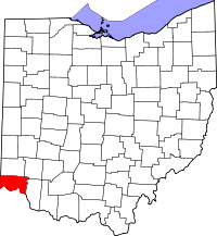 | |
| Villages | ||
| Townships | ||
| CDPs |
| |
| Other unincorporated communities | ||
| Footnotes | ‡This populated place also has portions in an adjacent county or counties | |
This article is issued from Wikipedia - version of the 11/29/2016. The text is available under the Creative Commons Attribution/Share Alike but additional terms may apply for the media files.
