Glen Helen, Isle of Man
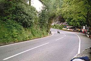
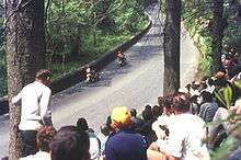
Glen Helen (in Manx: Glion Lammal, formerly Glen Rhenass)[1] an area of wooded valleys, is known for the sweeping left-bend and uphill exit towards Creg Willey's Hill on the Snaefell Mountain Course used for the Isle of Man TT Races.
One of a series of Manx National Glens, it is situated on the primary A3 Castletown to Ramsey road in the parish of German, between the 9th and 10th Milestone road-side markers measured from the startline at the TT Grandstand. Glen Helen is preceded by Black Dub and followed by Sarah's Cottage.
The glen itself with picturesque walks can be accessed from the car park adjacent to the bend on the main A3 road.[2]
History
The glen was developed in the 1860s by a consortium of Manx businessmen interested in arboriculture. They carried out extensive planting of trees and ornamental shrubs, laid paths, constructed river bridges and opened the site to the public in 1867. The attractive name Glen Helen was probably chosen from Greek myth to reflect the beauty of the location.[3]
Today a variety of mature and impressive trees including sequoia, thuja, spruces, Douglas fir, oak, sycamore and beech can be seen. Paths traverse the glen along the rivers Neb and Blaber. Three-quarters of a mile into the glen is the dramatic Rhenass Waterfall.[4]
 River Neb with footbridge
 A tree at the mouth of the glen planted in 1933 by aviator Amy Johnson
 The Rhenass Falls at the top end of the glen
Racing
Glen Helen was part of the Highland Course and Four Inch Course used for the Gordon Bennett Trial and Tourist Trophy car races held between 1904 and 1922. In 1905, Glen Helen was part of the course used for International Motor Cycle Cup Races. It was then part of the St. John's Short Course used between 1907 and 1910 for the TT races. Thereafter, the Four Inch Course was used, now known as the Mountain Course.
Sources
- ↑ Place Names of the Isle of Man by John Kneen MA pp395 (1970) Yn Cheshaght Ghailckagh The Scolar Press
- ↑ Glen Helen at IoM guide. Retrieved 2015-06-27
- ↑ Isle of Man Department of Environment, Food and Agriculture
- ↑ Isle of Man Department of Environment, Food and Agriculture
External links
- Glen Helen - Isle of Man Department of Environment, Food and Agriculture
- Competitor Guide Sections Black Dub to Handleys Corner with Steve Hislop, 11 times TT winner
- TT Spectator Guide Section Ballig to Sarah's Cottage
- Map of course
| Wikimedia Commons has media related to Glen Helen. |
Coordinates: 54°13′33″N 4°37′02″W / 54.22583°N 4.61722°W