Cronk-ny-Mona

Cronk-ny-Mona (Manx: Hill of the turbary)[1] is situated between the 36th and 37th Milestone road-side markers used for the Snaefell Mountain Course, being on the primary A18 Mountain Road at the road junction with the A21 Johnny Watterson('s) Lane and the tertiary C10 Scholag Road in the parish of Onchan in the Isle of Man.
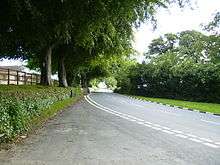
Cronk-ny-Mona, a steep hill topping-out to a sweeping left hand bend located after Hillberry corner on the TT course, leads from agricultural farmland and passes through sympathetically-landscaped modern residential developments on either side, continuing the traditional rural theme and demarking the outer-margins of Douglas town. The hill interrupts the descent from Snaefell Mountain, which resumes at the next TT vantage point, the right turn at Signpost Corner, starting the run down through the outskirts of Douglas to the finish line at TT Grandstand.
History
Cronk-ny-Mona was part of the Highland Course and Four Inch Course used for the Gordon Bennett Trial and Tourist Trophy car races between 1904 and 1922. The Cronk-ny-Mona road junction is part of the Mountain Course used since 1911 for the Isle of Man TT and from 1923 for the Manx Grand Prix races.
For the 1920 Isle of Man TT races, changes were made to the Mountain Course and competitors turned left at Cronk-ny-Mona following the primary A18 Mountain Road to Governor's Bridge with a new start/finish line on Glencrutchery Road which lengthened the course to 37¾ miles. To facilitate racing on the Clypse Course for the 1954 Isle of Man TT races, during the winter of 1953/54 road widening occurred on the Mountain Course at Creg-ny-Baa along with Signpost Corner, the section of road from Hillberry corner to Cronk-ny-Mona, and the approach to Governor's Bridge.[2]
Sources
External links
- Competitor Guide Keppel Gate to Cronk ny Mona with Steve Hislop, 11 times TT winner
- TT Spectator Guide Section Creg-ny-Baa to Governor's Bridge
- Map of course
Coordinates: 54°11′00″N 4°28′33″W / 54.18333°N 4.47583°W