Dry Valley, Nevada
| Dry Valley, Nevada | |
|---|---|
| Census-designated place | |
 Dry Valley Location within the state of Nevada | |
| Coordinates: 37°53′10″N 114°18′18″W / 37.88611°N 114.30500°WCoordinates: 37°53′10″N 114°18′18″W / 37.88611°N 114.30500°W | |
| Country | United States |
| State | Nevada |
| County | Lincoln |
| Area | |
| • Total | 3.8 sq mi (9.8 km2) |
| • Land | 3.8 sq mi (9.8 km2) |
| • Water | 0 sq mi (0 km2) |
| Elevation | 5,154 ft (1,571 m) |
| Population (2010) | |
| • Total | 78 |
| • Density | 21/sq mi (8.0/km2) |
| Time zone | Pacific (PST) (UTC-8) |
| • Summer (DST) | PDT (UTC-7) |
| FIPS code | 32-19800 |
Dry Valley is a census-designated place in Lincoln County, Nevada, United States. As of the 2010 census it had a population of 78.[1]
Geography
The CDP is located in Dry Valley, a flat basin through which Meadow Valley Wash flows before it exits to the southwest into Condor Canyon. The CDP is located 9 miles (14 km) east of Pioche and is reached by Echo Dam Road, which continues east another 3 miles (5 km) to Echo Canyon State Park.
According to the U.S. Census Bureau, the Dry Valley CDP has an area of 3.8 square miles (9.8 km2), all of it land.[1]
References
- 1 2 "Geographic Identifiers: 2010 Demographic Profile Data (G001): Dry Valley CDP, Nevada". U.S. Census Bureau, American Factfinder. Retrieved January 25, 2013.
Municipalities and communities of Lincoln County, Nevada, United States | ||
|---|---|---|
| Cities | 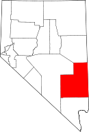 | |
| CDPs | ||
| Other unincorporated communities | ||
| Ghost towns | ||
| Footnotes | ‡This populated place also has portions in an adjacent county or counties | |
This article is issued from Wikipedia - version of the 11/21/2013. The text is available under the Creative Commons Attribution/Share Alike but additional terms may apply for the media files.