Beaverdam, Nevada
| Beaverdam, Nevada | |
|---|---|
| Census-designated place | |
 Beaverdam Location within the state of Nevada | |
| Coordinates: 37°40′52″N 114°27′8″W / 37.68111°N 114.45222°WCoordinates: 37°40′52″N 114°27′8″W / 37.68111°N 114.45222°W | |
| Country | United States |
| State | Nevada |
| County | Lincoln |
| Area | |
| • Total | 3.9 sq mi (10.0 km2) |
| • Land | 3.9 sq mi (10.0 km2) |
| • Water | 0 sq mi (0 km2) |
| Elevation | 4,600 ft (1,400 m) |
| Population (2010) | |
| • Total | 44 |
| • Density | 11/sq mi (4.4/km2) |
| Time zone | Pacific (PST) (UTC-8) |
| • Summer (DST) | PDT (UTC-7) |
| FIPS code | 32-05125 |
Beaverdam is a census-designated place in Lincoln County, Nevada, United States. As of the 2010 census it had a population of 44.[1]
Geography
Beaverdam is located in the Meadow Valley, east of U.S. Route 93, 9 miles (14 km) south of Panaca and 6 miles (10 km) north of Caliente.
According to the U.S. Census Bureau, the Beaverdam CDP has an area of 3.9 square miles (10.0 km2), all of it land.[1]
References
- 1 2 "Geographic Identifiers: 2010 Demographic Profile Data (G001): Beaverdam CDP, Nevada". U.S. Census Bureau, American Factfinder. Retrieved January 25, 2013.
Municipalities and communities of Lincoln County, Nevada, United States | ||
|---|---|---|
| Cities | 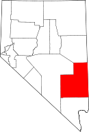 | |
| CDPs | ||
| Other unincorporated communities | ||
| Ghost towns | ||
| Footnotes | ‡This populated place also has portions in an adjacent county or counties | |
This article is issued from Wikipedia - version of the 11/21/2013. The text is available under the Creative Commons Attribution/Share Alike but additional terms may apply for the media files.