Elgin, Nevada
| Elgin | |
|---|---|
| Ghost town | |
 Elgin  Elgin Location within the state of Nevada | |
| Coordinates: 37°21′07″N 114°32′09″W / 37.35194°N 114.53583°WCoordinates: 37°21′07″N 114°32′09″W / 37.35194°N 114.53583°W | |
| Country | United States |
| State | Nevada |
| County | Lincoln |
| Elevation | 3,410 ft (1,040 m) |
| Population (2000) | |
| • Total | 14 |
| Time zone | Pacific (PST) (UTC-8) |
| • Summer (DST) | PDT (UTC-7) |
Elgin /ˈɛldʒᵻn/ is a ghost town located between Caliente and Carp, Nevada on the eastern banks of the Meadow Valley Wash off of Nevada State Route 317.
A former railroad town, it is now the location of the Elgin Schoolhouse State Historic Site, a one-room schoolhouse museum. There is an apple orchard nearby.
As of May 2008, the State Historic Site is permanently closed due to the damage to the only road leading to the site, Nevada State Route 317, caused by flooding.
External links
Municipalities and communities of Lincoln County, Nevada, United States | ||
|---|---|---|
| Cities | 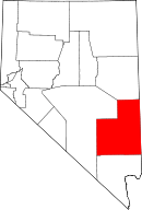 | |
| CDPs | ||
| Other unincorporated communities | ||
| Ghost towns | ||
| Footnotes | ‡This populated place also has portions in an adjacent county or counties | |
This article is issued from Wikipedia - version of the 12/1/2016. The text is available under the Creative Commons Attribution/Share Alike but additional terms may apply for the media files.