Drift, Kentucky
| Drift, Kentucky | |
|---|---|
| Unincorporated community | |
 Drift  Drift Location within the state of Kentucky | |
| Coordinates: 37°28′49″N 82°44′52″W / 37.48028°N 82.74778°WCoordinates: 37°28′49″N 82°44′52″W / 37.48028°N 82.74778°W | |
| Country | United States |
| State | Kentucky |
| County | Floyd |
| Population (2000) | |
| • Total | 569 |
| Time zone | Eastern (EST) (UTC-5) |
| • Summer (DST) | EDT (UTC-4) |
| ZIP codes | 41619 |
| Area code(s) | 606 |
| GNIS feature ID | 491113 |
Drift, Kentucky is an unincorporated community and coal town in Floyd County, Kentucky, United States. As of the census of 2000, there were 569 people residing in the ZIP Code Tabulation Area (ZCTA) for Drift's ZIP code (41619).[1]
Drift is located at 37°28′49″N 82°44′52″W / 37.48028°N 82.74778°W (37.4803778, -82.7476587) at an elevation of 715 feet (218 m).[2]
A post office was established in the community in 1909. The origins of the name Drift are unclear: it may have been named for a local mine or for driftwood found in a nearby creek.[3]
References
- ↑ American Factfinder Retrieved on 2010-04-03
- ↑ U.S. Geological Survey Geographic Names Information System: Drift, Kentucky Retrieved on 2010-04-03
- ↑ Rennick, Robert M. (1987). Kentucky Place Names. University Press of Kentucky. p. 85. Retrieved 2013-04-28.
Municipalities and communities of Floyd County, Kentucky, United States | ||
|---|---|---|
| Cities | 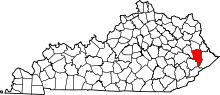 | |
| CDPs | ||
| Other unincorporated communities |
| |
This article is issued from Wikipedia - version of the 10/11/2016. The text is available under the Creative Commons Attribution/Share Alike but additional terms may apply for the media files.