Cilgerran
| Cilgerran | |
 View over Cilgerran town |
|
 Cilgerran |
|
| Population | 1,507 (2011)[1] |
|---|---|
| OS grid reference | SN195427 |
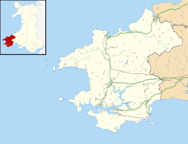
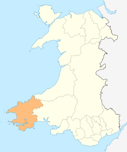
| Principal area | Pembrokeshire |
| Ceremonial county | Dyfed |
| Country | Wales |
| Sovereign state | United Kingdom |
| Post town | CILGERRAN |
| Postcode district | SA43 |
| Dialling code | 01239 |
| Police | Dyfed-Powys |
| Fire | Mid and West Wales |
| Ambulance | Welsh |
| EU Parliament | Wales |
| UK Parliament | Preseli Pembrokeshire |
|
|
Coordinates: 52°03′12″N 4°38′02″W / 52.05322°N 4.63396°W
Cilgerran (previously Kilgerran or Cil-Garon) is a parish, community and formerly incorporated market town situated on the River Teifi in north Pembrokeshire, Wales. The town gives its name to the Hundred of Cilgerran[2] and was previously the headquarters of the commote of Emlyn is Cuch.
Among Cilgerran's attractions are Cilgerran Castle and annual coracle races. Kilgerran Halt was a stop on the former Whitland and Cardigan Railway. There are a number of listed buildings, including the parish church.
Nearby are the hamlets of Llwyncelyn, Rhoshill, Cnwce, Pen-y-bryn, Carreg-wen and Pontrhydyceirt, and the villages of Llechryd and Boncath.
Geography
Cilgerran lies 50 metres (160 ft) above sea level close to the southern bank of the River Teifi as it flows north-west towards its estuary beyond Cardigan. The stream Afon Plysgog which rises on nearby Rhoshill runs under the road to the west of Cilgerran on its way to join the Teifi to the north of the town. A mixture of woodland and pasture surrounds the town, which is strung out along a fairly level C-class road in an east-west orientation connecting with the A478 at Pen-y-bryn to the west and the A484 at Llechryd, Ceredigion, to the east.
History

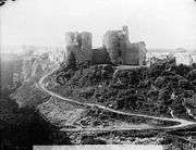
Cilgerran Castle, strategically built in 1100 at "Cenarth Bychan", high above the River Teifi, is the castle from which Owain of Powys is said to have abducted Nest in 1109. Originally in Cantref Emlyn (Emlyn Is-Cych), Cilgerran came under Norman control with the building of the castle, from where the Lordship of Cilgerran was administered. The Welsh under the Lord Rhys regained control from 1164-5 (the date of the first recording of the name "Cilgerran"[3]) to 1223. By 1204 the town was beginning to grow, with 22 taxpayers recorded in 1292.[4]
After 1223 William Marshall, Earl of Pembroke took control, and his heirs ruled until the lordship passed to the crown in the late 15th century. The Hundred of Cilgerran was established in 1536. It was a marcher borough; Owen, Lord of Kemes, described it in 1603 as one of five Pembrokeshire boroughs overseen by a portreeve.[5] Although the town remained small it was considered one of the main market centres in Pembrokeshire in the early 17th century, with mainly Welsh demographics.
.jpg)
The principal occupations throughout Cilgerran's history were farming, salmon fishing and slate quarrying. Most slate was quarried in the Teifi gorge, and many of the houses in the town were built from this stone. The town was renowned for the quality of the slate that was mined there and exported through the port at Cardigan. The industry peaked in the late 19th century, its continuance until that time supported by the coming of the railway in 1869. The town's market ended in the early 20th century, there was no further quarrying after 1936 and the castle had been allowed to become a ruin since the 16th century, partly as a result of nearby quarrying, so the town reverted to being termed a village, but still retained town status with a town council.[4]
Amenities
Worship
.jpg)
The church of St Llawddog is a grade II* listed building (Cadw I.D. 11972). The church's tower is mediaeval and the remainder, in decorated Gothic style, dates from 1855. The font and pulpit are carved Bath stone.[6]
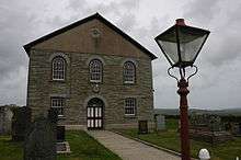
Penual Baptist Chapel (a Grade II listed building)[7] is on the main street, while Tyrhos Congregational Chapel (Grade II)[8] is on the road linking Cilgerran and the hamlet of Rhoshill. Babell Calvinist Methodist Chapel dates from about 1763 and closed in 2011.
Education
Cilgerran County Primary School educates 139 (in 2013) children from nursery to 11 years old and serves several surrounding villages. Pupils are taught in English and Welsh with the aim of bilingualism by the age of 11.[9]
Public houses
The Cardiff Arms (19th century)[10] and Pendre Inn (18th century or earlier)[11] are both Grade II listed buildings; the Masons Arms (known locally as the Ramp Inn) is in Cnwce, a settlement to the east of Cilgerran.
Businesses
Cilgerran has a part-time post office, a garage/petrol station and general stores. In and around the town are a number of small businesses including a pet food store.
Transport
Since the closing of the Whitland and Cardigan Railway in 1962, the only public transport serving Cilgerran is the local bus service.
Attractions
With much of Cilgerran Castle in ruins, its picturesque nature and setting has attracted many artists including Turner.

The churchyard contains a megalithic standing stone or Ogham stone upon which Ogham writing can still be seen.
The annual coracle races on the River Teifi were first held in 1950 and attract competitors from all over the world. The river flows slowly through a wooded gorge below the castle making it attractive for canoeists and kayakers.
Located in the river valley between Cilgerran and Cardigan is The Welsh Wildlife Centre and Teifi Marsh, a haven for wildlife and popular with visitors of all ages. The trackbed of the former railway is now a footway and cycle path connecting the two towns.[12] A rare visit by a white stork was photographed in April 2016.[13]
Rhosygilwen estate, near Rhoshill, is a venue for concerts and exhibitions, attracting international artists and musicians under the banner of Project Rhosygilwen, run by Dr Glen Peters.[14] The estate is home to the first utility-scale solar park in west Wales, constructed in 2011 and generating enough electricity to power 300 homes.[15]
Notable people
In the churchyard is the burial site and memorial to William Edmond Logan of Mount Logan, Canada fame. Logan was the first director of Geological Survey of Canada and mapped the coal mines of South Wales. The memorial was erected in the centenary of his death.
Geographer Thomas Frederick Colby was brought up at Rhosygilwen mansion between Cilgerran and Rhoshill.
Liberal politician and patent lawyer Rhys Gerran Lloyd, whose middle name was inspired by the village where his father had a home, took his Life Peerage title (in anglicised form) as Baron Lloyd of Kilgerran in 1973.
Population and governance
The census population of the parish of Cilgerran was: 854 (1801): 1266 (1851): 1,033 (1901): 815 (1951): 703 (1981). The percentage of Welsh speakers was: 96 (1891): 94 (1931): 78 (1971). The population in 2001 was 1,931, with 53% Welsh speakers.
The community of Cilgerran includes the parishes of Bridell and Llantood, and had a population of 1453 in 2001, increasing to 2,058 in the 2011 Census.[16] The village has its own elected community council and gives its name to an electoral ward of The electoral ward of Dinas Cross covers the communities of Dinas Cross, Cwm Gwaun and Puncheston.

Cilgerran has its own elected town council and gives its name to an electoral ward of Pembrokeshire County Council. The electoral ward of Cilgerran covers the communities of Cilgerran and Manordeifi. Since reorganisation in 1995 the ward has been held by independent councillors. The current member is John Davies, former leader of the authority.
References
- ↑ "Community population 2011". Retrieved 17 April 2015.
- ↑ "GENUKI: Cilgerran". Retrieved 10 June 2014.
- ↑ "CADW: Cilgerran Castle". Retrieved 2014. Check date values in:
|access-date=(help) - 1 2 "Dyfed Archaeological Trust: Cilgerran (with original citations)". Retrieved 10 June 2014.
- ↑ Owen, George (1892). The Description of Penbrokshire. Henry Owen (Ed), London.
- ↑ "Church of St. Llawddog,church Street (S Side), Cilgerran". British Listed Buildings. Retrieved 29 December 2013.
- ↑ "Penuel Baptist Chapel". Retrieved 26 May 2014.
- ↑ "Tyrhos Chapel (British Listed Buildings)". Retrieved 26 May 2014.
- ↑ "Cilgerran V.C.P. School - Estyn". Retrieved 26 May 2014.
- ↑ "The Cardiff Arms (British Listed Buildings)". Retrieved 26 May 2014.
- ↑ "The Pendre Inn (British Listed Buildings)". Retrieved 26 May 2014.
- ↑ "Welsh Wildlife Centre and Teifi Marsh". Retrieved 26 May 2014.
- ↑ "Rare stork spotted in Cilgerran". Pembrokeshire Herald. 28 April 2016. Retrieved 3 May 2016.
- ↑ "Dr Glen Peters - Profile". The Guardian. Retrieved 16 June 2014.
- ↑ "Wales' first solar park fires up in Pembrokeshire". BBC Wales. 8 July 2011. Retrieved 16 June 2014.
- ↑ "Ward population 2011". Retrieved 17 April 2015.
| Wikimedia Commons has media related to Cilgerran. |
External links
- Information about Cilgerran
- Photographs of Cilgerran and the surrounding area on Geograph
- A Vision of Britain through Time: Cilgerran (historical background)
- Cilgerran (Visit Pembrokeshire); local information
| Preceding station | Historical railways | Following station | ||
|---|---|---|---|---|
| Boncath | Great Western Railway Whitland & Cardigan Railway |
Cardigan | ||