Castlereagh, New South Wales
| Castlereagh Sydney, New South Wales | |||||||||||||
|---|---|---|---|---|---|---|---|---|---|---|---|---|---|
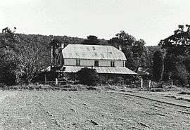 Hadley Park | |||||||||||||
| Coordinates | 33°40′19″S 150°40′42″E / 33.6719°S 150.6784°ECoordinates: 33°40′19″S 150°40′42″E / 33.6719°S 150.6784°E | ||||||||||||
| Population | 1,055 (2011 census)[1] | ||||||||||||
| Established | 1810 | ||||||||||||
| Postcode(s) | 2749 | ||||||||||||
| Location | 67 km (42 mi) west of Sydney CBD | ||||||||||||
| LGA(s) | City of Penrith | ||||||||||||
| State electorate(s) | |||||||||||||
| Federal Division(s) | Lindsay | ||||||||||||
| |||||||||||||
Castlereagh is a suburb of Sydney, in the state of New South Wales, Australia. Castlereagh is 67 kilometres west of the Sydney central business district, in the local government area of the City of Penrith and is part of the Greater Western Sydney region.
History
The suburb is one of the most historic sites in Australia's history, being one of the five Macquarie towns officially proclaimed on 6 December 1810.[2] Governor Lachlan Macquarie recorded the following in his journal "the Township for the Evan or Nepean District I have named Castlereagh in honor (sic) of Lord Viscount Castlereagh",[2] Secretary of State for War and the Colonies 1805–1806. He, in turn, was named after Castlereagh in Northern Ireland. The official Government and General Order issued from Government House, Sydney was dated 15 December 1810.
The earliest known European development was the building of Hadley Park, between what is now Castlereagh Road and the Nepean River. Charles Hadley was given a grant in 1803, and his house, Hadley Park, was built c.1806. It still stands, largely intact. It has been said that it is difficult to overestimate the significance of this building. It was one of the earliest buildings in the colony and is "probably unique in its condition and setting". It is heritage-listed.[3]
Circa 1822, Nepean Park, also situated on Castlereagh Road, was built by convict labour for John Single. A notable two-storey farmhouse in the Georgian style, it was acquired by the Dixon family in 1934. It is heritage-listed at state and federal level.[4][5]
Castlereagh Post Office opened on 1 April 1857 and closed in 1967.[6]
After two hundred years, the rich river flats still provide for a thriving agricultural industry along the Nepean River. Many of Penrith district's pioneering families had originated from Castlereagh. The suburb's historical importance is reflected in its many surviving farmhouses, outbuildings, churches and cemeteries.
Demographics
According to the 2011 census, there were 1,055 residents in Castlereagh. 79.3% of people were born in Australia. The most common other countries of birth were Malta 4.4%, England 3.5%, Germany 1.0%, Pakistan 1.0% and Greece 0.9%. In Castlereagh 82.1% of people only spoke English at home. Other languages spoken at home included Maltese 4.2%, Greek 1.9%, Urdu 1.1%, German 1.0% and Arabic 0.9%. The most common responses for religion in Castlereagh were Catholic 43.5%, Anglican 23.6%, No Religion 9.3%, Uniting Church 2.8% and Presbyterian and Reformed 2.5%.[1]
Transport
Castlereagh Road is one of the important transport link in Sydney connecting the Hawkesbury and Penrith regions.
Schools
The area has an historic public school, known as Upper Castlereagh Public School and residence. Situated on Castlereagh Road, it was designed by G A Mansfield and constructed by James Evans, 1878-1879.[7]
There is also a K-12 parent-controlled Christian school (The Lakes Christian College). There is also a K-6 Principal controlled Primary school,Lower Castlereagh Public School(Now known as Castlereagh Public School)
References
- 1 2 Australian Bureau of Statistics (31 October 2012). "Castlereagh (State Suburb)". 2011 Census QuickStats. Retrieved 29 April 2013.
- 1 2 http://www.lib.mq.edu.au/all/journeys/1810/1810a/dec6.html
- ↑ State Heritage Register
- ↑ The Heritage of Australia, Macmillan Company (1981) p.2/58
- ↑ State Heritage Register
- ↑ Premier Postal History. "Post Office List". Premier Postal Auctions. Retrieved 16 June 2012.
- ↑ http://www.visit.heritage.nsw.gov.au/16_subnav_09_2.cfm?item_id=&itemid=5000920&sort_by=&item_name=&suburb_name=&product_category=&state_theme=&product_region=
| Wikimedia Commons has media related to Castlereagh, New South Wales. |