Penrith, New South Wales
| Penrith New South Wales | |||||||||||||
|---|---|---|---|---|---|---|---|---|---|---|---|---|---|
 St Stephen's Church | |||||||||||||
| Population | 11,813 (2011 census)[1] | ||||||||||||
| • Density | 958.1/km2 (2,481.4/sq mi) | ||||||||||||
| Established | 1818 | ||||||||||||
| Postcode(s) | 2750 | ||||||||||||
| Area | 12.33 km2 (4.8 sq mi) | ||||||||||||
| Location | 50 km (31 mi) west of Sydney CBD | ||||||||||||
| LGA(s) | City of Penrith | ||||||||||||
| State electorate(s) | Penrith | ||||||||||||
| Federal Division(s) | Lindsay | ||||||||||||
| |||||||||||||
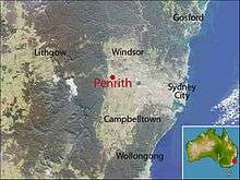
Penrith is a suburb and major centre in the metropolitan area of Sydney, New South Wales, Australia. It is located in Greater Western Sydney 50 kilometres (31 mi) west of the Sydney central business district on the banks of the Nepean River. Its elevation is 25 m. Penrith is the administrative seat of the local government area of the City of Penrith. It is also acknowledged on the register of the Geographical Names Board of New South Wales as one of only four cities within the Sydney metropolitan area. [2]
History
Penrith was named after the town of Penrith in Cumbria, England. The name is of Cumbric origin, a Celtic language of northern Britain related to Welsh. 'Pen' is Cumbric and Welsh for 'Head' or 'Chief' and the Cumbric 'Rid' (Rhydd in Welsh) means 'Ford' giving the name 'Chief Ford' or 'Hill Ford'. How it got the name is unclear. One theory is that in the early days, development in Penrith was entirely on one road, like the English Penrith, and someone familiar with both spotted the similarity and suggested the name. The earliest known written reference to the name Penrith dates back to 1819.[3]
Indigenous settlement
Prior to the arrival of the Europeans, the Penrith area was home to the Mulgoa tribe of the Darug people. They lived in makeshift huts called gunyahs, hunted native animals such as kangaroos, fished in the Nepean River, and gathered local fruits and vegetables such as yams. They lived under an elaborate system of Law which had its origins in the Dreamtime. Most of the Mulgoa were killed by smallpox or galgala shortly after the arrival of the First Fleet in 1788. Early British explorers such as Watkin Tench described them as friendly, saying, "they bade us adieu, in unabated friendship and good humour".[4]
English settlement
Watkin Tench was the first British explorer to visit the area in 1789 and named the Nepean River after Lord Evan Nepean, under-secretary to the home department.[5] Governor King began granting land in the area to settlers in 1804 with Captain Daniel Woodriff's 1,000 acres (4.0 km2) on the banks of the river the first land grant in the area. In 1814, William Cox constructed a road across the Blue Mountains which passed through Woodriff's land at Penrith. Initial settlement in the area was unplanned but substantial enough for a courthouse to be established in 1817.[3]

The post office was established in 1828, the Anglican church, St Stephens, was opened and consecrated 16 July 1839[6] followed by the Catholic Church, St Nicholas of Myra, in 1850. Two other prominent Penrith pioneers were Irish-born Thomas Jamison (1752/53-1811), a member of the First Fleet and surgeon-general of New South Wales (after whom Jamisontown is named), and his son, the landowner, physician and constitutional reformer Sir John Jamison (1776–1844). In 1824, Sir John erected the colony's finest Georgian mansion, Regentville House, near Penrith, on a ridge overlooking the Nepean River. Sir John established an impressive agricultural estate at Regentville and became a Member of the New South Wales Legislative Council. His grave can be seen in St Stephen's graveyard. Regentville House burned down in 1868 but most of its stonework was salvaged and used for building projects in and around Penrith.
Another well-known early settler was Thomas Frost (d. 1862) who arrived from Buckinghamshire in 1810. His wife Sarah[7] had been baptised by Samuel Marsden and her brother, Robert Rope, was reputed to be the first European born in Australia.[8][9] In a Petition to the governor of the colony, Sir Thomas Brisbane, on 13 October 1822, Thomas Frost declares that he is a Free Man and cultivates a farm on the Nepean River where he has a herd of 125 cattle. He mentions that the previous Governor, General Macquarie, was pleased to grant him, Thomas, a further 50 acres (20 ha) of land at Bathurst and he now craves the Governor's consent to drive cattle across the mountains to that property for pasturage. Frost's gravestone still stands in good condition in St. Stephen's Churchyard, Penrith.
The first bridge was opened over the Nepean in 1856 and was washed away the following year in a flood. The railway line was extended to Penrith in 1863, a school was established in 1865 and in 1871 the area became a municipality. It officially became a city in 1959.[3]
Circa 1882, Thornton Hall, situated on Mountain View Crescent, was built for Sydney Smith. It was subsequently owned by Henry Lack. The site had previously been owned by the Royal Army Engineers Depot. It is heritage-listed.[10]
Commercial area

Penrith is one of the major commercial centres in Greater Western Sydney. Penrith hosts a number of shopping complexes, the largest being Westfield Penrith Plaza, formerly managed by Lend Lease Group. The shopping centre features over 300 stores ranging from department stores to specialty shops.
Transport
Penrith Railway Station is a major railway station on the North Shore, Northern & Western Line of the Sydney Trains network. It has frequent services to and from the City and is also a stop on the intercity Blue Mountains Line.
Penrith railway station has its own bus interchange (as do several major railway stations in Sydney). Penrith is also served by Nightride Bus route 70.
Penrith can easily be accessed from St. Marys and Mt. Druitt via the Great Western Highway. Access from further east is best obtained by the M4 Western Motorway using either The Northern Road or Mulgoa Road exits. If travelling east from the Blue Mountains, access is best obtained by the Great Western Highway. Access from the south can be obtained by The Northern Road and Mulgoa Road, north from Castlereagh road or Richmond road, or from north and south via Westlink M7 and the M4 Western Motorway.
The NSW Government announced funding for the construction of the M9 in the 2014 state budget[11][12] to connect Camden, Penrith and Windsor. The proposed motorway will start from the M5 motorway and run west of the current M7 motorway.
Education
Penrith Public School and Penrith High School are two public schools in High Street. Jamison High School is in South Penrith. St Nicholas of Myra is a Catholic primary school, which is part of Catholic Education, Diocese of Parramatta, is located in Higgins Street.[3]
The Penrith campus of Nepean College of TAFE is located in the centre of town on Henry Street.[13] The Penrith campus of the University of Western Sydney is located in nearby Werrington.[14] The University of Sydney has a campus near Nepean Hospital in Kingswood, for research into the basic biomedical sciences and educating medical students at the hospital.
Landmarks and tourist attractions
- Nepean Belle, an old-world style paddlewheeler located on the Nepean River at Penrith.[15]
- Penrith Museum of Fire[16]
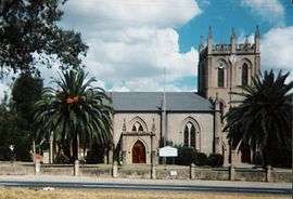
- St Stephen's Church (1839),[6] in High Street, and its historic graveyard, is heritage-listed[17]
- Penrith has a campus of the University of Western Sydney
- Sydney International Regatta Centre, which was the location for the rowing competitions for the 2000 Olympic Games[18]
- Panthers World of Entertainment
- Penrith Sake Brewery
- Nepean River
- Head of the River, which takes place at the regatta centre
- Red Cow Hotel, Station Street, is Penrith's oldest standing hotel
- Thornton Hall, Mountain View Crescent, is heritage-listed[19]
- Nepean Park, Castlereagh Road, is heritage-listed[20]
Culture
Arts
The Joan Sutherland Performing Arts Complex is in High Street next to the Council Chambers. Named after opera singer Joan Sutherland, the building was designed by architect Philip Cox and opened in 1990. It incorporates the Penrith Conservatorium of Music and the Q Theatre (Penrith), which had been operating in Station Street for 30 years before moving to the complex in 2006.[21]
Sport and recreation
Peppers Penrith Stadium, home of the Penrith Panthers NRL team]] Penrith has a number of local sporting clubs, the best known being the Penrith Panthers rugby league club who play in the National Rugby League. The club (one of the largest in Australia) has a massive entertainment complex and resort, Panthers World of Entertainment. Penrith's Junior Rugby League competition is the largest in the world, which also incorporates teams from the Blue Mountains, Blacktown and Windsor/Richmond areas. Visit the Penrith Junior League Website for more information.
The Panthers' home ground, Penrith Stadium (or Pepper Stadium), is also home to the Penrith Nepean United[22] soccer club. The club has been quite successful, perhaps the team's most memorable result has been a 2–1 Win against Asian Champions League contenders Sydney FC in a home game friendly match in front of 5000 fans on 17 August 2007.
There are also many other sporting associations, including cricket clubs, AFL clubs, Penrith City Outlaws gridiron team,[23] Panthers Triathlon club,[24] Penrith Emus Rugby, swimming, and soccer clubs. For a full list see the Penrith City Council's list of sporting groups.
Just west of Cranebrook is the Penrith Lakes Scheme, a system of flooded quarries that are now recreational lakes. One of these lakes hosted the rowing events of the Sydney 2000 Olympics. This facility is rated as a Level One course which can be used for international events.[25] The course itself is fully buoyed and can be modified to accommodate swimming and kayaking events.
North of the rowing lake is the Penrith Whitewater Stadium, the only pump-powered and artificial whitewater slalom course in the Southern Hemisphere.[26] It was built for the Sydney 2000 Olympics, and it continues to host international competitions on a regular basis.
Penrith is home to the Elite Fight Gym. A mixed martial arts training facility established by UFC fighter James Te-Huna.[27] In 2013, James te Huna left EFG to establish a rival MMA centre in St Mary's named Bee Stingz (located at Valley Fitness).
Media
Penrith is home to five local newspapers: The Western Weekender, Nepean News, Penrith Press, "Leonay & Emu Plains Times" and Penrith Star. It is also home to local radio station Vintage FM 87.6 (40's, 50's & 60's Music). NB: the current FM radio station "the edge" 96.1 FM evolved from the former (original) 2KA station founded by Frank Kelly.
Geography

Penrith sits on the western edge of the Cumberland Plain, a fairly flat area of Western Sydney, extending to Windsor in the north, Parramatta in the east and Thirlmere in the south. The Nepean River forms the western boundary of the suburb and beyond that, dominating the western skyline, are the Blue Mountains. There is a difference of opinion between Penrith City Council and the Geographical Names Board of New South Wales as to the boundaries of Penrith the suburb. The Board includes in its official description the area of Kingswood Park, Lemongrove and North Penrith, which the Council considers separate suburbs.[3][28][29]
Climate
Penrith has a humid subtropical climate (Köppen climate classification: Cfa) with hot summers and mild winters. The temperatures are a few degrees warmer than Sydney (Observatory Hill), especially on some spring and summer days, and a few degrees cooler on most nights of the year. In extreme cases, there could be a temperature differential of +10 degrees Celsius in summer due to seabreezes, which do not usually penetrate inland. The average Summer temperature range is 17.9 °C (64.2 °F) to 29.8 °C (85.6 °F) and in the Winter 6.2 °C (43.2 °F) to 18.6 °C (65.5 °F).[30]
Mean yearly rainfall is 719.2mm, which is less than Sydney (Observatory Hill) rainfall by 493.0mm (Sydney Observatory Hill's mean yearly rainfall is 1212.2mm [31]), as coastal showers do not penetrate inland. The highest recorded temperature is 46.5 °C (115.7 °F) on 18 January 2013. The lowest recorded temperature was -1.4 °C (29.5 °F) on 12 July 2002.[32][33]
| Climate data for Penrith | |||||||||||||
|---|---|---|---|---|---|---|---|---|---|---|---|---|---|
| Month | Jan | Feb | Mar | Apr | May | Jun | Jul | Aug | Sep | Oct | Nov | Dec | Year |
| Record high °C (°F) | 46.5 (115.7) |
45.0 (113) |
40.6 (105.1) |
34.2 (93.6) |
28.4 (83.1) |
26.0 (78.8) |
26.7 (80.1) |
29.7 (85.5) |
35.8 (96.4) |
38.9 (102) |
44.9 (112.8) |
42.3 (108.1) |
46.5 (115.7) |
| Average high °C (°F) | 30.8 (87.4) |
29.3 (84.7) |
27.5 (81.5) |
24.4 (75.9) |
21.0 (69.8) |
18.1 (64.6) |
17.7 (63.9) |
19.9 (67.8) |
23.3 (73.9) |
25.9 (78.6) |
27.3 (81.1) |
29.2 (84.6) |
24.5 (76.1) |
| Daily mean °C (°F) | 24.8 (76.6) |
23.9 (75) |
22.1 (71.8) |
18.8 (65.8) |
18.1 (64.6) |
12.5 (54.5) |
11.6 (52.9) |
13.1 (55.6) |
16.4 (61.5) |
19.0 (66.2) |
21.2 (70.2) |
23.1 (73.6) |
18.4 (65.1) |
| Average low °C (°F) | 18.5 (65.3) |
18.5 (65.3) |
16.6 (61.9) |
13.1 (55.6) |
9.3 (48.7) |
6.9 (44.4) |
5.4 (41.7) |
6.2 (43.2) |
9.4 (48.9) |
12.1 (53.8) |
15.0 (59) |
16.9 (62.4) |
12.3 (54.1) |
| Record low °C (°F) | 10.6 (51.1) |
11.6 (52.9) |
8.3 (46.9) |
3.6 (38.5) |
2.1 (35.8) |
−1.1 (30) |
−1.4 (29.5) |
−0.5 (31.1) |
2.2 (36) |
5.0 (41) |
7.8 (46) |
9.8 (49.6) |
−1.4 (29.5) |
| Average precipitation mm (inches) | 90.4 (3.559) |
131.6 (5.181) |
73.1 (2.878) |
42.2 (1.661) |
40.0 (1.575) |
51.6 (2.031) |
29.6 (1.165) |
30.1 (1.185) |
31.9 (1.256) |
54.5 (2.146) |
82.9 (3.264) |
60.1 (2.366) |
719.2 (28.315) |
| Average precipitation days (≥ 0.2 mm) | 11.5 | 11.7 | 11.8 | 10.3 | 11.6 | 15.2 | 12.4 | 8.5 | 7.5 | 9.3 | 12.1 | 10.7 | 132.6 |
| Average relative humidity (%) | 47 | 53 | 52 | 49 | 52 | 55 | 50 | 41 | 40 | 41 | 46 | 45 | 48 |
| Source: [34] | |||||||||||||
Population
Demographics
In the 2011 census, Penrith recorded a population of 3 people. Of these:[1]
- Age distribution: Residents had a similar range of ages to the country overall. The median age was 37 years, identical to the national median. Children aged under 15 years made up 17.1% of the population (national average is 19.3%) and people aged 65 years and over made up 17.5% of the population (national average is 14.0%).
- Ethnic diversity : 71% were born in Australia, compared to the national average of 70%; the next most common countries of birth were England 4.4%, New Zealand 2.0%, India 1.3%, Philippines 1.2% and China 0.9%. At home, 80% of residents only spoke English; other languages spoken at home included Arabic 1.0%, Cantonese 0.8%, Mandarin 0.7%, Spanish 0.7% and Tagalog 0.5%.
- Finances: The median household weekly income was $949, compared to the national median of $1,234. This difference is also reflected in real estate, with the median mortgage payment being $1,700 per month, compared to the national median of $1,800.
- Transport: On the day of the Census, 15.5% of employed people traveled to work on public transport and 61.1% by car (either as driver or as passenger).
- Housing: Nearly half (47.3%) of occupied private dwellings were separate houses, 25.3% were semi-detached (row or terrace houses, townhouses etc.), 26.0% were flats, units or apartments and 0.1% were other dwellings.
Notable residents


- Liam Zammit (b. 1981) cricketer
- Richie Benaud (1930-2015) cricketer and commentator
- Thomas Bent (1838–1909) Premier of Victoria 1904 to 1909, born in Penrith
- Nathan Bracken (b. 1977) Australian cricketer
- David Bradbury, Former Federal Member of Lindsay, and former Mayor of Penrith
- James Courtney, V8 Race car driver
- Firass Dirani, Australian TV actor
- Jason Dundas (b. 1981) Television presenter
- Mick Fanning (b. 1981) surfing world champion 2007
- Jessica Fox (born 1994), French-born Australian slalom canoer, Olympic silver (K-1 slalom), world championships bronze (C-1)[35]
- John Hastings (b. 1985) Australian cricketer
- Rev. Ross Hutchinson, spiritual leader, local radio host, popular local MC, former professional dancer (including television performances as Humphrey B. Bear[36])
- Tony Jones, Australian sports journalist based in Melbourne.
- Simon Keen (b. 1987) Australian U19s cricketer
- Jennifer Maiden (b. 1949) poet
- Nic Naitanui (b. 1990) Australian rules footballer, born in Penrith
- Grigor Taylor (b. 1943) 1970s TV actor
- James Te-Huna UFC Fighter
- Alan Whiticker (b. 1958) non-fiction author
- Melissa Wu (b. 1992) Olympian – diver
- Numerous Rugby League players: Greg Alexander, Ben Alexander (1970–1992), Mark Carroll, John Cartwright, Brad Fittler, Ryan Girdler, Phil Gould, Craig Gower, Des Hasler, Michael Jennings, Ken Kearney, Luke Lewis, Luke Rooney, Andrew Ryan and Tim Sheens.
- The Holy Soul, rock and roll band
- Mark Geyer (b. 1967) former professional rugby league footballer of the 1980s and '90s. An Australian international and New South Wales State of Origin representative, he is currently a media identity on breakfast radio in Sydney
- Ben St Lawrence (b. 1981) Olympic long-distance runner
- David 'DC' Love (b. 1985) Hip Hop recording artist
References
- 1 2 Australian Bureau of Statistics (31 October 2012). "Penrith (State Suburb)". 2011 Census QuickStats. Retrieved 21 November 2014.
- ↑ "Geographical Names Register Extract: List of placenames acknowledged as a CITY" (.CSV). Geographical Names Register (GNR) of NSW. Geographical Names Board of New South Wales. Retrieved 31 August 2008.
- 1 2 3 4 5 "Local suburb profile – Penrith". Penrith City Council. Retrieved 18 May 2008.
- ↑ Christopher Tobin. "The Dharug Story". Mananura Aboriginal Centre. Retrieved 18 May 2008.
- ↑ "The early land alienation pattern". Penrith City Council. Retrieved 18 May 2008.
- 1 2 "NINETY YEARS OLD.". The Sydney Morning Herald. National Library of Australia. 22 July 1929. p. 11. Retrieved 7 November 2014.
- ↑ Nepean Times, 19 August 1882, reports on her death
- ↑ The Australian Genealogist, Vol.II, part 3, July 1936, which gives his birth date as 5 September 1788.
- ↑ The Pioneers of Sydney Cove, p.87, which gives his birth date as 5 November 1788.
- ↑ State Heritage Register
- ↑ Levy, 'NSW budget: Government proposes M9 Outer Sydney Orbital roadway', Sydney Morning Herald Retrieved 11/07/2014
- ↑ Clennell, 'M9 Outer-western Sydney Orbital motorway part of big ticket $5.5b roads package unveiled in today's NSW Budget', The Daily Telegraph Retrieved 11/07/2014
- ↑ TAFE NSW – Campuses & Institutes Retrieved 18 June 2009
- ↑ Penrith | University of Western Sydney (UWS) Retrieved 18 June 2009
- ↑ "Nepean Belle Paddlewheeler 02 4733 1274". Nepean Belle Paddlewheeler 02 4733 1274.
- ↑ Penrith Museum of Fire Retrieved 18 June 2009
- ↑ The Heritage of Australia, Macmillan Company (1981) p. 2/58
- ↑ Sydney International Regatta Centre – Official Website
- ↑ State Heritage Register
- ↑ The Heritage of Australia, Macmillan Company (1981) p.2/58
- ↑ "Joan Sutherland Performing Arts Complex". Tourism NSW. Retrieved 22 May 2008.
- ↑ "Penrith Nepean United Football Club". Penrith Nepean United. Retrieved 29 December 2008.
- ↑ "Penrith City Outlaws". Penrith City Outlaws. Retrieved 29 December 2008.
- ↑ "Panthers Triathlon Club". Panthers Triathlon Club. Retrieved 29 December 2008.
- ↑ "Sydney International Regatta Centre, Penrith Club". SIRC. Retrieved 29 December 2008.
- ↑ A review of past and future Olympic Venues Retrieved 20 June 2009
- ↑ "Elite Fight Gym - Just another WordPress site". elitefightgym.com.au.
- ↑ "Cumberland Plain Vegetation Mapping Project". NSW Department of Environment & Climate Change. Retrieved 22 May 2008.
- ↑ "City of Penrith". Penrith City Council. Retrieved 22 May 2008.
- ↑ "Climate statistics for Penrith Lakes". Bureau of Meteorology. Retrieved 21 Feb 2015.
- ↑ "Climate statistics for Sydney Observatory Hill". Bureau of Meteorology. Retrieved 21 Feb 2015.
- ↑ "Sydney bakes on hottest day on record as bushfires rage". BBC News.
- ↑ "Climate statistics for Penrith Lakes". Bureau of Meteorology. Retrieved 18 May 2008.
- ↑ "Climate statistics for Penrith Lakes". Australian Bureau of Meteorology.
- ↑ "Jewish Australian kayaker Jessica Fox takes silver medal". Jewish Telegraphic Agency.
- ↑ "Ross Hutchison Foundation". Ross Hutchison Foundation.
| Wikimedia Commons has media related to Penrith, New South Wales. |
External links
- Experience Penrith Valley – Tourism site
- Future plan for Penrith CBD
- – Nepean Belle Paddlewheeler
- Penrith City Council website
- Penrith Local Suburb Profiles
- Penrith Panthers Rugby League Club
- Penrith on Visit NSW
- Penrith News & Events
- Western Weekender Newspaper
- SYDNEY.com – Penrith
- Ailsa McPherson (2015). "Q Theatre". Dictionary of Sydney. Dictionary of Sydney Trust. Retrieved 11 October 2015.[CC-By-SA]
Coordinates: 33°45′29″S 150°42′20″E / 33.75801°S 150.70544°E