Cameron, New York
| Cameron, New York | |
|---|---|
| Town | |
 Cameron, New York Location within the state of New York | |
| Coordinates: 42°11′55″N 77°23′28″W / 42.19861°N 77.39111°W | |
| Country | United States |
| State | New York |
| County | Steuben |
| Area | |
| • Total | 46.8 sq mi (121.1 km2) |
| • Land | 46.7 sq mi (121.0 km2) |
| • Water | 0.0 sq mi (0.1 km2) |
| Elevation | 1,621 ft (494 m) |
| Population (2000) | |
| • Total | 1,034 |
| • Density | 22.1/sq mi (8.5/km2) |
| Time zone | Eastern (EST) (UTC-5) |
| • Summer (DST) | EDT (UTC-4) |
| ZIP code | 14819 |
| Area code(s) | 607 |
| FIPS code | 36-11880 |
| GNIS feature ID | 0978778 |
Cameron is a town in Steuben County, New York, United States. The population was 1,034 at the 2000 census. The town is named after Dugald Cameron, an early settler and land agent of the Pulteney Estate.
The Town of Cameron is centrally located in the county, west of the City of Corning.
History
Around the year 1800, the first settler arrived near the present community of Cameron. The town was formed from the Town of Addison in the year 1822. Parts of Cameron were lost on the founding of the Towns of Thurston (1844) and Rathbone (1856).
The New York and Erie Railroad line through Cameron opened in September, 1850. Today, the line is owned by the Norfolk Southern Railway. NS and Canadian Pacific (the latter under haulage arrangements)operate trains over the route.
The population of Cameron in 1905 was 1,217.
Geography
According to the United States Census Bureau, the town has a total area of 46.8 square miles (121 km2), of which, 46.7 square miles (121 km2) of it is land and 0.04 square miles (0.10 km2) of it (0.04%) is water.
The Canisteo River flows through the town. Route 119 parallels the river.
Demographics
| Historical population | |||
|---|---|---|---|
| Census | Pop. | %± | |
| 1830 | 924 | — | |
| 1840 | 1,359 | 47.1% | |
| 1850 | 1,701 | 25.2% | |
| 1860 | 1,569 | −7.8% | |
| 1870 | 1,334 | −15.0% | |
| 1880 | 1,611 | 20.8% | |
| 1890 | 1,564 | −2.9% | |
| 1900 | 1,353 | −13.5% | |
| 1910 | 1,066 | −21.2% | |
| 1920 | 779 | −26.9% | |
| 1930 | 704 | −9.6% | |
| 1940 | 664 | −5.7% | |
| 1950 | 688 | 3.6% | |
| 1960 | 587 | −14.7% | |
| 1970 | 741 | 26.2% | |
| 1980 | 917 | 23.8% | |
| 1990 | 916 | −0.1% | |
| 2000 | 1,034 | 12.9% | |
| 2010 | 945 | −8.6% | |
| Est. 2014 | 948 | [1] | 0.3% |
As of the census[3] of 2000, there were 1,034 people, 359 households, and 266 families residing in the town. The population density was 22.1 people per square mile (8.5/km²). There were 450 housing units at an average density of 9.6 per square mile (3.7/km²). The racial makeup of the town was 98.07% White, 0.10% African American, 0.77% Native American, 0.10% Asian, and 0.97% from two or more races. Hispanic or Latino of any race were 0.29% of the population.
There were 359 households out of which 35.1% had children under the age of 18 living with them, 58.2% were married couples living together, 9.5% had a female householder with no husband present, and 25.9% were non-families. 17.3% of all households were made up of individuals and 6.4% had someone living alone who was 65 years of age or older. The average household size was 2.88 and the average family size was 3.20.
In the town the population was spread out with 28.9% under the age of 18, 6.4% from 18 to 24, 30.9% from 25 to 44, 24.9% from 45 to 64, and 8.9% who were 65 years of age or older. The median age was 36 years. For every 100 females there were 113.2 males. For every 100 females age 18 and over, there were 111.2 males.
The median income for a household in the town was $32,083, and the median income for a family was $37,411. Males had a median income of $27,440 versus $21,989 for females. The per capita income for the town was $15,455. About 16.5% of families and 21.2% of the population were below the poverty line, including 22.3% of those under age 18 and 17.0% of those age 65 or over.
The population in 1890 was 1,522.
Communities and locations in the Town of Cameron
- Bonny Hill – A location in the northeast part of the town and northeast of North Cameron.
- Boyds Corner – A location south of South Cameron on Jackson Hill Road.
- Cameron – The hamlet of Cameron by the junction of County Roads 10 and 119 by the Canisteo River.
- Cameron Mills – A hamlet by the town line in the southeast part of the town.
- North Cameron – A hamlet near the north town line on County Road 10A.
- South Cameron – A hamlet southwest of Cameron hamlet, located on Jackson Hill Road.
- West Cameron – A hamlet northwest of Cameron hamlet on Route 119.
Notable residents
- William W. Averell, (1832–1900), born in Cameron, United States Army officer and patenter of asphalt pavement[4]
References
- ↑ "Annual Estimates of the Resident Population for Incorporated Places: April 1, 2010 to July 1, 2014". Retrieved June 4, 2015.
- ↑ "Census of Population and Housing". Census.gov. Archived from the original on May 11, 2015. Retrieved June 4, 2015.
- ↑ "American FactFinder". United States Census Bureau. Archived from the original on 2013-09-11. Retrieved 2008-01-31.
- ↑ Who Was Who in America, Historical Volume, 1607-1896. Chicago: Marquis Who's Who. 1963.
External links
Coordinates: 42°11′57″N 77°24′23″W / 42.19917°N 77.40639°W
Municipalities and communities of Steuben County, New York, United States | ||
|---|---|---|
| Cities | 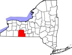 | |
| Towns | ||
| Villages | ||
| CDPs |
| |
| Hamlets | ||
| Footnotes | ‡This populated place also has portions in an adjacent county or counties | |