California State Route 4
| ||||
|---|---|---|---|---|
 | ||||
| Route information | ||||
| Defined by Streets and Highways Code § 304 | ||||
| Maintained by Caltrans | ||||
| Length: | 197 mi[1] (317 km) | |||
| Existed: | 1934[2] – present | |||
| Tourist routes: |
| |||
| Restrictions: | Segment through Ebbetts Pass closed in winter | |||
| Major junctions | ||||
| West end: | San Pablo Avenue in Hercules | |||
|
| ||||
| East end: |
| |||
| Highway system | ||||
| ||||

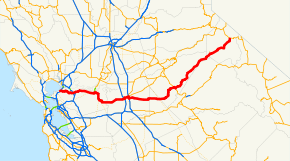
State Route 4 (SR 4) is a state highway in the U.S. state of California, routed from Interstate 80 in the San Francisco Bay Area to State Route 89 in the Sierra Nevada. It passes through Ebbetts Pass and contains the Ebbetts Pass Scenic Byway, a National Scenic Byway.
SR 4 roughly parallels the Sacramento-San Joaquin River Delta, a popular area for boating and fishing. There are a number of accesses to marinas and other attractions.
Route description
State Route 4 is part of the California Freeway and Expressway System[3] and is eligible for the State Scenic Highway System.[4] However, it is only a scenic highway as designated by Caltrans from a point east of Arnold to SR 89.[5] SR 4 is also known as the John Muir Parkway from I-80 in Hercules to I-680 near Martinez, named for the environmentalist John Muir.[6] The stretch through Franklin Canyon was once known as "Blood Alley."[7]
SR 4, an east–west highway, begins in Hercules at San Pablo Avenue next to the Interstate 80 junction as part of John Muir Parkway. (The actual parkway extends a bit past the western terminus.) The road is an expressway from its starting point until it approaches Martinez, at which point it becomes a full freeway (the California Delta Highway) passing Concord, Pittsburg, and Antioch. The John Muir National Historic Site is located directly north of Route 4 on Alhambra Avenue in Martinez. Alhambra Avenue at SR 4 is also the site of the Franklin Canyon Adobe. BART tracks run in the median of the freeway from the Port Chicago Highway interchange in Concord to the Bailey Road interchange in Bay Point, where the line currently ends at the Pittsburg/Bay Point Station. Access to that station is provided by a pedestrian bridge crossing over the eastbound lanes of Highway 4. After Antioch, the freeway turns southward at its intersection with State Route 160, turning into a suburban and rural road bypassing the Bay Area's outermost eastern suburbs (Oakley and Brentwood); this section is also known as the John Marsh Heritage Highway.
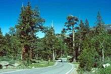
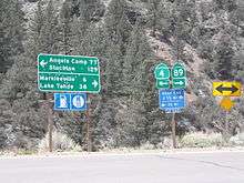
Route 4 east continues to Stockton, where it briefly joins I-5 and then enters a separate freeway (known locally as the Crosstown Freeway) routing almost directly through downtown Stockton. The route then runs concurrent with State Route 99 before running eastward into the Sierra through Angels Camp, one of the richest quartz mining sections of the Mother Lode and home of "The Celebrated Jumping Frog of Calaveras County", and Calaveras Big Trees State Park. The route runs through the 8,050 ft (2,450 m). Pacific Grade Summit on its way up to the 8,730 ft (2,660 m) Ebbetts Pass and ends at State Route 89 ten miles (16 km) west of Topaz Lake, on the California–Nevada border. The portion from Arnold to its terminus is designated the Ebbetts Pass Scenic Byway, which is eventually one lane.
Through the mountains, SR 4 is not suitable for large trucks, buses, or RVs, as it becomes very steep and narrow, with no center dividing line shortly after the Mount Reba Turnoff to Bear Valley Ski area, with tight switchbacks. The pass is not plowed for snow, and thus closes during the winter months often from November through as late as May. Thus, no passage between the Mount Reba Turnoff and Markleeville is possible. The western slope is plowed and rarely closes, even for a few hours, but often has chain restrictions during and immediately following storms, usually just east of Arnold. The eastern slope is not plowed.
History
Although segments of Route 4 were part of the state highway system since 1909, Route 4 was officially designated as such between US Route 40 (now Interstate 80) and State Route 99 in 1934. Prior to that date, the then existing segment was officially known as the "Borden Highway", and the bridge over the San Joaquin River is still referred to as the "Borden Highway Bridge" in tidal tables. Construction of Route 4 did not finish until 1935, however.[2]
The portion of Route 4 from US Route 40 to State Route 24 was added to the highway system in 1933 as Legislative Route Number (LRN) 106. East of the concurrency with State Route 24 to State Route 49, Route 4 was designated as LRN 75 from 1931-1934. Finally, the segment from State Route 49 to State Route 89 was signed as LRN 24 from 1909 to 1934.[2]
In the 1970s, a significant portion of the Filipino American community of "Little Manila" was demolished when the "Crosstown Freeway" was constructed,[8] displacing what was once the largest population of Filipinos outside of the Philippines.[9]
From 1998 to 2009, a road built by the State Route 4 Bypass Authority, named the State Route 4 Bypass, opened in three phases, bypassing Route 4 in Oakley and Brentwood to the south and west.[10][11] Many of the signs and local maps designated this extension as simply "Bypass Road." A section of Marsh Creek Road was widened to serve as the connection between the bypass built by the authority and the original Route 4 towards Stockton. In 2012, Caltrans handed over authority for State Route 4 in Oakley and Brentwood to the respective cities. In return, it gained control of the bypass and the upgraded section of Marsh Creek Road, which officially became State Route 4.[12]
Construction is currently underway on widening the freeway section of Route 4 through Antioch, Oakley and Brentwood, with the final configuration as three mixed use lanes and one High Occupancy Vehicle (HOV) lane in each direction and auxiliary lanes between interchanges as far as the interchange with Route 160. The median will accommodate an extension of the Bay Area Rapid Transit (BART) system. All work at the Loveridge Road and Somersville Road/Auto Center Drive interchanges has been completed; however, the HOV lane east of the Loveridge Road overpass remains closed pending completion of construction at the L Street/Contra Loma Boulevard and A Street/Lone Tree Way interchanges. Speed on the freeway through the Antioch portion of Route 4 is limited to 55 miles per hour (90 kph), as there is severe congestion, as well as areas where no shoulder exists due to temporary concrete barriers in place.
Only the portion of the bypass from California SR 160 to the Sand Creek Road interchange is a multi-lane freeway. The portion from Sand Creek Road to Vasco Road is single-lane each way and has signal-controlled grade crossings at Balfour Road and Marsh Creek Road. In May 2010, this narrow stretch of the road handled 27,000 to 30,000 vehicles per day.[13] In 2011, Caltrans awarded $25 million toward upgrading the section from Lone Tree Way to Sand Creek Road to a full freeway and constructing an interchange at Sand Creek Road.[14]
Effective in early March 2016, reconfiguration of the intersection of SR 4 and SR 160 was officially opened, allowing westbound SR 4 traffic to access northbound SR 160 directly and southbound SR 160 to access eastbound SR 4.<ref "Szymanski">Szymanski, Kyle. "East County connector ramps open." Brentwood Press. March 4, 2016. Accessed March 5, 2016.</ref>
The freeway segment of SR 4 in Stockton is part of a proposed route to upgrade SR 99 into I-7 or I-9. Under one proposal, the new interstate would go along SR 99 from the split with I-5 at Wheeler Ridge north through Fresno to Stockton, where the proposed route would then turn west via the SR 4 freeway to a terminus at I-5.[15]
In 2016, Pittsburg moved to install surveillance cameras along their portion of the route, in response to a series of 20 freeway shootings in the area that had taken the lives of six people, and injured 11, in the past year.[16]
Major intersections
This table reflects the transfer of the State Route 4 Bypass to Caltrans in 2012. Except where prefixed with a letter, postmiles were measured on the road as it was in 1964, based on the alignment that existed at the time, and do not necessarily reflect current mileage. R reflects a realignment in the route since then, M indicates a second realignment, L refers an overlap due to a correction or change, and T indicates postmiles classified as temporary (for a full list of prefixes, see the list of postmile definitions).[17] Segments that remain unconstructed or have been relinquished to local control may be omitted. The numbers reset at county lines; the start and end postmiles in each county are given in the county column.
| County | Location | Postmile [17][18][19] | Exit [20][21] | Destinations | Notes |
|---|---|---|---|---|---|
| Contra Costa CC 0.00-48.39 | Hercules | 0.00 | 1A | San Pablo Avenue | At-grade intersection; former US 40; west end of SR 4 |
| 0.00 | 1B | No exit number eastbound; I-80 exit 23; Contra Costa Veterans Memorial Expressway continues onto I-80 west | |||
| 0.78 | 1C | Willow Avenue | Westbound exit and eastbound entrance | ||
| | R1.70 | 1 | Sycamore Avenue | Eastbound exit and entrance | |
| | | East end of freeway | |||
| | R1.70 | Claeys Lane | Interchange; westbound exit and entrance | ||
| | 2.70 | 3 | Franklin Canyon | At-grade intersection eastbound; interchange westbound | |
| | | West end of freeway | |||
| | T4.89 | 5 | |||
| | R5.17 | 6 | McEwen Road – Port Costa | Westbound exit and eastbound entrance | |
| Martinez | R8.55 | 9 | Alhambra Avenue – Martinez | ||
| R9.19 | 10 | Pine Street, Center Avenue | |||
| R10.33 | 11 | Morello Avenue, Glacier Drive | |||
| 12.41 | 12A | Pacheco Boulevard – Pacheco | Former SR 21 | ||
| | 12.67 | 12 | Signed as exits 12B (south) and 12C (north); I-680 exit 53 | ||
| | R13.65 | 13 | Solano Way | ||
| Concord | R14.67 | 15A | SR 242 exits 3B-C | ||
| R15.42 | 15B | Port Chicago Highway | |||
| | R16.83 | 17 | Willow Pass Road | ||
| | R18.83 | 19 | San Marco Boulevard – Bay Point | ||
| | R20.10 | 20 | Bailey Road | Signed as exits 20A (south) and 20B (north) | |
| Pittsburg | 23.05 | 23 | Railroad Avenue, Harbor Street | ||
| 24.32 | 24 | Loveridge Road – Pittsburg | |||
| Antioch | 26.01 | 26 | Somersville Road, Auto Center Drive | Signed as exits 26A (Somersville Road) and 26B (Auto Center Drive) | |
| 26.94 | 27 | L Street, Contra Loma Boulevard | Eastbound entrance under construction; former exit 27A eastbound | ||
| 27.29 | 27B | G Street – Central Antioch | Closed; former eastbound exit and westbound entrance | ||
| R27.79 | 28 | Lone Tree Way, A Street | |||
| R28.94 | 29 | Hillcrest Avenue | |||
| 31.13 | 30 | Former SR 4 east; west end of bypass; westbound exit and eastbound entrance opened March 2016 | |||
| R31.50 | 31 | Laurel Road | |||
| Brentwood | R32.90 | 33 | Lone Tree Way | ||
| | 34 | Sand Creek Road | |||
| | East end of freeway | ||||
| | Balfour Road | At-grade intersection; proposed interchange[22] | |||
| | | Marsh Creek Road, Vasco Road – Concord, Livermore | East end of bypass | ||
| | 43.97 | Byron Highway, Marsh Creek Road – Brentwood | Byron Highway was former SR 4 west | ||
| Byron | R44.37 | ||||
| San Joaquin SJ 0.00-38.06 | | 5.96 | |||
| Stockton | 15.91 25.36[N 1] | Interchange; west end of I-5 overlap; Dr. Martin Luther King Jr. Boulevard was former SR 4 east / Charter Way; I-5 exit 471 | |||
| | West end of freeway on I-5 | ||||
| 26.19[N 1] R16.06 | 65B | East end of I-5 overlap; no exit number eastbound; I-5 exit 472 | |||
| T15.32 | Fresno Avenue | Exit is on the left; serves Port of Stockton | |||
| R16.62 | 66A | El Dorado Street, Center Street – Downtown Stockton | Serves Stockton Arena and Ballpark; no exit number eastbound | ||
| R17.05 | 66B | Stanislaus Street – Downtown Stockton | Signed as exit 66 eastbound | ||
| R17.71 | 67 | Wilson Way | Former US 50 / US 99 | ||
| R18.77 | 68A | Filbert Street | Signed as exit 68 westbound | ||
| R19.44 18.68[N 2] | 68B | West end of SR 99 overlap; no exit number westbound; SR 99 exit 254A | |||
| | 18.15[N 2] | 253 | Main Street | Closed; former westbound exit only | |
| Stockton | 18.02[N 2] | 253 | Dr. Martin Luther King Jr. Boulevard | Closed; former interchange with no westbound exit; former SR 26 west / Charter Way | |
| | | East end of freeway on SR 99 | |||
| | 17.50[N 2] | Interchange; east end of SR 99 overlap; SR 99 exit 252B | |||
| | 24.87 | ||||
| Farmington | 33.10 | ||||
| Stanislaus STA 0.00-8.89 | | 4.54 | |||
| Calaveras CAL R0.00-R65.87 | Copperopolis | R8.14 | |||
| Angels Camp | R21.09 | Former overlap with SR 4 east | |||
| | | Former SR 4 west | |||
| Vallecito | 26.22 | ||||
| Alpine ALP R0.00-31.68 | | 3.89 | |||
| Bullion | 31.68 | East end of SR 4 | |||
1.000 mi = 1.609 km; 1.000 km = 0.621 mi
| |||||
Angels Camp business route
| |
|---|---|
| Location: | Angels Camp, California |
| Existed: | 2013–present |
State Route 4 Business is a locally maintained business loop within the city of Angels Camp, California. It was established in August 2013 to attract customers to businesses along the parent route's former alignment, prior to the completion of the Angels Camp Bypass. It runs along South Main Street (co-signed with State Route 49), between State Route 4 and Vallecito Road, then turns east along Vallecito Road.[23][24]
References
- ↑ "January 1, 2006 California Log of Bridges on State Highways". California Department of Transportation. Retrieved 2011-11-29. Does not reflect the transfer of the State Route 4 Bypass to Caltrans in 2012.
- 1 2 3 "California Highways: State Route 4". Cahighways.org. Retrieved 2011-11-29.
- ↑ "CA Codes (shc:250-257)". Leginfo.ca.gov. Retrieved 2011-11-29.
- ↑ "CA Codes (shc:260-284)". Leginfo.ca.gov. Retrieved 2011-11-29.
- ↑ California Department of Transportation, Officially Designated Scenic Highways, accessed 2009-09-14
- ↑ 2007 Named Freeways, Highways, Structures and Other Appurtenances in California (PDF). Caltrans. pp. 116–117. Retrieved 2007-03-28.
- ↑ Cabanatuan, Michael (1999-06-10). "Project to Straighten Out Part of Highway 4". San Francisco Chronicle. pp. A–17. Retrieved 2008-03-14.
- ↑ Antonio T. Tiongson; Edgardo V. Gutierrez; Ricardo Valencia Gutierrez; Dawn Bohulano Mabalon (2006). "Losing Little Manila: Race and Redevelopment in Filipina/o Stockton, California". Positively No Filipinos Allowed: Building Communities and Discourse. Temple University Press. pp. 73–89. ISBN 978-1-59213-123-5.
- ↑ Deborah Kong (26 December 2002). "Filipino Americans work to preserve heritage". Star Bulletin. Honololu. Associated Press. Retrieved 2 January 2015.
Rachael Myrow (2 September 2013). "Stockton's Little Manila: the Heart of Filipino California". KQED. San Francisco. Retrieved 1 January 2015.
"Little Manila: Filipinos in California's Heartland". KVIE. 2014. Retrieved 1 January 2015. - ↑ Faigin, Daniel. "State Route 4". California Highways. Retrieved 2012-11-12.
- ↑ "State Route 4 Bypass Authority". Retrieved 2011-11-12.
- ↑ Lafferty, Justin (January 26, 2012). "Brentwood, Oakley celebrate Highway 4 transfer". Brentwood Press. Retrieved February 2, 2012.
- ↑ Coetsee, Rowena (May 28, 2010). "Safety fears still dog East County roadway, but opinions differ over causes". San Jose Mercury News.
- ↑ Lafferty, Justin (September 29, 2011). "Savings lead to Bypass progress". Brentwood Press. Retrieved 2011-11-23.
- ↑ "Chapter 3" (PDF). Caltrans Route 99 Enhancement Plan (PDF). California Department of Transportation.
Interstate designation, under the current proposal, would apply to the 260-mile (420 km) segment between the junction of State Route 99 with I-5 south of Bakersfield to I-5 in Stockton using State Route 4 as the connector to I-5. Since there is an I-99 route currently in existence in Pennsylvania, it is anticipated that should designation be granted, the Route 99 designation would become either I-7 or I-9 to satisfy Interstate numbering convention.
- ↑
- 1 2 California Department of Transportation. "State Truck Route List". Sacramento: California Department of Transportation. Archived from the original (XLS file) on June 30, 2015. Retrieved June 30, 2015.
- ↑ California Department of Transportation, Log of Bridges on State Highways, July 2007
- ↑ California Department of Transportation, All Traffic Volumes on CSHS, 2005 and 2006
- ↑ California Department of Transportation, California Numbered Exit Uniform System, State Route 4 Freeway Interchanges, Retrieved on 2009-02-05.
- ↑ California Department of Transportation, California Numbered Exit Uniform System, State Route 99 Freeway Interchanges, Retrieved on 2009-02-05.
- ↑ State Route 4 Bypass Authority: Maps, accessed December 2007
- ↑ Petesen, Tracey (15 August 2013). "Directing Traffic Downtown". My Mother Lode. Retrieved 4 January 2014.
- ↑ City of Angels Camp, CA. "CITY OF ANGELS CITY COUNCIL MINUTES" (PDF). Retrieved 4 January 2014.
CONSIDERATION OF ESTABLISHING PORTIONS OF SR49 AND VALLECITO ROAD AS A BUSINESS ROUTE MOTION by Council Member Lynch, seconded by council Member Kulm and carried 4-0 APPROVING PORTIONS OF SR49 AND VALLECITO ROAD BE ESTABLISHED AS BUSINESS ROUTE.
External links
| Wikimedia Commons has media related to California State Route 4. |
- California @ AARoads.com – State Route 4
- Caltrans: Route 4 highway conditions
- California Highways: Route 4
- Ebbetts Pass Scenic Byway
- Scenic 4 - Ebbetts Pass Scenic Byway
- Cal-NExUS: Route 4
