Bunker Hill, Kansas
| Bunker Hill, Kansas | |
|---|---|
| City | |
 Location within Russell County and Kansas | |
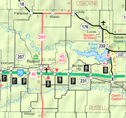 KDOT map of Russell County (legend) | |
| Coordinates: 38°52′29″N 98°42′10″W / 38.87472°N 98.70278°WCoordinates: 38°52′29″N 98°42′10″W / 38.87472°N 98.70278°W | |
| Country | United States |
| State | Kansas |
| County | Russell |
| Founded | 1871 |
| Incorporated | 1871 |
| Area[1] | |
| • Total | 1.38 sq mi (3.57 km2) |
| • Land | 1.38 sq mi (3.57 km2) |
| • Water | 0 sq mi (0 km2) |
| Elevation | 1,860 ft (567 m) |
| Population (2010)[2] | |
| • Total | 95 |
| • Estimate (2013[3]) | 95 |
| • Density | 69/sq mi (27/km2) |
| Time zone | Central (CST) (UTC-6) |
| • Summer (DST) | CDT (UTC-5) |
| ZIP code | 67626 |
| Area code | 785 |
| FIPS code | 20-09225 [4] |
| GNIS feature ID | 0475228 [5] |
Bunker Hill is a city in Russell County, Kansas, United States.[6] As of the 2010 census, the population of the city was 95.[7]
History
J. B. Corbett and Valentine Harbaugh, leaders of a colony from Ohio, founded Bunker Hill at a site on the Kansas Pacific Railway in the summer of 1871.[8][9] The settlement received its name from a Butterfield Overland Despatch station, built in 1865, that had preceded it on the site.[10] County commissioners declared Bunker Hill the county seat in 1872, but, two years later, a popular vote moved the seat to nearby Russell. Many Bunker Hill residents moved with it, stunting the growth and development of the town. By 1883, a small business community emerged, including a hotel, flour mill, and several shops.[8]
Geography
Bunker Hill is located at 38°52′29″N 98°42′10″W / 38.87472°N 98.70278°W (38.874716, -98.702759),[11] at an elevation of 1,860 feet (567 m).[5] Located in north-central Kansas, Bunker Hill is 108 miles (174 km) northwest of Wichita and 221 miles (355 km) west of Kansas City.[12] Located 1 mile (1.7 km) north of Interstate 70, it is roughly 8 miles (13 km) east of Russell, the county seat.[13]
The community lies in the Smoky Hills region of the Great Plains approximately 5 miles (8 km) north of the Smoky Hill River and 7 miles (11 km) south of the Saline River.[6][13] Wilson Lake lies 6 miles (10 km) to the northeast.[13]
According to the United States Census Bureau, the city has a total area of 1.38 square miles (3.57 km2), all of it land.[1]
Climate
The climate in this area is characterized by hot, humid summers and generally mild to cool winters. According to the Köppen Climate Classification system, Bunker Hill has a humid subtropical climate, abbreviated "Cfa" on climate maps.[14]
Demographics
| Historical population | |||
|---|---|---|---|
| Census | Pop. | %± | |
| 1880 | 135 | — | |
| 1890 | 157 | 16.3% | |
| 1910 | 242 | — | |
| 1920 | 268 | 10.7% | |
| 1930 | 298 | 11.2% | |
| 1940 | 253 | −15.1% | |
| 1950 | 271 | 7.1% | |
| 1960 | 200 | −26.2% | |
| 1970 | 181 | −9.5% | |
| 1980 | 124 | −31.5% | |
| 1990 | 111 | −10.5% | |
| 2000 | 101 | −9.0% | |
| 2010 | 95 | −5.9% | |
| Est. 2015 | 97 | [15] | 2.1% |
| U.S. Decennial Census | |||
2010 census
As of the 2010 census, there were 95 people, 47 households, and 21 families residing in the city. The population density was 67.9 people per square mile (26.4/km²). There were 66 housing units at an average density of 47.1 per square mile (18.3/km²). The racial makeup of the city was 97.9% White, 1.1% Asian, and 1.1% from some other race. Hispanics and Latinos of any race were 1.1% of the population.[7]
There were 47 households of which 23.4% had children under the age of 18 living with them, 36.2% were married couples living together, 2.1% had a male householder with no wife present, 6.4% had a female householder with no husband present, and 55.3% were non-families. 53.2% of all households were made up of individuals, and 42.6% had someone living alone who was 65 years of age or older. The average household size was 2.02, and the average family size was 3.00.[7]
In the city, the population was spread out with 21.1% under the age of 18, 6.1% from 18 to 24, 14.8% from 25 to 44, 30.6% from 45 to 64, and 27.4% who were 65 years of age or older. The median age was 48.9 years. For every 100 females, there were 102.1 males. For every 100 females age 18 and over, there were 87.5 males age 18 and over.[7]
The median income for a household in the city was $31,875, and the median income for a family was $36,250. Males had a median income of $30,313 versus $37,917 for females. The per capita income for the city was $20,661. 4.2% of families and 2.0% of the population were below the poverty line, including 3.7% of those under age 18 and 0.0% of those age 65 or over.[7]
2000 census
As of the census[4] of 2000, there were 101 people, 51 households, and 29 families residing in the city. The population density was 73.2 people per square mile (28.3/km²). There were 68 housing units at an average density of 49.3/sq mi (19.0/km²). The racial makeup of the city was 100.00% White. Hispanic or Latino of any race were 6.93% of the population.
There were 51 households out of which 13.7% had children under the age of 18 living with them, 51.0% were married couples living together, 3.9% had a female householder with no husband present, and 43.1% were non-families. 39.2% of all households were made up of individuals and 11.8% had someone living alone who was 65 years of age or older. The average household size was 1.98 and the average family size was 2.59.
In the city the population was spread out with 17.8% under the age of 18, 1.0% from 18 to 24, 19.8% from 25 to 44, 37.6% from 45 to 64, and 23.8% who were 65 years of age or older. The median age was 51 years. For every 100 females there were 83.6 males. For every 100 females age 18 and over, there were 80.4 males.
Economy
As of 2012, 70.7% of the population over the age of 16 was in the labor force. 0.0% was in the armed forces, and 70.7% was in the civilian labor force with 70.7% being employed and 0.0% unemployed. The composition, by occupation, of the employed civilian labor force was: 34.5% in service occupations; 32.8% in sales and office occupations; 17.2% in management, business, science, and arts; 12.1% in natural resources, construction, and maintenance; 3.4% in production, transportation, and material moving. The three industries employing the largest percentages of the working civilian labor force were: retail trade (27.6%); arts, entertainment, and recreation, and accommodation and food services (13.8%); and wholesale trade (13.8%).[7]
The cost of living in Bunker Hill is relatively low; compared to a U.S. average of 100, the cost of living index for the community is 80.0.[16] As of 2012, the median home value in the city was $45,000, the median selected monthly owner cost was $717 for housing units with a mortgage and $275 for those without, and the median gross rent was $913.[7]
Government
Bunker Hill is a city of the third class with a mayor-council form of government. The city council consists of five members, and it meets on the second Tuesday of each month.[17]
Bunker Hill lies within Kansas's 1st U.S. Congressional District. For the purposes of representation in the Kansas Legislature, the city is located in the 36th district of the Kansas Senate and the 109th district of the Kansas House of Representatives.[17]
Education
Bunker Hill lies within Unified School District 407, Russell County Schools.[18]
Infrastructure
Transportation
Interstate 70 and U.S. Route 40 run concurrently east-west a mile south of the city.[13] Bunker Hill-Luray Road, a paved county road, runs north-south along the city's western edge.[19]
Union Pacific Railroad operates one freight rail line, its Kansas Pacific (KP) Line, through Bunker Hill. The line runs east-west through the community.[20]
Utilities
Western Electric provides electricity to local residents. Rural Telephone provides landline telephone service, and Nex-Tech offers cable television and internet access.[21] Most residents use natural gas for heating fuel; service is provided by Midwest Energy, Inc.[16][21]
Media
Bunker Hill is in the Wichita-Hutchinson, Kansas television market.[22] Smoky Hills Public Television, the PBS member network for western Kansas, is headquartered in Bunker Hill.[23]
Culture
Points of interest
The Bunker Hill Museum, located in an old limestone church one block east of Main Street, displays documents and artifacts from the community's history.[24]
In popular culture and the arts
Bunker Hill is the setting and namesake of the 2008 film Bunker Hill.[25]
Notable people
Notable individuals who were born in and/or have lived in Bunker Hill include:
- Mary Ann Bickerdyke (1817-1901), American Civil War nurse[26]
References
- 1 2 "US Gazetteer files 2010". United States Census Bureau. Archived from the original on 2012-01-24. Retrieved 2012-07-06.
- ↑ "American FactFinder". United States Census Bureau. Retrieved 2012-07-06.
- ↑ "Population Estimates". United States Census Bureau. Retrieved 2014-09-10.
- 1 2 "American FactFinder". United States Census Bureau. Archived from the original on 2013-09-11. Retrieved 2008-01-31.
- 1 2 "US Board on Geographic Names". United States Geological Survey. 2007-10-25. Retrieved 2008-01-31.
- 1 2 "2003-2004 Official Transportation Map" (PDF). Kansas Department of Transportation. 2003. Retrieved 2010-12-11.
- 1 2 3 4 5 6 7 "American FactFinder 2". United States Census Bureau. Retrieved 2014-09-10.
- 1 2 Cutler, William G. (1883), "Russell County, Part 5", History of the State of Kansas, Chicago: A.T. Andreas, retrieved 2010-04-17
- ↑ Kansas State Historical Society (1916). Biennial Report of the Board of Directors of the Kansas State Historical Society. Kansas State Printing Plant. p. 279.
- ↑ "The Early History of Russell County". Russell County Historical Society. Retrieved 2010-04-17.
- ↑ "US Gazetteer files: 2010, 2000, and 1990". United States Census Bureau. 2011-02-12. Retrieved 2011-04-23.
- ↑ "City Distance Tool". Geobytes. Retrieved 2010-04-17.
- 1 2 3 4 "General Highway Map - Russell County, Kansas" (PDF). Kansas Department of Transportation. 2010-10-01. Retrieved 2010-12-11.
- ↑ Climate Summary for Bunker Hill, Kansas
- ↑ "Annual Estimates of the Resident Population for Incorporated Places: April 1, 2010 to July 1, 2015". Retrieved July 2, 2016.
- 1 2 "Bunker Hill, Kansas". City-Data.com. Retrieved 2014-09-10.
- 1 2 "Bunker Hill". Directory of Kansas Public Officials. The League of Kansas Municipalities. Retrieved 2011-07-23.
- ↑ "USD 407 Russell County Schools". USD 407. Retrieved 2010-07-23.
- ↑ "Kansas Road Map Travel Guide". MilebyMile.com. 2009. Retrieved 2010-12-11.
- ↑ "UPRR Common Line Names" (PDF). Union Pacific Railroad. Retrieved 2010-04-17.
- 1 2 "Utilities". Russell County, Kansas Economic Development & CVB. Retrieved 2014-09-10.
- ↑ "Kansas". TV Market Maps. EchoStar Knowledge Base. Retrieved 2014-09-10.
- ↑ "Contact Us". Smoky Hills Public Television. Retrieved 2011-02-16.
- ↑ "Bunker Hill". The Amazing 100 Miles Tourism Coalition. Retrieved 2014-09-10.
- ↑ "The Battle for Bunker Hill (2008)". IMDb. Retrieved 2010-11-01.
- ↑ Blackmar, Frank W., ed. (1912). "Bickerdyke, Mary Ann". Kansas: a cyclopedia of state history, embracing events, institutions, industries, counties, cities, towns, prominent persons, etc. 1. Chicago: Standard. pp. 178–179.
External links
| Wikimedia Commons has media related to Bunker Hill, Kansas. |
- City
- Schools
- USD 407, local school district
- Maps
- Bunker Hill City Map, KDOT
Municipalities and communities of Russell County, Kansas, United States | ||
|---|---|---|
| Cities | 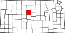 | |
| Townships | ||
| Unincorporated communities | ||
| Footnotes | ‡This populated place also has portions in an adjacent county or counties | |