Russell County, Kansas
| Russell County, Kansas | |
|---|---|
| County | |
 Russell County Courthouse in Russell | |
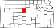 Location in the U.S. state of Kansas | |
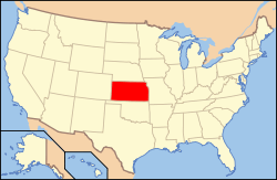 Kansas's location in the U.S. | |
| Founded | February 26, 1867 |
| Named for | Alva P. Russell |
| Seat | Russell |
| Largest city | Russell |
| Area | |
| • Total | 899 sq mi (2,328 km2) |
| • Land | 886 sq mi (2,295 km2) |
| • Water | 13 sq mi (34 km2), 1.5% |
| Population | |
| • (2010) | 6,970 |
| • Density | 7.9/sq mi (3/km²) |
| Congressional district | 1st |
| Time zone | Central: UTC-6/-5 |
| Website | County Website |
Coordinates: 38°55′N 98°46′W / 38.917°N 98.767°W

Russell County (standard abbreviation: RS) is a county located in the U.S. state of Kansas. As of the 2010 census, the population was 6,970.[1] The largest city and county seat is Russell.[2]
Russell, the county seat, was the home of former U.S. Senate Majority leader and 1996 GOP presidential nominee Robert Dole for many years. It was also the boyhood home of U.S. Senator Arlen Specter of Pennsylvania, who was born in Wichita.
History
Early history
For many millennia, the Great Plains of North America was inhabited by nomadic Native Americans. From the 16th century to 18th century, the Kingdom of France claimed ownership of large parts of North America. In 1762, after the French and Indian War, France secretly ceded New France to Spain, per the Treaty of Fontainebleau.
19th century
In 1802, Spain returned most of the land to France, but keeping title to about 7,500 square miles. In 1803, most of the land for modern day Kansas was acquired by the United States from France as part of the 828,000 square mile Louisiana Purchase for 2.83 cents per acre.
In 1854, the Kansas Territory was organized, then in 1861 Kansas became the 34th U.S. state. In 1867, Russell County was established.
Geography
According to the U.S. Census Bureau, the county has a total area of 899 square miles (2,330 km2), of which 886 square miles (2,290 km2) is land and 13 square miles (34 km2) (1.5%) is water.[3]
Adjacent counties
- Osborne County (north)
- Lincoln County (east)
- Ellsworth County (southeast)
- Barton County (south)
- Rush County (southwest)
- Ellis County (west)
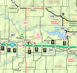
Major highways
The city of Russell is the junction of Interstate 70, a major east-west highway through the Midwestern United States, and U.S. Route 281, which begins at the Canada–US border in North Dakota and ends at the Mexico–US border in Texas. I-70 also runs through Gorham on the western end of the county and Dorrance on the eastern end. Hays is 27 miles (43 km) west of Russell and Salina is 67 miles (108 km) east of Russell.
Further along I-70, Russell is approximately 250 miles (400 km) west of Kansas City, Missouri and 360 miles (580 km) east of Denver, Colorado.
K-18, a major east-west state highway in northern Kansas, enters from Osborne County to the west and runs through Paradise before joining up with US 281 through Waldo. US 281 and K-18 split again at the city limits of Luray, and K-18 continues east through Lucas and into Lincoln County. US 281 heads north into Osborne County.
South of I-70, US 281 heads into Barton County and towards the city of Great Bend.
Demographics
| Historical population | |||
|---|---|---|---|
| Census | Pop. | %± | |
| 1870 | 156 | — | |
| 1880 | 7,351 | 4,612.2% | |
| 1890 | 7,333 | −0.2% | |
| 1900 | 8,489 | 15.8% | |
| 1910 | 10,800 | 27.2% | |
| 1920 | 10,748 | −0.5% | |
| 1930 | 11,045 | 2.8% | |
| 1940 | 13,464 | 21.9% | |
| 1950 | 13,406 | −0.4% | |
| 1960 | 11,348 | −15.4% | |
| 1970 | 9,428 | −16.9% | |
| 1980 | 8,868 | −5.9% | |
| 1990 | 7,835 | −11.6% | |
| 2000 | 7,370 | −5.9% | |
| 2010 | 6,970 | −5.4% | |
| Est. 2015 | 7,039 | [4] | 1.0% |
| U.S. Decennial Census[5] 1790-1960[6] 1900-1990[7] 1990-2000[8] 2010-2013[1] | |||

As of the census[9] of 2000, there were 7,370 people, 3,207 households, and 2,020 families residing in the county. The population density was 8 people per square mile (3/km²). There were 3,871 housing units at an average density of 4 per square mile (2/km²). The racial makeup of the county was 97.58% White, 0.50% Black or African American, 0.56% Native American, 0.33% Asian, 0.01% Pacific Islander, 0.27% from other races, and 0.75% from two or more races. 0.91% of the population were Hispanic or Latino of any race.
There were 3,207 households out of which 25.40% had children under the age of 18 living with them, 53.40% were married couples living together, 7.10% had a female householder with no husband present, and 37.00% were non-families. 32.80% of all households were made up of individuals and 16.80% had someone living alone who was 65 years of age or older. The average household size was 2.23 and the average family size was 2.83.
In the county the population was spread out with 22.40% under the age of 18, 5.80% from 18 to 24, 23.30% from 25 to 44, 24.30% from 45 to 64, and 24.10% who were 65 years of age or older. The median age was 44 years. For every 100 females there were 92.50 males. For every 100 females age 18 and over, there were 88.70 males.
The median income for a household in the county was $29,284, and the median income for a family was $40,355. Males had a median income of $25,916 versus $17,957 for females. The per capita income for the county was $17,073. About 9.10% of families and 12.00% of the population were below the poverty line, including 13.80% of those under age 18 and 8.50% of those age 65 or over.
Law and government
Russell County was a prohibition, or "dry", county until the Kansas Constitution was amended in 1986 and voters approved the sale of alcoholic liquor by the individual drink with a 30% food sales requirement.[10]
Education
Schools in Russell County have experienced major change in the 2010-11 school year. USD 407, which previously served all of Russell County except the northwest and southeast corners, retracted its footprint and will only serve the cities of Russell, Gorham and Bunker Hill and areas to the south of Interstate 70 along and adjacent to US 281.
Lucas-Luray High School, previously operated by USD 407, was acquired by the school district in Sylvan Grove in western Lincoln County and will be converted into a K-6 school. Meanwhile, the elementary school in Luray has closed. Students in Lucas and Luray in grades 7-12 will attend school in Sylvan Grove.
Unified school districts
- Central Plains USD 112 (serves Dorrance and southeastern part of county south of I-70; extends into Barton, Ellsworth and Rice Counties)
- Sylvan-Lucas Unified USD 299 (serves Lucas, Luray and northeast part of county along K-18; extends into Lincoln County)
- Natoma/Paradise/Waldo USD 399 (serves Paradise, Waldo and northwest part of county along K-18; extends into Osborne and Rooks Counties)
- Russell USD 407 (serves cities of Russell, Gorham, Bunker Hill and rural south central and southwest parts of county; does not extend into any other counties)
Communities
Cities
Townships
Russell County is divided into twelve townships. The city of Russell is considered governmentally independent and is excluded from the census figures for the townships. In the following table, the population center is the largest city (or cities) included in that township's population total, if it is of a significant size.
| Township | FIPS | Population center |
Population | Population density /km² (/sq mi) |
Land area km² (sq mi) | Water area km² (sq mi) | Water % | Geographic coordinates |
|---|---|---|---|---|---|---|---|---|
| Big Creek | 06700 | Gorham | 515 | 3 (7) | 186 (72) | 0 (0) | 0.03% | 38°51′40″N 98°59′8″W / 38.86111°N 98.98556°W |
| Center | 12150 | Bunker Hill | 255 | 1 (2) | 359 (139) | 9 (3) | 2.41% | 38°51′7″N 98°40′29″W / 38.85194°N 98.67472°W |
| Fairfield | 22200 | 42 | 0 (1) | 104 (40) | 0 (0) | 0.03% | 38°44′37″N 98°46′0″W / 38.74361°N 98.76667°W | |
| Fairview | 22650 | Lucas | 526 | 3 (7) | 185 (71) | 1 (1) | 0.77% | 39°2′16″N 98°31′54″W / 39.03778°N 98.53167°W |
| Grant | 28100 | 159 | 1 (3) | 135 (52) | 0 (0) | 0.18% | 38°49′41″N 98°50′31″W / 38.82806°N 98.84194°W | |
| Lincoln | 41125 | Milberger | 147 | 2 (4) | 94 (36) | 0 (0) | 0% | 38°44′40″N 98°51′54″W / 38.74444°N 98.86500°W |
| Luray | 43275 | Luray | 270 | 1 (4) | 183 (71) | 2 (1) | 0.94% | 39°5′6″N 98°40′3″W / 39.08500°N 98.66750°W |
| Paradise | 54350 | Paradise | 169 | 0 (1) | 372 (144) | 1 (0) | 0.16% | 39°3′9″N 98°55′31″W / 39.05250°N 98.92528°W |
| Plymouth | 56925 | Dorrance | 319 | 1 (3) | 255 (98) | 24 (9) | 8.50% | 38°50′46″N 98°33′4″W / 38.84611°N 98.55111°W |
| Russell | 61850 | 89 | 1 (2) | 127 (49) | 0 (0) | 0.03% | 38°54′40″N 98°51′27″W / 38.91111°N 98.85750°W | |
| Waldo | 74600 | Waldo | 108 | 1 (2) | 186 (72) | 0 (0) | 0.19% | 39°3′10″N 98°46′14″W / 39.05278°N 98.77056°W |
| Winterset | 80125 | 75 | 1 (2) | 93 (36) | 0 (0) | 0.05% | 38°44′15″N 98°59′30″W / 38.73750°N 98.99167°W |
See also
|
|
Further reading
- Russell County
- Russell County in the War : Being a Record of the War Activities of the County and the Part that it Played in the Great Struggle; John E. Wilson; Capper Printing; 190 pages; 1921. (Download 11MB PDF eBook)
- Plat Book of Russell County, Kansas; North West Publishing Co; 47 pages; 1901.
- Kansas
- History of the State of Kansas; William G. Cutler; A.T. Andreas Publisher; 1883. (Online HTML eBook)
- Kansas : A Cyclopedia of State History, Embracing Events, Institutions, Industries, Counties, Cities, Towns, Prominent Persons, Etc; 3 Volumes; Frank W. Blackmar; Standard Publishing Co; 944 / 955 / 824 pages; 1912. (Volume1 - Download 54MB PDF eBook), (Volume2 - Download 53MB PDF eBook), (Volume3 - Download 33MB PDF eBook)
- Trails
- Guide Map of the Best and Shortest Cattle Trail to the Kansas Pacific Railway; Kansas Pacific Railway Company; 1875. (Read Online)(Map)
References
- 1 2 "State & County QuickFacts". United States Census Bureau. Retrieved July 28, 2014.
- ↑ "Find a County". National Association of Counties. Retrieved 2011-06-07.
- ↑ "US Gazetteer files: 2010, 2000, and 1990". United States Census Bureau. 2011-02-12. Retrieved 2011-04-23.
- ↑ "County Totals Dataset: Population, Population Change and Estimated Components of Population Change: April 1, 2010 to July 1, 2015". Retrieved July 2, 2016.
- ↑ "U.S. Decennial Census". United States Census Bureau. Retrieved July 28, 2014.
- ↑ "Historical Census Browser". University of Virginia Library. Retrieved July 28, 2014.
- ↑ "Population of Counties by Decennial Census: 1900 to 1990". United States Census Bureau. Retrieved July 28, 2014.
- ↑ "Census 2000 PHC-T-4. Ranking Tables for Counties: 1990 and 2000" (PDF). United States Census Bureau. Retrieved July 28, 2014.
- ↑ "American FactFinder". United States Census Bureau. Retrieved 2008-01-31.
- ↑ "Map of Wet and Dry Counties". Alcoholic Beverage Control, Kansas Department of Revenue. November 2006. Retrieved 2007-12-28.
External links
| Wikimedia Commons has media related to Russell County, Kansas. |
- County
- Other
- Russell County Fair, held the first week of August
- Maps
- Russell County Maps: Current, Historic, KDOT
- Kansas Highway Maps: Current, Historic, KDOT
- Kansas Railroad Maps: Current, 1996, 1915, KDOT and Kansas Historical Society
 |
Osborne County | | ||
| Ellis County | |
Lincoln County | ||
| ||||
| | ||||
| Rush County | Barton County | Ellsworth County |
Municipalities and communities of Russell County, Kansas, United States | ||
|---|---|---|
| Cities | | |
| Townships | ||
| Unincorporated communities | ||
| Footnotes | ‡This populated place also has portions in an adjacent county or counties | |