Bath, Maine
| Bath, Maine | ||
|---|---|---|
| City | ||
|
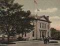
Bath City Hall | ||
| ||
| Nickname(s): City of Ships | ||
 Location of Bath in Maine | ||
 Bath, Maine Location in the United States | ||
| Coordinates: 43°54′59″N 69°49′21″W / 43.91639°N 69.82250°WCoordinates: 43°54′59″N 69°49′21″W / 43.91639°N 69.82250°W | ||
| Country | United States | |
| State | Maine | |
| County | Sagadahoc | |
| Incorporated (town) | February 17, 1781 | |
| Incorporated (city) | June 14, 1847 | |
| Area[1] | ||
| • Total | 13.22 sq mi (34.24 km2) | |
| • Land | 9.10 sq mi (23.57 km2) | |
| • Water | 4.12 sq mi (10.67 km2) | |
| Elevation | 62 ft (19 m) | |
| Population (2010)[2] | ||
| • Total | 8,514 | |
| • Estimate (2012[3]) | 8,408 | |
| • Density | 935.6/sq mi (361.2/km2) | |
| Time zone | Eastern (EST) (UTC-5) | |
| • Summer (DST) | EDT (UTC-4) | |
| ZIP code | 04530 | |
| Area code(s) | 207 | |
| FIPS code | 23-03355 | |
| GNIS feature ID | 0561723 | |
| Website | http://www.cityofbath.com/ | |
_City_Hall.jpg)

Bath is a city in Sagadahoc County, Maine, in the United States. The population was 8,514 at the 2010 census, and 8,357 as of 2013, the population has had a change of -10.2% since 2000. It is the county seat of Sagadahoc County, Which includes one city and 10 towns.[4] The city is popular with tourists, many drawn by its 19th-century architecture. It is home to the Bath Iron Works and Heritage Days Festival, held annually on the Fourth of July weekend. It is commonly known as "The City of Ships." Bath is part of the metropolitan statistical area of Greater Portland.
History
Abenaki Indians called the area Sagadahoc, meaning "mouth of big river." It was a reference to the Kennebec River, which Samuel de Champlain explored in 1605. Popham Colony was established in 1607 downstream, together with Fort St George. The settlement failed due to harsh weather and lack of leadership, but the colonists built the New World's first oceangoing vessel constructed by English shipwrights, the Virginia of Sagadahoc. It provided passage back to England. Most of Bath, Maine, was settled by travelers from Bath, England.[5]
The next settlement at Sagadahoc was about 1660, when the land was taken from an Indian sagamore known as Robinhood.[6] Incorporated as part of Georgetown in 1753, Bath was set off and incorporated as a town on February 17, 1781. It was named by the postmaster, Dummer Sewell, after Bath in Somerset, England. In 1844, a portion of the town was set off to create West Bath. On June 14, 1847, Bath was incorporated as a city, and in 1854 designated county seat. Land was annexed from West Bath in 1855.[5]
Several industries developed in the city, including lumber, iron and brass, with trade in ice and coal. But Bath is renowned for shipbuilding, which began here in 1743 when Jonathan Philbrook and his sons built 2 vessels. Since then, roughly 5,000 vessels have been launched in the area, which at one time had more than 200 shipbuilding firms. Bath became the nation's fifth largest seaport by the mid-19th century, producing clipper ships that sailed to ports around the world.[7] The last commercial enterprise to build wooden ships in the city was the Percy & Small Shipyard, which was acquired for preservation in 1971 by the Maine Maritime Museum. But the most famous shipyard is the Bath Iron Works, founded in 1884 by Thomas W. Hyde whom was also became the general manager of it in 1888. It has built hundreds of wooden and steel vessels, mostly warships for the U.S. Navy.[6] During World War II, Bath Iron Works launched a new ship an average of every 17 days. The shipyard is a major regional employer, and operates today as a division of the General Dynamics Corporation.
The city is noted for its Federal, Greek Revival, and Italianate architecture, including the 1858 Custom House and Post Office designed by Ammi B. Young. Bath is sister city to Shariki (now Tsugaru) in Japan, where the locally-built full rigged ship Cheseborough was wrecked in 1889. Scenes from the movies Message in a Bottle (1999) and The Man Without a Face (1993) were filmed in the city.[8]
-

Waterfront in 1907
-

Front Street c. 1920
-
Custom House c. 1905
Geography
Bath is located at 43°54′59″N 69°49′21″W / 43.91639°N 69.82250°W (43.916293, -69.822565).[9]
According to the United States Census Bureau, the city has a total area of 13.22 square miles (34.24 km2), of which, 9.10 square miles (23.57 km2) is land and 4.12 square miles (10.67 km2) is water.[1]
Greenspace
The city of Bath includes several nature preserves that are protected by the Kennebec Estuary Land Trust. These areas include, Thorne Head Preserve (located 2.1 miles north of Bath,) Butler Head Preserve (location 5.2 miles north of Bath,) there are also numerous multiple parks, and walking trails located throughout the town such as the Whiskeag Trail.
Demographics
| Historical population | |||
|---|---|---|---|
| Census | Pop. | %± | |
| 1790 | 949 | — | |
| 1800 | 1,225 | 29.1% | |
| 1810 | 2,491 | 103.3% | |
| 1820 | 3,026 | 21.5% | |
| 1830 | 3,773 | 24.7% | |
| 1840 | 5,141 | 36.3% | |
| 1850 | 8,020 | 56.0% | |
| 1860 | 8,076 | 0.7% | |
| 1870 | 7,371 | −8.7% | |
| 1880 | 7,874 | 6.8% | |
| 1890 | 8,723 | 10.8% | |
| 1900 | 10,477 | 20.1% | |
| 1910 | 9,396 | −10.3% | |
| 1920 | 14,731 | 56.8% | |
| 1930 | 9,110 | −38.2% | |
| 1940 | 10,235 | 12.3% | |
| 1950 | 10,644 | 4.0% | |
| 1960 | 10,717 | 0.7% | |
| 1970 | 9,679 | −9.7% | |
| 1980 | 10,246 | 5.9% | |
| 1990 | 9,799 | −4.4% | |
| 2000 | 9,266 | −5.4% | |
| 2010 | 8,514 | −8.1% | |
| Est. 2015 | 8,305 | [10] | −2.5% |
| sources:[11] | |||
2010 census
As of the census[2] of 2010, there were 8,514 people, 3,932 households, and 2,172 families residing in the city. The population density was 935.6 inhabitants per square mile (361.2/km2). There were 4,437 housing units at an average density of 487.6 per square mile (188.3/km2). The racial makeup of the city was 95.1% White, 1.2% African American, 0.3% Native American, 0.6% Asian, 0.4% from other races, and 2.3% from two or more races. Hispanic or Latino of any race were 1.8% of the population.
There were 3,932 households of which 27.5% had children under the age of 18 living with them, 37.5% were married couples living together, 13.6% had a female householder with no husband present, 4.2% had a male householder with no wife present, and 44.8% were non-families. 36.1% of all households were made up of individuals and 13.9% had someone living alone who was 65 years of age or older. The average household size was 2.14 and the average family size was 2.79.
The median age in the city was 41 years. 22.2% of residents were under the age of 18; 8.1% were between the ages of 18 and 24; 24.7% were from 25 to 44; 28.5% were from 45 to 64; and 16.5% were 65 years of age or older. The gender makeup of the city was 46.7% male and 53.3% female.
2000 census
As of the census[12] of 2000, there were 9,266 people, 4,042 households, and 2,344 families residing in the city. The population density was 1,016.8 people per square mile (392.7/km²). There were 4,383 housing units at an average density of 481.0 per square mile (185.8/km²). The racial makeup of the city was 94.92% White, 1.60% Black or African American, 0.58% Native American, 0.47% Asian, 0.13% Pacific Islander, 0.68% from other races, and 1.62% from two or more races. Hispanic or Latino of any race were 1.76% of the population.
There were 4,042 households out of which 29.7% had children under the age of 18 living with them, 40.8% were married couples living together, 13.1% had a female householder with no husband present, and 42.0% were non-families. 34.1% of all households were made up of individuals and 13.0% had someone living alone who was 65 years of age or older. The average household size was 2.26 and the average family size was 2.91.
In the city the population was spread out with 25.0% under the age of 18, 8.4% from 18 to 24, 29.5% from 25 to 44, 23.0% from 45 to 64, and 14.1% who were 65 years of age or older. The median age was 37 years. For every 100 females there were 91.4 males. For every 100 females age 18 and over, there were 86.9 males.
The median household income in the city was $36,372, and the median family income was $45,830. Males had a median income of $35,064 versus $22,439 for females. The per capita income for the city was $19,112. About 9.3% of families and 11.8% of the population were below the poverty line, including 17.5% of those under age 18 and 9.6% of those age 65 or over.
2013 Voter registration
Maine requires voters to register with a party to vote in primaries.
| Voter Registration and Party Enrollment as of August 30, 2013[13] | |||||
|---|---|---|---|---|---|
| Party | Total Voters | Percentage | |||
| Unenrolled | 2,425 | 36.93% | |||
| Democratic | 2,275 | 34.64% | |||
| Republican | 1,614 | 24.85% | |||
| Green Independent | 252 | 3.83% | |||
| Total | 6,566 | 100% | |||
Education

- RSU 1
- Dike-Newell Elementary, grades K-2
- Fisher-Mitchell Elementary, grades 3-5
- Bath Middle School — serves 430 students in grades 6-8 as of 2006. The school's mascot is the Destroyers, a type of ship built by the Bath Iron Works. The school colors are blue and white.
- Morse High School — The Morse High Shipbuilders (team). Sports include Cross Country, Football, Soccer, Cheerleading, Swimming, Basketball, Wrestling, Tennis, Indoor/Outdoor Track & Field, Lacrosse, Softball, Baseball. Clubs include the International Club, Ambassadors Club, Debate team, and more. The school colors are blue and white. In 2020 a new school will be fully constructed [14]
 Morse High School
- Hyde School, a college preparatory school - serves 149 students in grades 9-12 as of 2012. The school's mascot is the Phoenix. The school colors are navy blue and gold.[15]
- Southern Maine Community College at Bath
- University College at Bath/Brunswick
Library
Notable people
Climate
| Climate data for Bath, Maine | |||||||||||||
|---|---|---|---|---|---|---|---|---|---|---|---|---|---|
| Month | Jan | Feb | Mar | Apr | May | Jun | Jul | Aug | Sep | Oct | Nov | Dec | Year |
| Record high °F (°C) | 61 (16) |
59 (15) |
73 (23) |
84 (29) |
94 (34) |
100 (38) |
98 (37) |
104 (40) |
95 (35) |
85 (29) |
74 (23) |
68 (20) |
104 (40) |
| Average high °F (°C) | 31 (−1) |
34 (1) |
43 (6) |
54 (12) |
65 (18) |
74 (23) |
80 (27) |
79 (26) |
70 (21) |
59 (15) |
48 (9) |
37 (3) |
56.2 (13.3) |
| Average low °F (°C) | 10 (−12) |
14 (−10) |
23 (−5) |
33 (1) |
43 (6) |
52 (11) |
58 (14) |
57 (14) |
48 (9) |
37 (3) |
29 (−2) |
17 (−8) |
35.1 (1.8) |
| Record low °F (°C) | −49 (−45) |
−25 (−32) |
−10 (−23) |
13 (−11) |
27 (−3) |
34 (1) |
37 (3) |
37 (3) |
28 (−2) |
18 (−8) |
1 (−17) |
−21 (−29) |
−49 (−45) |
| Average precipitation inches (mm) | 4.06 (103.1) |
3.57 (90.7) |
4.55 (115.6) |
4.47 (113.5) |
4.11 (104.4) |
3.57 (90.7) |
3.31 (84.1) |
3.15 (80) |
3.71 (94.2) |
4.19 (106.4) |
4.87 (123.7) |
4.47 (113.5) |
48.03 (1,220) |
| Source: [16] | |||||||||||||
Sites of interest


- Maine Eastern Railroad
- Chocolate Church Arts Center
- Maine Maritime Museum
- Studio Theatre of Bath
- Bath Skate Park
- Bath Municipal Band
Sister cities
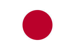 Tsugaru, Aomori, Japan[17]
References
- 1 2 "US Gazetteer files 2010". United States Census Bureau. Archived from the original on 2012-01-24. Retrieved 2012-11-23.
- 1 2 "American FactFinder". United States Census Bureau. Retrieved 2012-11-23.
- ↑ "Population Estimates". United States Census Bureau. Archived from the original on 2013-06-17. Retrieved 2013-07-05.
- ↑ "Find a County". National Association of Counties. Archived from the original on 2012-07-12. Retrieved 2011-06-07.
- 1 2 Coolidge, Austin J.; John B. Mansfield (1859). A History and Description of New England. Boston, Massachusetts. pp. 48–50.
- 1 2 Prins, Harald E. L. (1996). "Chief Rawandagon Alias Robin Hood: Native 'Lord of Misrule' in the Maine Wilderness". In Grumet, Robert. Northeastern Indian Lives, 1632-1816. Amherst, Ma: University of Massachusetts Press. pp. 93–115.
- ↑ "Historical Sketch of Bath Maine". rays-place.com.
- ↑ "Bath, Sagadahoc County, Maine". rootsweb.com.
- ↑ "US Gazetteer files: 2010, 2000, and 1990". United States Census Bureau. 2011-02-12. Retrieved 2011-04-23.
- ↑ "Annual Estimates of the Resident Population for Incorporated Places: April 1, 2010 to July 1, 2015". Retrieved July 2, 2016.
- ↑ "Maine Census Data Population Totals: Sagadahoc County". Fogler Library. Archived from the original on 2011-07-20.
- ↑ "American FactFinder". United States Census Bureau. Archived from the original on 2013-09-11. Retrieved 2008-01-31.
- ↑ "REGISTERED & ENROLLED VOTERS - STATEWIDE" (PDF). August 30, 2013. Retrieved 27 October 2013.
- ↑ http://mhsathletics.blogs.rsu1.org/
- ↑ http://www.hyde.edu/about/
- ↑ "Average Weather for Bath, ME - Temperature and Precipitation". Weather.com. Retrieved August 27, 2010.
- ↑ "US-Japan Sister Cities by State". Asia Matters for America. Honolulu, HI: East-West Center. Retrieved 20 November 2015.
Further reading
- History of Bath and Environs, Sagadahoc County, Maine, 1607-1894. By Parker McCobb Reed. Published 1894. Full image at books.google.
- History of Destroyers at Bath Iron Works
External links
| Wikimedia Commons has media related to Bath, Maine. |
| Wikisource has the text of The New Student's Reference Work article Bath, Me.. |
- City of Bath, Maine
- Patten Free Library
- Bath Historical Society
- Sagadahoc Preservation, Inc.
- Main Street Bath
- Aerial photo
- Maine's First Ship -- Reconstructing the Virginia
Municipalities and communities of Sagadahoc County, Maine, United States | ||
|---|---|---|
| City |  | |
| Towns | ||
| Unorganized territory | ||
| CDPs | ||
| Other village | ||
Augusta (capital) | |
| Topics |
|
| Society |
|
| Regions | |
| Counties | |
| Cities | |
| Largest towns | |