Whiteson, Oregon
| Whiteson | |
|---|---|
| Unincorporated community | |
|
Whiteson Road and field in Whiteson | |
 Whiteson  Whiteson Location within the state of Oregon | |
| Coordinates: 45°9′6″N 123°11′44″W / 45.15167°N 123.19556°WCoordinates: 45°9′6″N 123°11′44″W / 45.15167°N 123.19556°W | |
| Country | United States |
| State | Oregon |
| County | Yamhill |
| Time zone | Pacific (PST) (UTC-8) |
| • Summer (DST) | PDT (UTC-7) |

Whiteson is an unincorporated community in Yamhill County, Oregon, United States. Oregon Geographic Names states that Whiteson is named for either for Henry White, who laid out the town site and gave the railroad right-of-way, or for William White. It is possible they are members of the same family. Whiteson post office was established in 1890.
Geography
Whiteson is located 3 miles south of McMinnville, on Oregon Route 99W, near Whiteson Dip Bridge.
Climate
This region experiences warm (but not hot) and dry summers, with no average monthly temperatures above 71.6 °F. According to the Köppen Climate Classification system, Whiteson has a warm-summer Mediterranean climate, abbreviated "Csb" on climate maps.[1]
Education
Whiteson School District 78 was established in 1892, and the first one-room schoolhouse was finished in the March 1893. In 1903 the decision was made to create an addition to the Whiteson school, making it a two-room school. 1936 was the last year school was taught here, before the district finally consolidated with Amity School District 4, in 1942.[2]
References
- ↑ Climate Summary for Whiteson, Oregon
- ↑ Schools of Old Yamhill. Lafayette, Oregon: Yamhill County Historical Society. 1982.
Municipalities and communities of Yamhill County, Oregon, United States | ||
|---|---|---|
| Cities | 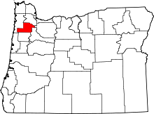 | |
| CDPs | ||
| Other unincorporated communities |
| |
| Indian reservation | ||
| Footnotes | ‡This populated place also has portions in an adjacent county or counties | |