White Pine Haven, Wisconsin
| White Pine Haven, Wisconsin | |
|---|---|
| Unincorporated community | |
 White Pine Haven, Wisconsin  White Pine Haven, Wisconsin | |
| Coordinates: 45°33′49″N 87°47′40″W / 45.56361°N 87.79444°WCoordinates: 45°33′49″N 87°47′40″W / 45.56361°N 87.79444°W | |
| Country | United States |
| State | Wisconsin |
| County | Marinette |
| Elevation | 761 ft (232 m) |
| Time zone | Central (CST) (UTC-6) |
| • Summer (DST) | CDT (UTC-5) |
| Area code(s) | 715 & 534 |
| GNIS feature ID | 1876876[1] |
White Pine Haven is an unincorporated community located in the town of Beecher, Marinette County, Wisconsin, United States. White Pine Haven is located on the Menominee River at the Michigan border, 18 miles (29 km) southeast of Niagara.
References
Municipalities and communities of Marinette County, Wisconsin, United States | ||
|---|---|---|
| Cities | 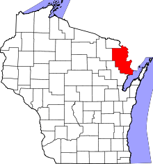 | |
| Villages | ||
| Towns | ||
| CDPs | ||
| Unincorporated communities | ||
| Footnotes | ‡This populated place also has portions in an adjacent county or counties | |
This article is issued from Wikipedia - version of the 7/29/2016. The text is available under the Creative Commons Attribution/Share Alike but additional terms may apply for the media files.