Walnut Township, Jewell County, Kansas
| Walnut Township | |
|---|---|
| Township | |
 Location in Jewell County | |
| Coordinates: 39°57′28″N 98°19′51″W / 39.95778°N 98.33083°WCoordinates: 39°57′28″N 98°19′51″W / 39.95778°N 98.33083°W | |
| Country | United States |
| State | Kansas |
| County | Jewell |
| Area | |
| • Total | 39.46 sq mi (102.21 km2) |
| • Land | 39.44 sq mi (102.14 km2) |
| • Water | 0.03 sq mi (0.07 km2) 0.07% |
| Elevation | 1,818 ft (554 m) |
| Population (2000) | |
| • Total | 80 |
| • Density | 2/sq mi (0.8/km2) |
| GNIS feature ID | 0471850 |
Walnut Township is a township in Jewell County, Kansas, USA. As of the 2000 census, its population was 80.
Geography
Walnut Township covers an area of 39.46 square miles (102.21 square kilometers); of this, 0.03 square miles (0.07 square kilometers) or 0.07 percent is water.
Unincorporated towns
- Northbranch
(This list is based on USGS data and may include former settlements.)
Adjacent townships
- Harrison Township (east)
- Holmwood Township (southeast)
- Burr Oak Township (south)
- White Mound Township (southwest)
- Highland Township (west)
Major highways
- K-128
References
External links
Municipalities and communities of Jewell County, Kansas, United States | ||
|---|---|---|
| Cities | 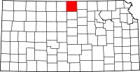 | |
| Unincorporated communities | ||
| Townships | ||
This article is issued from Wikipedia - version of the 11/11/2013. The text is available under the Creative Commons Attribution/Share Alike but additional terms may apply for the media files.