Wabash Township, Tippecanoe County, Indiana
| Wabash Township | |
|---|---|
| Township | |
|
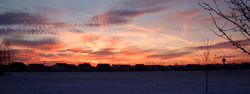
Dawn skies over a West Lafayette neighborhood | |
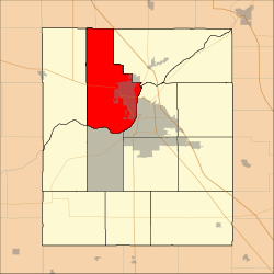 Location in Tippecanoe County | |
| Coordinates: 40°28′20″N 86°57′15″W / 40.47222°N 86.95417°WCoordinates: 40°28′20″N 86°57′15″W / 40.47222°N 86.95417°W | |
| Country | United States |
| State | Indiana |
| County | Tippecanoe |
| Government | |
| • Type | Indiana township |
| • Trustee | Julia (Julie) Byers |
| • Board | Jared Bond |
| • Board | Mike Oxenrider |
| • Board | Dale Workman |
| Area | |
| • Total | 49.1 sq mi (127 km2) |
| • Land | 48.65 sq mi (126.0 km2) |
| • Water | 0.46 sq mi (1.2 km2) 0.94% |
| Elevation | 659 ft (201 m) |
| Population (2010) | |
| • Total | 59,279 |
| • Density | 1,218.5/sq mi (470.5/km2) |
| ZIP codes | 47906 |
| Area code(s) | 765 |
| GNIS feature ID | 453967 |
Wabash Township is one of thirteen townships in Tippecanoe County, Indiana, United States. As of the 2010 census, its population was 59,279 and it contained 21,448 housing units making it the most populous township in Tippecanoe County.[1]
Geography
According to the 2010 census, the township has a total area of 49.1 square miles (127 km2), of which 48.65 square miles (126.0 km2) (or 99.08%) is land and 0.46 square miles (1.2 km2) (or 0.94%) is water.[1] Wabash Township encompasses all but a small section of the City of West Lafayette and encompasses all of Purdue University making it one of the most culturally diverse townships in the United States.
| Climate data for Wabash Township, Tippecanoe County, Indiana | |||||||||||||
|---|---|---|---|---|---|---|---|---|---|---|---|---|---|
| Month | Jan | Feb | Mar | Apr | May | Jun | Jul | Aug | Sep | Oct | Nov | Dec | Year |
| Record high °F (°C) | 69 (21) |
73 (23) |
86 (30) |
89 (32) |
94 (34) |
105 (41) |
105 (41) |
100 (38) |
98 (37) |
92 (33) |
78 (26) |
73 (23) |
105 (41) |
| Average high °F (°C) | 34 (1) |
39 (4) |
50 (10) |
63 (17) |
73 (23) |
83 (28) |
85 (29) |
84 (29) |
78 (26) |
65 (18) |
51 (11) |
38 (3) |
61.9 (16.6) |
| Average low °F (°C) | 19 (−7) |
23 (−5) |
31 (−1) |
41 (5) |
51 (11) |
61 (16) |
64 (18) |
63 (17) |
55 (13) |
44 (7) |
34 (1) |
23 (−5) |
42.4 (5.8) |
| Record low °F (°C) | −23 (−31) |
−20 (−29) |
−3 (−19) |
7 (−14) |
25 (−4) |
35 (2) |
43 (6) |
37 (3) |
29 (−2) |
19 (−7) |
6 (−14) |
−16 (−27) |
−23 (−31) |
| Average precipitation inches (mm) | 1.86 (47.2) |
1.84 (46.7) |
2.67 (67.8) |
3.54 (89.9) |
4.19 (106.4) |
4.10 (104.1) |
3.97 (100.8) |
3.46 (87.9) |
2.66 (67.6) |
2.89 (73.4) |
2.97 (75.4) |
2.51 (63.8) |
36.66 (931.2) |
| Average snowfall inches (cm) | 6.5 (16.5) |
4.8 (12.2) |
2.9 (7.4) |
0.7 (1.8) |
0 (0) |
0 (0) |
0 (0) |
0 (0) |
0 (0) |
0.3 (0.8) |
0.8 (2) |
5.2 (13.2) |
21.2 (53.8) |
| Average precipitation days (≥ 0.01 in) | 9.6 | 7.7 | 10.2 | 10.9 | 10.6 | 10.4 | 8.9 | 8.4 | 7.6 | 8.3 | 9.8 | 10.1 | 112.5 |
| Average snowy days (≥ 0.1 in) | 5.3 | 3.3 | 1.7 | 0.3 | 0 | 0 | 0 | 0 | 0 | 0.1 | 0.9 | 3.5 | 15.1 |
| Source #1: The Weather Channel (January record high)[2] | |||||||||||||
| Source #2: NOAA: Lafayette[3] | |||||||||||||
Cities, towns, villages
- West Lafayette (vast majority)
Unincorporated towns
- Bar Barry Heights
- Crumb Corner
- Green Meadows
- Happy Hollow Heights
- Indian Village
- Klondike
- McQuinn Estates
- Octagon
- Ravinamy
- Summit
- Wabash Shores
(This list is based on USGS data and may include former settlements.)
Adjacent townships
- Prairie Township, White County (northeast)
- Tippecanoe Township (northeast)
- Fairfield Township (southeast)
- Union Township (south)
- Wayne Township (southwest)
- Shelby Township (west)
- Round Grove Township, White County (northwest)
Cemeteries
The township contains five cemeteries: Grandview, Hebron, Indiana State Soldiers' Home, Sand Ridge and Tippecanoe Memory Gardens.
Major highways
Airports

Lakes
- Hadley Lake
- Celery Bog Nature Area
Landmarks
- Purdue University
- C-SPAN Archives
- Fort Ouiatenon A former French trading post built in the early 1700s.
- Samara House - Samara is a house designed by Frank Lloyd Wright.
- Indiana State Soldiers Home Historic District, Levi and Lucy Morehouse Farm, and James Pierce Jr. House are listed on the National Register of Historic Places.[4][5]
News and Media
- WLFI-TV is a CBS affiliate owned by LIN Media.
- WBAA is a radio station owned by Purdue University.
- Purdue Exponent is a daily independent student run newspaper.
School districts
Political districts
- Indiana's 4th congressional district
- State House District 26
- State House District 27
- State Senate District 22
Township Officials
Township Trustee
- Julia (Julie) Byers
Township Board
- Jared Bond
- Mike Oxenrider
- Dale Workman
References
- United States Census Bureau 2007 TIGER/Line Shapefiles
- United States Board on Geographic Names (GNIS)
- United States National Atlas
- 1 2 "Population, Housing Units, Area, and Density: 2010 - County -- County Subdivision and Place -- 2010 Census Summary File 1". United States Census. Retrieved 2013-05-10.
- ↑ "Monthly Averages for Lafayette, IN (47905)". The Weather Channel. Retrieved June 13, 2014.
- ↑ "Climatology of the United States No. 20: LAFAYETTE 8 S, IN 1971–2000" (PDF). National Oceanic and Atmospheric Administration. Retrieved November 19, 2011.
- ↑ National Park Service (2010-07-09). "National Register Information System". National Register of Historic Places. National Park Service.
- ↑ "National Register of Historic Places Listings". Weekly List of Actions Taken on Properties: 12/17/12 through 12/21/12. National Park Service. 2012-12-28.
External links
Municipalities and communities of Tippecanoe County, Indiana, United States | ||
|---|---|---|
| Cities | ||
| Towns | ||
| Townships | ||
| CDPs | ||
| Other unincorporated communities |
| |
| Ghost towns | ||
| Footnotes | ‡This populated place also has portions in an adjacent county or counties | |