Shadeland, Indiana
| Shadeland | |
|---|---|
| Town | |
|
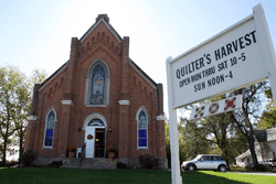
The old church building along State Road 25 in Shadeland | |
 | |
| Coordinates: 40°22′24″N 86°56′57″W / 40.37333°N 86.94917°WCoordinates: 40°22′24″N 86°56′57″W / 40.37333°N 86.94917°W | |
| Country | United States |
| State | Indiana |
| County | Tippecanoe |
| Townships | Union |
| Area[1] | |
| • Total | 27.33 sq mi (70.78 km2) |
| • Land | 27.10 sq mi (70.19 km2) |
| • Water | 0.23 sq mi (0.60 km2) |
| Elevation[2] | 620 ft (189 m) |
| Population (2010)[3] | |
| • Total | 1,610 |
| • Estimate (2012[4]) | 1,684 |
| • Density | 59.4/sq mi (22.9/km2) |
| Time zone | EST (UTC-5) |
| • Summer (DST) | EDT (UTC-4) |
| ZIP code | 47909 |
| Area code(s) | 765 |
| FIPS code | 18-68868[5] |
| GNIS feature ID | 443237 |
| Website | http://www.shadeland.in.gov/ |
Shadeland is a town in Tippecanoe County, Indiana, United States.[6] The population was 1,610 at the 2010 census.
It is part of the Lafayette, Indiana Metropolitan Statistical Area.
History
A post office was established at Shadeland in 1887, and remained in operation until it was discontinued in 1915.[7]
Farmers Institute and Stidham United Methodist Church are listed on the National Register of Historic Places.[8]
Geography
Shadeland is located at 40°22′24″N 86°56′57″W / 40.37333°N 86.94917°W (40.373210, -86.949180) and has an elevation of approximately 620 feet. Indiana State Road 25 passes east and west through town.
The town is coextensive with Union Township in Tippecanoe County. The township chose to incorporate in order to prevent partial or total annexation by neighboring Lafayette. According to the 2010 census, Shadeland has a total area of 27.332 square miles (70.79 km2), of which 27.1 square miles (70.19 km2) (or 99.15%) is land and 0.232 square miles (0.60 km2) (or 0.85%) is water.[1]
Demographics
| Historical population | |||
|---|---|---|---|
| Census | Pop. | %± | |
| 1990 | 1,674 | — | |
| 2000 | 1,682 | 0.5% | |
| 2010 | 1,610 | −4.3% | |
| Est. 2015 | 1,784 | [9] | 10.8% |
2010 census
As of the census[3] of 2010, there were 1,610 people, 616 households, and 476 families residing in the town. The population density was 59.4 inhabitants per square mile (22.9/km2). There were 675 housing units at an average density of 24.9 per square mile (9.6/km2). The racial makeup of the town was 96.0% White, 0.4% African American, 0.6% Native American, 0.5% Asian, 0.1% Pacific Islander, 1.4% from other races, and 1.0% from two or more races. Hispanic or Latino of any race were 3.3% of the population.
There were 616 households of which 30.5% had children under the age of 18 living with them, 62.2% were married couples living together, 10.1% had a female householder with no husband present, 5.0% had a male householder with no wife present, and 22.7% were non-families. 17.4% of all households were made up of individuals and 6.8% had someone living alone who was 65 years of age or older. The average household size was 2.61 and the average family size was 2.94.
The median age in the town was 43.2 years. 21.8% of residents were under the age of 18; 8.3% were between the ages of 18 and 24; 22.2% were from 25 to 44; 33.9% were from 45 to 64; and 13.8% were 65 years of age or older. The gender makeup of the town was 49.2% male and 50.8% female.
2000 census
As of the census[5] of 2000, there were 1,682 people, 602 households, and 471 families residing in the town. The population density was 62.0 people per square mile (23.9/km²). There were 676 housing units at an average density of 24.9 per square mile (9.6/km²). The racial makeup of the town was 97.44% White, 0.30% African American, 0.18% Native American, 0.77% Asian, 0.71% from other races, and 0.59% from two or more races. Hispanic or Latino of any race were 2.97% of the population.
There were 602 households out of which 36.9% had children under the age of 18 living with them, 66.4% were married couples living together, 5.3% had a female householder with no husband present, and 21.6% were non-families. 16.9% of all households were made up of individuals and 6.1% had someone living alone who was 65 years of age or older. The average household size was 2.79 and the average family size was 3.15.
In the town the population was spread out with 27.6% under the age of 18, 7.6% from 18 to 24, 27.5% from 25 to 44, 28.7% from 45 to 64, and 8.7% who were 65 years of age or older. The median age was 38 years. For every 100 females there were 107.9 males. For every 100 females age 18 and over, there were 104.4 males.
The median income for a household in the town was $48,750, and the median income for a family was $56,875. Males had a median income of $36,810 versus $23,897 for females. The per capita income for the town was $20,631. About 1.9% of families and 3.1% of the population were below the poverty line, including 1.1% of those under age 18 and 5.4% of those age 65 or over.
References
- 1 2 "G001 - Geographic Identifiers - 2010 Census Summary File 1". United States Census Bureau. Retrieved 2015-07-25.
- ↑ "US Board on Geographic Names". United States Geological Survey. 2007-10-25. Retrieved 2008-01-31.
- 1 2 "American FactFinder". United States Census Bureau. Retrieved 2012-12-11.
- ↑ "Population Estimates". United States Census Bureau. Retrieved 2013-06-25.
- 1 2 "American FactFinder". United States Census Bureau. Retrieved 2008-01-31.
- ↑ "Shadeland, Indiana". Geographic Names Information System. United States Geological Survey. Retrieved 2016-07-25.
- ↑ "Tippecanoe County". Jim Forte Postal History. Retrieved July 25, 2016.
- ↑ National Park Service (2010-07-09). "National Register Information System". National Register of Historic Places. National Park Service.
- ↑ "Annual Estimates of the Resident Population for Incorporated Places: April 1, 2010 to July 1, 2015". Retrieved July 2, 2016.
- ↑ "Census of Population and Housing". Census.gov. Retrieved June 4, 2015.
External links
Municipalities and communities of Tippecanoe County, Indiana, United States | ||
|---|---|---|
| Cities | ||
| Towns | ||
| Townships | ||
| CDPs | ||
| Other unincorporated communities |
| |
| Ghost towns | ||
| Footnotes | ‡This populated place also has portions in an adjacent county or counties | |