Thatta
Coordinates: 24°44′46.02″N 67°55′27.61″E / 24.7461167°N 67.9243361°E
| Thatta ٺٽو (Sindhi) ننگر ٺٽو | |
|---|---|
| City | |
|
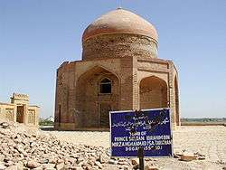
A tomb at Makli Hills necropolis built in 1559 | |
| Nickname(s): The City of Silence | |
 Thatta ٺٽو (Sindhi) Location in Sindh, Pakistan | |
| Coordinates: 24°44′46.02″N 67°55′27.61″E / 24.7461167°N 67.9243361°E | |
| Country | Pakistan |
| Province | Sindh |
| District | Thatta District |
| Population | |
| • Total | 220,000 |
| Time zone | PST (UTC+5) |
Thatta (Sindhi: ٺٽو; is a city and capital of Thatta District. It will be capital of the announced Banbhore Division.[1] It is a historic town of 220,000 inhabitants in the Sindh province of Pakistan, near Lake Keenjhar, the largest freshwater lake in the country.
Thatta's major monument, the necropolis at Makli Hill, is listed among the World Heritage Sites.[2] The Shah Jahan Mosque, Thatta is mentioned separately on the tentative list since 1993.[3] Located 100 km (62 mi) east of the provincial capital of Sindh, Karachi, it makes for a practical escape for people from the city seeking to visit the picturesque old town.
History
Thatta may be the site of ancient Patala (Πάταλα in Greek), the main port on the Indus in the time of Alexander the Great.[4] The site of Patala has been subject to much debate. Ahmad Hasan Dani, director of the Taxila Institute of Asian Civilisations, Islamabad, concluded: “There has been a vain attempt to identify the city of Patala. If ‘Patala’ is not taken as a proper name but only refers to a city, it can be corrected to ‘Pattana’, that is, city or port city par excellence, a term applied in a later period to Thatta, which is ideally situated in the way the Greek historians describe”.[5] Herbert Wilhelmy has pointed out that siltation had caused the Indus to change its course many times over the centuries and that in Alexander’s time it bifurcated at the site of Bahmanabad, 75 km to the northeast of Hyderabad, which John Watson McCrindle had considered to occupy the site of ancient Patala.[6]
The geographer Strabo (c.64 BC–c.24 AD) recorded that: “The Indus falls into the southern sea by two mouths, encompassing the country of Patalênê, which resembles the Delta in Egypt”.[7] He noted: “All these [nations] were conquered by Alexander, and last of all he reduced Patalênê, which the Indus forms by splitting into two branches… Patalênê contains a considerable city, Patala, which gives its name to the island”.[8] In the late second century BC Agatharchides of Cnidus recorded merchants from Patala, or as he called it, “Potana”, coming to the island of Socotra to trade with Alexandrian merchants.[9]
The city, formerly commanding the delta of the Indus, was the capital of Lower Sindh from the 14th century onwards. Some suggested the name derived from the word Thab implying closeness of population, while others find its origin in the common word Thatta, a crowd or assembly of people. The city was destroyed by Mirza Jani Beg in the 16th century.[10] During the Samma dynasty, Thatta was the capital of Sindh for 95 years. Between 1592 and 1739, it was governed in the name of the Mughal emperors of Delhi. In 1739, however, following the Battle of Karnal, the province was ceded to Nadir Shah of Persia, after which Thatta fell into neglect as the Indus river started to silt up.
Between 1652 and 1660, the Dutch East India Company had a small tradingpost (comptoir or factory) in Thatta.[11] This competed with the English one, which was established in 1635 and closed in 1662. A second British 'factory' was set up during the Kalhora period, in 1758, which lasted until 1775.[12] In the early 19th century Thatta had declined to a population of about 18,000. To the Arabs it was known as Dibal and the remnants of the brick wall from the Mirza Isa Tarkhan period were visible at that time.[10]
Thatta or Banbhore division
On 23 April 2014, the People's Party government announced to form Sindh's sixth division Banbhore Division with Thatta as capital.[13][14] These sources reveal that this formation is made to improve governance in Thatta.[15]
Climate
.[16]
Climate of Thatta:
The average annual rainfall is 210mm, The average annual temperature in Thatta is 26.8 °C.
Monthly rainfall:
January: 5mm, February: 8mm, March 5mm, April: 3mm, May: 5mm, June: 17mm, July: 98mm, August: 50mm, September: 15mm, October: 1mm, November: 2mm, December 3mm.
See also
References
- ↑ http://tribune.com.pk/story/699913/the-sixth-welcome-bhanbhor-sindhs-latest-administrative-division/
- ↑ WHS Thatta World Heritage site, Retrieved 2010-12-27.
- ↑ Shah Jahan Mosque UNESCO World Heritage Centre. Retrieved 10 February 2011
- ↑ James Rennell, Memoir of a map of Hindoostan:or the Mogul's Empire, London, 1783, p.57; William Vincent, The Voyage of Nearchus from the Indus to the Euphrates, London, 1797, p.146; William Robertson, An Historical Disquisition concerning the Knowledge which the Ancients had of India, A. Strahan, T. Cadell Jun. and W. Davies; and E. Balfour, Edinburgh, 1799, p.47; Alexander Burnes, Travels into Bokhara: containing the narrative of a voyage on the Indus [...] and an account of a journey from India to Cabool, Tartary, and Persia, London, John Murray, 1835, Volume 1, p.27; Carl Ritter, Die Erdkunde im Verhältniss zur Natur und zur Geschichte des Menschen, Berlin, Reimer, 1835, Band IV, Fünfter Theil, pp.475–476.
- ↑ A.H. Dani and P. Bernard, “Alexander and His Successors in Central Asia”, in János Harmatta, B.N. Puri and G.F. Etemadi (editors), History of civilizations of Central Asia, Paris, UNESCO, Vol.II, 1994, p.85.
- ↑ Herbert Wilhelmy, “Verschollene Städte im Indusdelta“, Geographische Zeitschrift, Bd.56, heft 4, 1968, pp.256–294, n.b. pp.258–63; John Watson McCrindle, Ancient India as described in Classical Literature, Westminster, Constable, 1901, pp.19, 40, 124, 188; idem, The Invasion of India by Alexander the Great, Westminster, Constable, 1893, pp.356–7).
- ↑ Strabo, Geography, bk.XV, c.13; quoted in John Watson McCrindle, Ancient India as described in Classical Literature, being a Collection of Greek and Latin Texts relating to India, Westminster, Constable, 1901, p.19.
- ↑ Strabo, Geography, bk.XV, c.33; quoted in McCrindle, 1901, p.40.
- ↑ Agatharchides of Cnidus, On the Erythraean Sea, translated and edited by Stanley M. Burstein, London, Hakluyt Society, 1989, p.169.
- 1 2 Ali, Mubarak 1994. McMurdo's & Delhoste's account of Sindh Takhleeqat, Lahore, p. 28-29.
- ↑ Floor, Willem, 1993-4. The Dutch East India Company (VOC) and Diewel-Sind (Pakistan) in the 17th and 18th centuries. Institute of Central & West Asian Studies, University of Karachi.
- ↑ Ali,Mubarak, 2005. The English Factory in Sindh, Zahoor Ahmed Khan Fiction House, Lahore
- ↑ abbtakk.tv/.../94282indh-govt-declares-thatta-sixth-division-of-province...
- ↑ http://www.thenewstribe.com/2014/04/24/thatta-declares-as-division-of-sindh/
- ↑ videos.arynews.tv/sindh-government-promoted-thatta-division/
- ↑ Pakistan flood victims flee Thatta. Guardian, Retrieved 2010-12-27.
External links
-
 Thatta travel guide from Wikivoyage
 - Shah Jahan Mosque - Thatta
- Makli Necropolis - Thatta
| |||||||||||||||||||||||||||||||||
| |||||||||||||||||||||||||||||||||
| |||||||||||||||||||||||||||||||||
| |||||||||||||||||||||||||||||||||
| |||||||||||||||||||||||||||||||||
| |||||||||||||||||||||||||||||||||