Sycamore Township, Butler County, Kansas
| Sycamore Township | |
|---|---|
| Township | |
 Location in Butler County | |
| Coordinates: 38°01′40″N 096°39′26″W / 38.02778°N 96.65722°WCoordinates: 38°01′40″N 096°39′26″W / 38.02778°N 96.65722°W | |
| Country | United States |
| State | Kansas |
| County | Butler |
| Area | |
| • Total | 114.67 sq mi (297.01 km2) |
| • Land | 113.8 sq mi (294.75 km2) |
| • Water | 0.87 sq mi (2.26 km2) 0.76% |
| Elevation | 1,457 ft (444 m) |
| Population (2000) | |
| • Total | 333 |
| • Density | 2.9/sq mi (1.1/km2) |
| GNIS feature ID | 0474399 |
| Website | County Website |
Sycamore Township is a township in Butler County, Kansas, USA. As of the 2000 census, its population was 333.
History
Sycamore Township was organized in 1871. It was named for a large sycamore tree which has long since blown over.[1]
Geography
Sycamore Township covers an area of 114.67 square miles (297.0 km2) and contains one incorporated settlement, Cassoday. According to the USGS, it contains one cemetery, Cassoday. The stream of School Branch runs through this township.
Further reading
References
- ↑ Mooney, Vol. P. (1916). History of Butler County Kansas. Standard Publishing Company. p. 217.
External links
- Butler County Website
- City-Data.com
- Butler County Maps: Current, 1936
 |
Milton Township (Marion County) | Cedar Township (Chase County) | (Chase County) | |
| Lincoln Township | |
(Greenwood County) | ||
| ||||
| | ||||
| Lincoln Township | Chelsea Township | (Greenwood County) |
Municipalities and communities of Butler County, Kansas, United States | ||
|---|---|---|
| Cities | 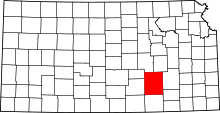 | |
| CDP | ||
| Unincorporated communities | ||
| Ghost towns | ||
| Townships | ||
| Footnotes | ‡This populated place also has portions in an adjacent county or counties | |
This article is issued from Wikipedia - version of the 11/1/2016. The text is available under the Creative Commons Attribution/Share Alike but additional terms may apply for the media files.