Sugar Loaf Township, Boone County, Arkansas
| Sugar Loaf Township | |
|---|---|
| Township | |
 Sugar Loaf Township Location in Arkansas | |
| Coordinates: 36°24′52.87″N 92°58′3.37″W / 36.4146861°N 92.9676028°WCoordinates: 36°24′52.87″N 92°58′3.37″W / 36.4146861°N 92.9676028°W | |
| Country |
|
| State |
|
| County | Boone |
| Area | |
| • Total | 93.832 sq mi (243.02 km2) |
| • Land | 84.026 sq mi (217.63 km2) |
| • Water | 9.806 sq mi (25.40 km2) |
| Population (2010) | |
| • Total | 2,320 |
| • Density | 27.61/sq mi (10.66/km2) |
| Time zone | CST (UTC-6) |
| • Summer (DST) | CDT (UTC-5) |
| Zip Code | 72644 (Lead Hill), 72630 (Diamond City) |
| Area code(s) | 870 |
Sugar Loaf Township is one of twenty current townships in Boone County, Arkansas, USA.[1] As of the 2010 census, its total population was 2,320.
Geography
According to the United States Census Bureau, Sugar Loaf Township covers an area of 93.832 square miles (243.02 km2); 84.026 square miles (217.63 km2) of land and 9.806 square miles (25.40 km2) of water.
Cities, towns, and villages
Population history
The township was located in Carroll County for the 1850 and 1860 censuses. Population includes the incorporated city of Diamond City and the incorporated towns of Lead Hill and South Lead Hill.
| Historical population | |||
|---|---|---|---|
| Census | Pop. | %± | |
| 1850 | 226 | — | |
| 1860 | 269 | 19.0% | |
| 1870 | 827 | 207.4% | |
| 1880 | 1,370 | 65.7% | |
| 1890 | 1,712 | 25.0% | |
| 1900 | 1,518 | −11.3% | |
| 1910 | 1,032 | −32.0% | |
| 1920 | 1,239 | 20.1% | |
| 1930 | 1,077 | −13.1% | |
| 1940 | 833 | −22.7% | |
| 1950 | 587 | −29.5% | |
| 1960 | 591 | 0.7% | |
| 1970 | 1,016 | 71.9% | |
| 1980 | 1,632 | 60.6% | |
| 1990 | 1,774 | 8.7% | |
| 2000 | 2,028 | 14.3% | |
| 2010 | 2,320 | 14.4% | |
References
- United States Census Bureau 2008 TIGER/Line Shapefiles
- United States Board on Geographic Names (GNIS)
- United States National Atlas
- ↑ "Sugar Loaf Township, Boone County, Arkansas." U.S. Census Bureau. Breakdown. Retrieved June 1, 2012.
External links
Municipalities and communities of Boone County, Arkansas, United States | ||
|---|---|---|
| Cities | 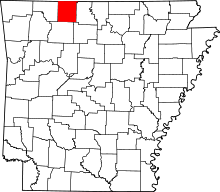 | |
| Towns | ||
| Townships | ||
| Unincorporated communities | ||
| Ghost town | ||
| Footnotes | ‡This populated place also has portions in an adjacent county or counties | |
This article is issued from Wikipedia - version of the 9/10/2013. The text is available under the Creative Commons Attribution/Share Alike but additional terms may apply for the media files.