Songkhla
| Songkhla สงขลา | |
|---|---|
| City | |
|
City of Songkhla | |
 Songkhla | |
| Coordinates: 7°12′22″N 100°35′48″E / 7.20611°N 100.59667°E | |
| Country |
|
| Provinces | Songkhla Province |
| Amphoe | Mueang Songkhla District |
| Elevation | 11 m (36 ft) |
| Population (2006) | 75,048 |
| Time zone | ICT (UTC+7) |


Songkhla (Thai: สงขลา, pronounced [sǒŋ.kʰlǎː]), also known as Singgora or Singora (Pattani Malay: ซิงกอรา), is a city (thesaban nakhon) in Songkhla Province of southern Thailand, near the border with Malaysia. As of 2006 it had a population of 75,048. Songkhla lies 968 km south of Bangkok.[1]
Despite being smaller than the neighboring city Hat Yai, Songkhla is the capital of Songkhla Province as well as the Mueang Songkhla district (Songkhla town district).
Due to its location at the opening of Songkhla Lake to the Gulf of Thailand, Songkhla is a fishing town and also an important harbour. It is the major seaport on the east side of the Isthmus of Kra.
History


On 8 December 1941 local time, hours before the 7 December (Hawaii time) attack on Pearl Harbor, the Imperial Japanese army landed here, invading Thailand. It then moved south towards Perlis and Penang as part of the Malayan campaign which culminated in the capture of Singapore.[2]
Since 2003, Songhkla has been affected by Muslim insurgencies in neighboring Narathiwat, Pattani, and Yala.[3]
The municipality's mayor, Peera Tantiserane, was murdered there in 2012.[4]
Climate
Songkhla has a tropical monsoon climate (Köppen climate classification Am). Temperatures are very warm to hot throughout the year with only minor variation. There is a short dry season in February and March; the rest of the year is wet, with especially heavy rainfall from October to December.
| Climate data for Songkhla (1981–2010) | |||||||||||||
|---|---|---|---|---|---|---|---|---|---|---|---|---|---|
| Month | Jan | Feb | Mar | Apr | May | Jun | Jul | Aug | Sep | Oct | Nov | Dec | Year |
| Record high °C (°F) | 32.4 (90.3) |
34.3 (93.7) |
35.3 (95.5) |
36.8 (98.2) |
38.6 (101.5) |
37.1 (98.8) |
36.6 (97.9) |
37.3 (99.1) |
35.8 (96.4) |
38.5 (101.3) |
34.0 (93.2) |
32.6 (90.7) |
38.6 (101.5) |
| Average high °C (°F) | 29.6 (85.3) |
30.3 (86.5) |
31.4 (88.5) |
32.5 (90.5) |
33.0 (91.4) |
33.1 (91.6) |
32.9 (91.2) |
33.0 (91.4) |
32.3 (90.1) |
31.4 (88.5) |
29.8 (85.6) |
29.2 (84.6) |
31.5 (88.7) |
| Daily mean °C (°F) | 27.1 (80.8) |
27.5 (81.5) |
28.1 (82.6) |
28.9 (84) |
28.8 (83.8) |
28.6 (83.5) |
28.3 (82.9) |
28.2 (82.8) |
27.8 (82) |
27.3 (81.1) |
26.9 (80.4) |
26.7 (80.1) |
27.9 (82.2) |
| Average low °C (°F) | 24.7 (76.5) |
24.7 (76.5) |
25.0 (77) |
25.4 (77.7) |
25.4 (77.7) |
25.1 (77.2) |
24.8 (76.6) |
24.7 (76.5) |
24.5 (76.1) |
24.3 (75.7) |
24.3 (75.7) |
24.4 (75.9) |
24.8 (76.6) |
| Record low °C (°F) | 20.8 (69.4) |
20.4 (68.7) |
19.7 (67.5) |
21.1 (70) |
22.1 (71.8) |
21.1 (70) |
21.1 (70) |
21.9 (71.4) |
21.4 (70.5) |
21.1 (70) |
20.4 (68.7) |
20.7 (69.3) |
19.7 (67.5) |
| Average rainfall mm (inches) | 74.8 (2.945) |
48.6 (1.913) |
59.7 (2.35) |
75.1 (2.957) |
119.6 (4.709) |
99.9 (3.933) |
95.0 (3.74) |
109.4 (4.307) |
136.9 (5.39) |
257.1 (10.122) |
545.9 (21.492) |
444.7 (17.508) |
2,066.7 (81.366) |
| Average rainy days | 10.0 | 5.3 | 7.1 | 8.5 | 13.0 | 13.2 | 12.7 | 13.8 | 15.5 | 19.9 | 22.6 | 20.4 | 162.0 |
| Average relative humidity (%) | 78 | 77 | 78 | 78 | 78 | 77 | 77 | 76 | 79 | 82 | 84 | 82 | 79 |
| Mean monthly sunshine hours | 179.8 | 183.6 | 204.6 | 201.0 | 151.9 | 150.0 | 151.9 | 151.9 | 144.0 | 111.6 | 105.0 | 142.6 | 1,877.9 |
| Mean daily sunshine hours | 5.8 | 6.5 | 6.6 | 6.7 | 4.9 | 5.0 | 4.9 | 4.9 | 4.8 | 3.6 | 3.5 | 4.6 | 5.2 |
| Source #1: Thai Meteorological Department[5] | |||||||||||||
| Source #2: Office of Water Management and Hydrology, Royal Irrigation Department (sun and humidity)[6] | |||||||||||||
Population
The majority of the population is Buddhist with a large proportion of Muslims, especially in the rural areas fringing the Malaysian border. These Muslims speak Yawi language, a Malay-related language which has some Thai influence especially loan words borrowed from the Thai language.[7]
Songkhla's district (amphoe) has five Tambon Administrative Organizations (องค์การบริหารส่วนตำบล). Songkhla town takes up the whole of Bo Yang division.
| No. | Name | Thai | Villages | Inhab. | |
|---|---|---|---|---|---|
| 1. | Bo Yang | บ่อยาง | - | 74,875 | |
| 2. | Khao Rup Chang | เขารูปช้าง | 10 | 38,662 | |
| 3. | Ko Taeo | เกาะแต้ว | 9 | 10,608 | |
| 4. | Phawong | พะวง | 8 | 24,130 | |
| 5. | Thung Wang | ทุ่งหวัง | 10 | 10,343 | |
| 6. | Ko Yo | เกาะยอ | 9 | 4,454 |
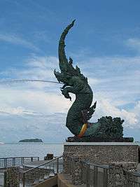
Gallery
 Songkhla mermaid
 Tinsulanonda Bridge
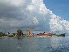 Songkhla Sea Port
 Songkhla Lak Mueang
 Malay family in Songkhla
See also
References
- ↑ "Distance: Bangkok to Songkhla". Google Maps. Retrieved 23 May 2015.
- ↑ Parfitt, Allen. "Bicycle Blitzkreig [sic] The Japanese Conquest of Malaya and Singapore 1941-1942". MilitaryHistoryOnline.com. Retrieved 9 Aug 2012.
- ↑ Saritdet Marukatat, Signs of new hope in South
- ↑ "'Hitman' sought in Peera murder". Bangkokpost.com. 2012-11-13. Retrieved 2013-02-20.
- ↑ "Climatological Data for the Period 1981–2010". Thai Meteorological Department. p. 25. Retrieved 8 August 2016.
- ↑ "ปริมาณการใช้น้ำของพืชอ้างอิงโดยวิธีของ Penman Monteith (Reference Crop Evapotranspiration by Penman Monteith)" (PDF) (in Thai). Office of Water Management and Hydrology, Royal Irrigation Department. p. 121. Retrieved 8 August 2016.
- ↑ Moshe Yegar, ''Between Integration and Secession''. Books.google.co.th. 2002. ISBN 9780739103562. Retrieved 2013-02-20.
External links
 Songkhla travel guide from Wikivoyage
| Wikimedia Commons has media related to Songkhla. |
- Official website (Thai)
Coordinates: 7°12′22″N 100°35′48″E / 7.20611°N 100.59667°E
| ||