Nong Khai
| Nong Khai หนองคาย | |
|---|---|
| Town | |
|
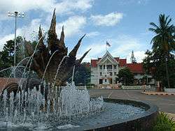
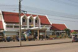
Nong Khai Old City Hall, Nong Khai City | |
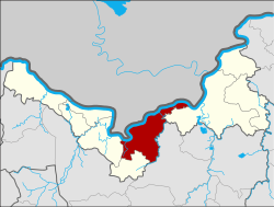 Location in Nong Khai Province | |
| Country | Thailand |
| Province | Nong Khai Province |
| Area | |
| • Total | 31.15 km2 (12.03 sq mi) |
| Population (2011) | |
| • Total | 46,180 |
| • Density | 1,500/km2 (3,800/sq mi) |
| Time zone | ICT (UTC+7) |
Nong Khai (เทศบาลเมืองหนองคาย, Thesaban Mueang Nong Khai (Nong Khai Town) or หนองคาย or Nong Khai) is a city in north-east Thailand. It is the capital of Nong Khai Province. Nong Khai city is administered as Amphoe Mueang Nong Khai.
Nong Khai lies on the Mekong River, near the site of the first Thai-Lao Friendship Bridge, spanning the river to Laos. The Thai-Lao Friendship bridge was largely funded by a gift to the Lao government from the Australian government.[1] It is the road and railway gateway to Laos's capital, Vientiane, 25 kilometers upriver, on the north bank opposite the Thai town of Sri Chiang Mai. Construction of a rail spur to Thanaleng outside of Vientiane was begun early-2007 and officially opened 5 March 2009.[2]
Nong Khai is 626 km north of Bangkok[3] and 60 km north of Udon Thani.[4]
History
The Prap Ho Monument before the old city hall (now a museum and cultural center) memorialises the dead of the Haw wars[5] and, down by the Mekong, as does Wat Angkhan (Thai: วัดอังคาร), which is Pali for "ashes of the dead". Nearby, the city maintains the Garden of Sorrows (Thai: สวนโศกเศร้า), with signs signifying this is where widows came to grieve.
In more recent years, Nong Khai has become a popular destination during the Buddhist Lent festival when mysterious balls of light, or Naga fireballs, rise from the Mekong River. The balls resemble an orange sun. They rise out of the river approximately 6–9 meters (20 to 30 feet) and disappear after three to five seconds. Although the fireballs can be seen at other times, most Thais travel to see them during the full moon in October when the incidence of them is considered to be much higher.[6]
Nong Khai's main sight is Sala Keoku (alternatively spelled as Sala Kaew Ku, also known as Wat Khaek), a park of colossal sculptures, some over 20 m tall. The park is the handiwork of the mystic Luang Pu Bunleua Sulilat, who bought the land in 1978 when he was exiled from his native Laos, where he had built a similar park in Vientiane in the 1950s. Synthesizing Buddhist and Hinduist ideologies, Buddhas, many-armed goddesses, a seven-headed Naga snake, and various human-animal hybrids dominate the site.[7]
Climate
| Climate data for Nong Khai (1981–2010) | |||||||||||||
|---|---|---|---|---|---|---|---|---|---|---|---|---|---|
| Month | Jan | Feb | Mar | Apr | May | Jun | Jul | Aug | Sep | Oct | Nov | Dec | Year |
| Record high °C (°F) | 37.3 (99.1) |
39.1 (102.4) |
42.8 (109) |
43.3 (109.9) |
42.8 (109) |
39.5 (103.1) |
37.4 (99.3) |
37.5 (99.5) |
36.2 (97.2) |
36.0 (96.8) |
36.6 (97.9) |
35.8 (96.4) |
43.3 (109.9) |
| Average high °C (°F) | 29.7 (85.5) |
32.1 (89.8) |
34.7 (94.5) |
36.2 (97.2) |
34.2 (93.6) |
33.0 (91.4) |
32.4 (90.3) |
31.9 (89.4) |
31.9 (89.4) |
31.8 (89.2) |
30.6 (87.1) |
28.9 (84) |
32.3 (90.1) |
| Daily mean °C (°F) | 22.5 (72.5) |
24.9 (76.8) |
27.6 (81.7) |
29.5 (85.1) |
28.6 (83.5) |
28.2 (82.8) |
27.8 (82) |
27.5 (81.5) |
27.4 (81.3) |
26.7 (80.1) |
24.6 (76.3) |
22.1 (71.8) |
26.5 (79.7) |
| Average low °C (°F) | 16.8 (62.2) |
19.1 (66.4) |
21.9 (71.4) |
24.3 (75.7) |
24.7 (76.5) |
24.9 (76.8) |
24.7 (76.5) |
24.5 (76.1) |
24.1 (75.4) |
22.9 (73.2) |
19.8 (67.6) |
16.5 (61.7) |
22.0 (71.6) |
| Record low °C (°F) | 8.0 (46.4) |
9.6 (49.3) |
10.2 (50.4) |
17.3 (63.1) |
20.0 (68) |
20.9 (69.6) |
19.8 (67.6) |
21.0 (69.8) |
20.5 (68.9) |
14.2 (57.6) |
8.8 (47.8) |
4.9 (40.8) |
4.9 (40.8) |
| Average rainfall mm (inches) | 8.3 (0.327) |
17.3 (0.681) |
39.8 (1.567) |
83.4 (3.283) |
224.9 (8.854) |
262.3 (10.327) |
281.4 (11.079) |
323.2 (12.724) |
257.2 (10.126) |
90.9 (3.579) |
15.2 (0.598) |
4.3 (0.169) |
1,608.2 (63.315) |
| Average rainy days | 1.6 | 3.1 | 5.5 | 8.4 | 17.1 | 19.7 | 20.8 | 22.4 | 18.2 | 9.2 | 2.3 | 1.0 | 129.3 |
| Average relative humidity (%) | 69 | 66 | 64 | 67 | 78 | 83 | 84 | 85 | 83 | 78 | 71 | 69 | 75 |
| Mean monthly sunshine hours | 257.3 | 243.0 | 275.9 | 204.0 | 158.1 | 117.0 | 120.9 | 117.8 | 144.0 | 198.4 | 216.0 | 257.3 | 2,309.7 |
| Mean daily sunshine hours | 8.3 | 8.6 | 8.9 | 6.8 | 5.1 | 3.9 | 3.9 | 3.8 | 4.8 | 6.4 | 7.2 | 8.3 | 6.3 |
| Source #1: Thai Meteorological Department[8] | |||||||||||||
| Source #2: Office of Water Management and Hydrology, Royal Irrigation Department (sun and humidity)[9] | |||||||||||||
References
- ↑ Australian Govt Dept of Foreign Trade, Feb 9 2008, "Archived copy" (PDF). Archived from the original (PDF) on 2014-07-31. Retrieved 2014-11-11.,
- ↑ Spooner, Andrew (2009-02-27). "First Train to Laos". The Guardian. Retrieved 22 May 2015.
- ↑ "Distance: Bangkok to Nong Khai". Google Maps. Retrieved 22 May 2015.
- ↑ "Distance: Udon Thani to Nong Khai". Google Maps. Retrieved 22 May 2015.
- ↑ "Prap Ho Monument". Tourism Authority of Thailand (TAT). Retrieved 22 May 2015.
- ↑ "The Naga fireballs, Nong Khai". Tourism Authority of Thailand (TAT). Retrieved 22 May 2015.
- ↑ "Sala Kaeo Ku or Wat Khaek". Tourism Authority of Thailand (TAT). Retrieved 22 May 2015.
- ↑ "Climatological Data for the Period 1981–2010". Thai Meteorological Department. p. 8. Retrieved 1 August 2016.
- ↑ "ปริมาณการใช้น้ำของพืชอ้างอิงโดยวิธีของ Penman Monteith (Reference Crop Evapotranspiration by Penman Monteith)" (PDF) (in Thai). Office of Water Management and Hydrology, Royal Irrigation Department. p. 40. Retrieved 1 August 2016.
External links
| Wikimedia Commons has media related to Nong Khai. |
Coordinates: 17°52′5″N 102°44′40″E / 17.86806°N 102.74444°E
| ||