Chanthaburi
| Chanthaburi, Thailand | |
|---|---|
| Town | |
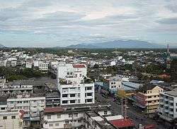 | |
 Chanthaburi, Thailand Location in Thailand | |
| Coordinates: 12°36′31″N 102°16′14″E / 12.60861°N 102.27056°E | |
| Country |
|
| Province | Chanthaburi Province |
| Districts of Thailand | Amphoe Mueang Chanthaburi |
| Elevation | 30 ft (10 m) |
| Population (2005) | |
| • Total | 27,602 |
Chanthaburi (Thai: จันทบุรี) is a town (thesaban mueang) in the east of Thailand, on the banks of the Chanthaburi River. It is the capital of the Chanthaburi Province and the Mueang Chanthaburi district.
The town covers the two tambons Talat and Wat Mai of Mueang Chanthaburi district. As of 2005, the town has a population of 27,602. The town figures in the legacy of King Taksin. In 1981 the Thai cabinet passed a resolution to bestow on him the honorary title of the Great; the Bank of Thailand issued the 12th Series of banknotes, called The Great Series. The monument of King Taksin the Great in the town's Tungnachaey recreational park appears on the back of the 20-Baht note issued December 28, 1981,[1] the 214th anniversary of his coronation.
Climate
Chanthaburi has a tropical monsoon climate (Köppen climate classification Am), with little variation in temperature throughout the year. Rainfall, however, varies dramatically by season; rainfall is light and infrequent in the short dry season (December to January), but the wet season (late April to October) features torrential rain. February, March and November are transitional months, during which significant rainfall may occur in some years, while in other years little rain falls.
| Climate data for Chanthaburi (1981–2010) | |||||||||||||
|---|---|---|---|---|---|---|---|---|---|---|---|---|---|
| Month | Jan | Feb | Mar | Apr | May | Jun | Jul | Aug | Sep | Oct | Nov | Dec | Year |
| Record high °C (°F) | 36.6 (97.9) |
36.3 (97.3) |
36.5 (97.7) |
36.5 (97.7) |
36.7 (98.1) |
35.0 (95) |
36.0 (96.8) |
35.7 (96.3) |
35.5 (95.9) |
35.6 (96.1) |
36.3 (97.3) |
35.5 (95.9) |
36.7 (98.1) |
| Average high °C (°F) | 32.6 (90.7) |
32.7 (90.9) |
33.1 (91.6) |
33.9 (93) |
32.8 (91) |
31.8 (89.2) |
31.3 (88.3) |
31.2 (88.2) |
31.4 (88.5) |
32.0 (89.6) |
32.1 (89.8) |
31.8 (89.2) |
32.2 (90) |
| Daily mean °C (°F) | 26.4 (79.5) |
27.3 (81.1) |
28.1 (82.6) |
28.7 (83.7) |
28.3 (82.9) |
27.9 (82.2) |
27.6 (81.7) |
27.5 (81.5) |
27.2 (81) |
27.0 (80.6) |
26.9 (80.4) |
26.0 (78.8) |
27.4 (81.3) |
| Average low °C (°F) | 21.5 (70.7) |
23.0 (73.4) |
24.0 (75.2) |
24.8 (76.6) |
25.1 (77.2) |
25.1 (77.2) |
24.8 (76.6) |
24.9 (76.8) |
24.4 (75.9) |
23.9 (75) |
23.1 (73.6) |
21.4 (70.5) |
23.8 (74.8) |
| Record low °C (°F) | 15.0 (59) |
16.5 (61.7) |
14.5 (58.1) |
21.4 (70.5) |
22.1 (71.8) |
21.9 (71.4) |
21.4 (70.5) |
21.4 (70.5) |
21.2 (70.2) |
18.7 (65.7) |
16.5 (61.7) |
13.1 (55.6) |
13.1 (55.6) |
| Average rainfall mm (inches) | 18.7 (0.736) |
36.4 (1.433) |
71.9 (2.831) |
125.2 (4.929) |
392.5 (15.453) |
512.6 (20.181) |
483.2 (19.024) |
497.2 (19.575) |
497.6 (19.591) |
297.6 (11.717) |
54.5 (2.146) |
6.8 (0.268) |
2,994.2 (117.882) |
| Average rainy days | 1.9 | 3.6 | 6.7 | 10.8 | 22.0 | 24.4 | 24.1 | 25.1 | 24.8 | 18.4 | 5.9 | 1.3 | 169.0 |
| Average relative humidity (%) | 69 | 74 | 77 | 78 | 83 | 84 | 84 | 85 | 86 | 82 | 72 | 66 | 78 |
| Mean monthly sunshine hours | 229.4 | 180.8 | 201.5 | 204.0 | 117.8 | 57.0 | 58.9 | 58.9 | 54.0 | 145.7 | 189.0 | 226.3 | 1,723.3 |
| Mean daily sunshine hours | 7.4 | 6.4 | 6.5 | 6.8 | 3.8 | 1.9 | 1.9 | 1.9 | 1.8 | 4.7 | 6.3 | 7.3 | 4.7 |
| Source #1: Thai Meteorological Department[2] | |||||||||||||
| Source #2: Office of Water Management and Hydrology, Royal Irrigation Department (sun and humidity)[3] | |||||||||||||

The Cathedral of the Immaculate Conception, the principal church of the Roman Catholic Diocese of Chanthaburi, is the largest church in Thailand.
Transportation
Route 3 (Sukhumvit Road) passes beside Chanthaburi and connects to city to Rayong, Pattaya, Chonburi, and Bangkok to the north-west and Trat to the south-east. Route 317 connects Chanthaburi to Sa Kaeo.
References
- ↑ Wararat; Sumit (February 23, 2012). "The Great Series". Banknotes > History and Series of Banknotes > Banknotes, Series 12. Bank of Thailand. Retrieved June 7, 2013.
20 Baht Back - Notification Date November 2, 1981 Issue Date December 28, 1981
- ↑ "Climatological Data for the Period 1981–2010". Thai Meteorological Department. p. 21. Retrieved 6 August 2016.
- ↑ "ปริมาณการใช้น้ำของพืชอ้างอิงโดยวิธีของ Penman Monteith (Reference Crop Evapotranspiration by Penman Monteith)" (PDF) (in Thai). Office of Water Management and Hydrology, Royal Irrigation Department. p. 100. Retrieved 6 August 2016.
External links
 Chanthaburi travel guide from Wikivoyage
| Wikimedia Commons has media related to Chanthaburi. |
Coordinates: 12°36′31″N 102°06′14″E / 12.60861°N 102.10389°E
| ||