Shire of Ararat
| Shire of Ararat Victoria | |||||||||||||
|---|---|---|---|---|---|---|---|---|---|---|---|---|---|
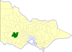 Location in Victoria | |||||||||||||
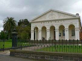 Former Shire Hall. Barkly Street, Ararat | |||||||||||||
| Population | 4,490 (1992)[1] | ||||||||||||
| • Density | 1.2278/km2 (3.180/sq mi) | ||||||||||||
| Established | 1861 | ||||||||||||
| Area | 3,657.06 km2 (1,412.0 sq mi) | ||||||||||||
| Council seat | Ararat | ||||||||||||
| County | Ripon, Borung | ||||||||||||
| |||||||||||||
The Shire of Ararat was a local government area located about 200 kilometres (124 mi) west-northwest of Melbourne, the state capital of Victoria, Australia. The shire covered an area of 3,657.06 square kilometres (1,412.0 sq mi), and existed from 1861 until 1994. The shire did not cover the town of Ararat, which was managed by a separate local government authority.
History
Ararat was first incorporated as a road district on 27 August 1861, and became a shire on 8 March 1864. Parts of its north riding were annexed to the Shire of Stawell on 26 October 1926, while other portions were annexed to the City of Ararat on 1 October 1941 and 27 May 1960.[2]
On 23 September 1994, the Shire of Ararat was abolished, and, along with the City of Ararat and parts of the Shire of Stawell, was merged into the newly created Rural City of Ararat.[3]
Wards
The Shire of Ararat was divided into four ridings, each of which elected three councillors:
- North Riding
- South Riding
- East Riding
- West Riding
Towns and localities
- Buangor
- Dunneworthy
- Elmhurst
- Lake Bolac
- Mafeking
- Maroona
- Mininera
- Moyston
- Norval
- Pomonal
- Rossbridge
- Streatham
- Tatyoon
- Warrak
- Westmere
- Wickliffe
- Willaura
- Yalla-y-Poora
Population
| Year | Population |
|---|---|
| 1954 | 4,659 |
| 1958 | 4,940* |
| 1961 | 4,600 |
| 1966 | 4,641 |
| 1971 | 4,178 |
| 1976 | 4,134 |
| 1981 | 4,135 |
| 1986 | 4,230 |
| 1991 | 4,278 |
* Estimate in the 1958 Victorian Year Book.
References
- ↑ Australian Bureau of Statistics, Victoria Office (1994). Victorian Year Book. pp. 49–52. ISSN 0067-1223.
- ↑ Victorian Municipal Directory. Brunswick: Arnall & Jackson. 1992. pp. 567–568. Accessed at State Library of Victoria, La Trobe Reading Room.
- ↑ Australian Bureau of Statistics (1 August 1995). Victorian local government amalgamations 1994-1995: Changes to the Australian Standard Geographical Classification (PDF). Commonwealth of Australia. p. 4. ISBN 0-642-23117-6. Retrieved 2008-01-05.
Coordinates: 37°20′S 142°48′E / 37.333°S 142.800°E