Schweinfurt (district)
| Schweinfurt | |
|---|---|
| District | |
 | |
| Country |
|
| State | Bavaria |
| Adm. region | Unterfranken |
| Capital | Schweinfurt |
| Area | |
| • Total | 842 km2 (325 sq mi) |
| Population (31 December 2015)[1] | |
| • Total | 114,813 |
| • Density | 140/km2 (350/sq mi) |
| Time zone | CET (UTC+1) |
| • Summer (DST) | CEST (UTC+2) |
| Vehicle registration | SW |
| Website | landkreis-schweinfurt.de |
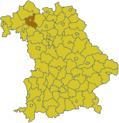
Schweinfurt is a Kreis (district) in the northwestern part of Bavaria, Germany. Neighboring districts are (from the north clockwise) Bad Kissingen, Rhön-Grabfeld, Haßberge, Bamberg, Kitzingen, Würzburg and Main-Spessart. The district-free city Schweinfurt is surrounded by the district.
Geography
Primary rivers in the district are the Main and the Wern. It is located between several hill chains - Haßberge to the east, the Rhön in the northwest, the Spessart to the west and the Steigerwald in the southeast.
History
The area of the district became part of Bavaria in 1814. In 1972 parts of the previous district Gerolzhofen (including the town Gerolzhofen) were merged with the district.
Coat of arms
 |
The coat of arms shows the imperial eagle in the top part as a symbol of the former imperial city Schweinfurt. The bottom part of the coat of arms shows the symbol of the clerical state of Würzburg, which ruled a big part of the district until 1803. |
Towns and municipalities
| Towns | Verwaltungsgemeinschaften | free municipalities |
|---|---|---|
|
Markt ¹ administrated within a |
|
|
References
- ↑ "Fortschreibung des Bevölkerungsstandes". Bayerisches Landesamt für Statistik und Datenverarbeitung (in German). June 2016.
External links
| Wikimedia Commons has media related to Landkreis Schweinfurt. |
- Official website (German)
- Schweinfurt-Online www.SW-ON.de Information about the city Schweinfurt and the district of Schweinfurt
Coordinates: 50°00′N 10°15′E / 50.0°N 10.25°E
