Saulgé
| Saulgé | |
|---|---|
|
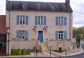
Town hall | |
 Saulgé | |
|
Location within Nouvelle-Aquitaine region  Saulgé | |
| Coordinates: 46°22′43″N 0°52′35″E / 46.3786°N 0.8764°ECoordinates: 46°22′43″N 0°52′35″E / 46.3786°N 0.8764°E | |
| Country | France |
| Region | Nouvelle-Aquitaine |
| Department | Vienne |
| Arrondissement | Montmorillon |
| Canton | Montmorillon |
| Intercommunality | Montmorillonnais |
| Government | |
| • Mayor (2014–2020) | Jacques Larrant |
| Area1 | 62.31 km2 (24.06 sq mi) |
| Population (2016)2 | 1,039 |
| • Density | 17/km2 (43/sq mi) |
| Time zone | CET (UTC+1) |
| • Summer (DST) | CEST (UTC+2) |
| INSEE/Postal code | 86254 / 86500 |
| Elevation |
87–202 m (285–663 ft) (avg. 100 m or 330 ft) |
|
1 French Land Register data, which excludes lakes, ponds, glaciers > 1 km² (0.386 sq mi or 247 acres) and river estuaries. 2 Population without double counting: residents of multiple communes (e.g., students and military personnel) only counted once. | |
Saulgé is a commune in the Vienne department in the Nouvelle-Aquitaine region in western France. The city is located 50 km southeast of Poitiers and 80 km northwest of Limoges.
See also
References
| Wikimedia Commons has media related to Saulgé. |
This article is issued from Wikipedia - version of the 11/11/2016. The text is available under the Creative Commons Attribution/Share Alike but additional terms may apply for the media files.