Saint-Mard, Seine-et-Marne
| Saint-Mard | |
|---|---|
|
The town hall of Saint-Mard | |
 | |
| Coordinates: 49°02′12″N 2°41′38″E / 49.0366°N 2.6939°ECoordinates: 49°02′12″N 2°41′38″E / 49.0366°N 2.6939°E | |
| Country | France |
| Region | Île-de-France |
| Department | Seine-et-Marne |
| Arrondissement | Meaux |
| Canton | Mitry-Mory |
| Intercommunality | Roissy Pays de France |
| Government | |
| • Mayor (2014–2020) | Daniel Dometz |
| Area1 | 6.26 km2 (2.42 sq mi) |
| Population (2013)2 | 3,841 |
| • Density | 610/km2 (1,600/sq mi) |
| Time zone | CET (UTC+1) |
| • Summer (DST) | CEST (UTC+2) |
| INSEE/Postal code | 77420 / 77230 |
| Elevation | 93–166 m (305–545 ft) |
|
1 French Land Register data, which excludes lakes, ponds, glaciers > 1 km² (0.386 sq mi or 247 acres) and river estuaries. 2 Population without double counting: residents of multiple communes (e.g., students and military personnel) only counted once. | |

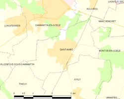
Saint-Mard is a commune in the Seine-et-Marne department in the Île-de-France region in north-central France.
Demographics
Inhabitants of Saint-Mard are called Mardochiens.
See also
References
External links
| Wikimedia Commons has media related to Saint-Mard (Seine-et-Marne). |
- 1999 Land Use, from IAURIF (Institute for Urban Planning and Development of the Paris-Île-de-France région) (English)
- Map of Saint-Mard on Michelin (English)
This article is issued from Wikipedia - version of the 9/20/2016. The text is available under the Creative Commons Attribution/Share Alike but additional terms may apply for the media files.