Rosemont–La Petite-Patrie
| Rosemont–La Petite-Patrie | ||
|---|---|---|
| Borough of Montreal | ||
|
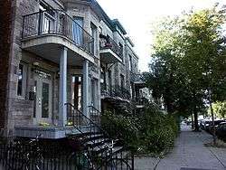
Saint Denis Street in the Rosemont neighbourhood. | ||
| ||
 Rosemont–La Petite-Patrie's location in Montreal | ||
| Coordinates: 45°32′1.4″N 73°36′46.8″W / 45.533722°N 73.613000°W | ||
| Country |
| |
| Province |
| |
| City | Montreal | |
| Region | Montréal | |
| Merge into Montreal | January 1, 2002 | |
| Electoral Districts Federal |
Rosemont—La Petite-Patrie Hochelaga Outremont | |
| Provincial |
Rosemont Gouin Hochelaga-Maisonneuve | |
| Government[1][2][3] | ||
| • Type | Borough | |
| • Mayor | François Croteau (PM) | |
| • Federal MP(s) |
Alexandre Boulerice (NDP) Marjolaine Boutin-Sweet (NDP) Thomas Mulcair (NDP) | |
| • Quebec MNA(s) |
Jean-François Lisée (PQ) Françoise David (QS) Carole Poirier (PQ) | |
| Area[4] | ||
| • Land | 15.9 km2 (6.1 sq mi) | |
| Population (2011) | ||
| • Total | 134,038 | |
| • Density | 8,456.7/km2 (21,903/sq mi) | |
| Time zone | Eastern (EST) (UTC−5) | |
| • Summer (DST) | EDT (UTC−4) | |
| Area code(s) | Area code 514/438 | |
| Website |
ville | |

Rosemont–La Petite-Patrie is a borough (arrondissement) in the city of Montreal, Quebec, Canada. It is located in the centre-east of the city.
Geography

The borough is bordered to the northwest by Villeray–Saint-Michel–Parc-Extension, to the northeast by Saint Leonard, to the southeast by Mercier—Hochelaga-Maisonneuve, to the southwest by Le Plateau-Mont-Royal and its Mile End neighbourhood, and to the west by Outremont.
It has a population of 131,318 and an area of 14.41 km².
Government
Municipal
As of the March 17, 2016, the current borough council consists of the following councillors:
| District | Position | Name | Party | |
|---|---|---|---|---|
| — | Borough mayor Montreal city councillor |
François Croteau | Projet Montréal | |
| Étienne-Desmarteau | City councillor | Marc-André Gadoury | Équipe Coderre | |
| Marie-Victorin | City councillor | Guillaume Lavoie | Projet Montréal | |
| Saint-Édouard | City councillor | François Limoges | Projet Montréal | |
| Vieux-Rosemont | City councillor | Érika Duchesne | Équipe Coderre |
Federal and provincial
The borough is divided among the following federal ridings:
- Rosemont—La Petite-Patrie, Alexandre Boulerice, M.P. NDP
- Hochelaga, Marjolaine Boutin-Sweet, M.P. NDP
- Outremont, Thomas Mulcair, Leader of the Official Opposition of Canada, NDP
It is divided among the following provincial electoral districts:
- Gouin, Françoise David, Co-leader of Québec Solidaire, QS
- Rosemont, Jean-François Lisée, PQ
- Hochelaga-Maisonneuve, Carole Poirier, PQ
Demographics
| Historical populations | ||
|---|---|---|
| Year | Pop. | ±% |
| 1966 | 186,058 | — |
| 1971 | 173,410 | −6.8% |
| 1976 | 153,833 | −11.3% |
| 1981 | 137,801 | −10.4% |
| 1986 | 133,237 | −3.3% |
| 1991 | 132,636 | −0.5% |
| 1996 | 129,417 | −2.4% |
| 2001 | 131,318 | +1.5% |
| 2006 | 133,618 | +1.8% |
| 2011 | 134,038 | +0.3% |
| [5] | ||
| Language | Population | Percentage (%) |
|---|---|---|
| French | 104,015 | 83% |
| English | 6,970 | 5% |
| Other languages | 14,540 | 12% |
Features

The northwestern area of the borough is served by the orange and blue lines of the Montreal Metro. Major thoroughfares include Beaubien St., Rosemont Blvd., Masson St., Saint Laurent Blvd., Saint Hubert St., Papineau Ave., Pie-IX Blvd., and Viau St. The notorious Tunnel de la mort is located in that borough, at the intersection of Iberville St. and Saint-Joseph Blvd.
The borough includes the neighbourhoods of the Petite Patrie, comprising several "ethnic" neighbourhoods such as Little Italy; Rosemont; and Nouveau Rosemont.
Important features of the borough include the Jean-Talon Market, the Montreal Heart Institute, the Hôpital Santa Cabrini, the Hôpital Maisonneuve-Rosemont, the Olympic Village, Maisonneuve Park (including the Insectarium and Montreal Botanical Garden), Saint Sophie Ukrainian Orthodox Cathedral and the Church of the Madonna della Difesa.
Education
The Commission scolaire de Montréal (CSDM) operates Francophone public schools.
The English Montreal School Board (EMSB) operates Anglophone public schools.
The Montreal Public Libraries Network operates the Rosemont and La Petite-Patrie libraries.[7]
See also
- Boroughs of Montreal
- Districts of Montreal
- List of hospitals in Montreal
- Municipal reorganization in Quebec
References
- ↑ Ministère des Affaires Municipales et Régions: Rosemont–La Petite-Patrie
- ↑ Parliament of Canada Federal Riding History: ROSEMONT--LA PETITE-PATRIE (Quebec)
Parliament of Canada Federal Riding History: HOCHELAGA (Quebec)
Parliament of Canada Federal Riding History: OUTREMONT (Quebec) - ↑ Chief Electoral Officer of Québec - 40th General Election Riding Results: ROSEMONT
Chief Electoral Officer of Québec - 40th General Election Riding Results: GOUIN
Chief Electoral Officer of Québec - 40th General Election Riding Results: HOCHELAGA-MAISONNEUVE - ↑ "Population totale en 2006 et en 2011 - Variation — Densité" (PDF). Canada 2011 Census (in French). Ville de Montréal. 2012. Retrieved 5 June 2012.
- ↑ "Profil sociodéographique: Arrondissement de Rosemont–La Petite-Patrie" (PDF) (in French). Ville de Montréal. 2013. Retrieved 28 October 2013.
- ↑ http://ville.montreal.qc.ca/portal/page?_pageid=6897,68087670&_dad=portal&_schema=PORTAL
- ↑ "Par bibliothèque | Par arrondissement." Montreal Public Libraries Network. Retrieved on December 8, 2014.
External links
| Wikivoyage has a travel guide for Rosemont–La Petite-Patrie. |
- Borough website (in French)
Coordinates: 45°32′1.4″N 73°36′46.8″W / 45.533722°N 73.613000°W