Shaughnessy Village
| Shaughnessy Village | |
|---|---|
| Neighbourhood of Montreal | |
|
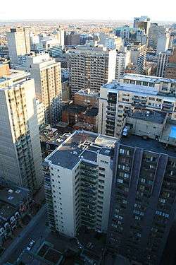
Apartment buildings in the Shaughnessy Village | |
|
Shaughnessy Village Location of Shaughnessy Village in Montreal | |
| Coordinates: 45°29′34″N 73°34′49″W / 45.492814°N 73.58041°WCoordinates: 45°29′34″N 73°34′49″W / 45.492814°N 73.58041°W | |
| Country | Canada |
| Province | Quebec |
| City | Montreal |
| Borough | Ville-Marie |
| Population (2006)[1] | |
| • Total |
13,000 ( |
Shaughnessy Village is a neighbourhood of Montreal, Quebec, Canada, located on the western side of the Ville-Marie borough. It is bounded by Guy Street to the east, Atwater Street to the west, Sherbrooke Street to the north, and René Lévesque Boulevard and the Ville-Marie Expressway to the south.
This neighbourhood is the most densely populated area of Quebec, due to the large number of high-rise apartment towers built in the 1960s and 1970s.[2] The area is characterized by high-density residential housing and small-businesses, typically owned and operated by immigrants living in the neighbourhood, concentrated at its core, with stately Victorian grey-stone row houses and beaux-arts styled apartment blocks at the edges of the neighbourhood. It is a primarily institutional neighbourhood, with a university, junior college, seminary, hospital and architecture museum among many private schools, colleges and technical schools.
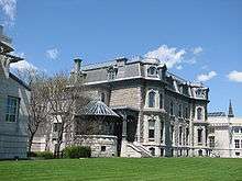
In 1981, local citizens named the neighourhood after Shaughnessy House, built in 1874 for Thomas Shaughnessy, president of the Canadian Pacific Railway.[1] The house was declared a National Historic Site of Canada in 1974, and is now part of the Canadian Centre for Architecture.[3]
Other notable landmarks in the area include the Montreal Forum and Montreal Children's Hospital on Atwater Avenue, Le Faubourg Sainte-Catherine shopping mall and Cabot Square.
History
Prior to Expo '67 and the Olympics, this neighbourhood was considered the gay village (mostly for anglophones).[4]
Demographics
It is thus one of the more cosmopolitan neighbourhoods in the city, as well as being generally more English-speaking than the rest of Montreal. There is a sizeable population of Chinese-Canadians living in the area, so much so that part of the informally named Concordia Ghetto is also sometimes referred to as New Chinatown. Much like Montreal's main Chinatown, it is pan-Asiatic, rather than uniquely Chinese.
The area is home to numerous small independently owned and operated restaurants, bars, bistros and cafés.
Public Transit
The neighbourhood is served by two Montreal Metro Green line stations. Guy-Concordia station in the east and Atwater station to the west. Georges Vanier station on the Orange line is just south of Shaughnessy Village in nearby Little Burgundy. The area is also well-served by numerous bus lines terminating at Atwater Station that connect Westmount, Cote-des-Neiges and much of the rest of the urban core. The Claire-Morissette bike path on De Maisonneuve Boulevard cuts through the centre of the neighbourhood and the area is well served by Bixi stations.
References
- 1 2 Gyulai, Linda (2010-03-13). "Of blight and renewal". The Gazette (Montreal). Retrieved 18 March 2010.
- ↑ Montrealbits.com:Shaughnessy Village
- ↑ "L'Association du Village Shaughnessy Village Association". Retrieved 2008-03-30.
- ↑ Andrea Zanin. "The Village Comes Out: A Quick History". Go-Montreal.com. Retrieved 2008-03-28.
External links
- (French) Shaughnessy Village - City of Montreal
- Shaughnessy Village Association
- Montrealbits.com:Shaughnessy Village
- Shaughnessy Village, A Historical Perspective
 |
Golden Square Mile (Montreal) | | ||
| Westmount, Quebec | |
Quartier Concordia (Montreal), Downtown Montreal | ||
| ||||
| | ||||
| Saint-Henri (Montreal) |