Roosevelt Island


Roosevelt Island is a narrow island in New York City's East River. It lies between Manhattan Island to its west and the borough of Queens on Long Island to its east, and is part of the borough of Manhattan. Running from the equivalent of East 46th to 85th Streets on Manhattan Island, it is about 2 miles (3.2 km) long, with a maximum width of 800 feet (240 m), and a total area of 147 acres (0.59 km2). Together with Mill Rock, Roosevelt Island constitutes Manhattan's Census Tract 238, which has a land area of 0.279 sq mi (0.72 km2),[3] and had a population of 9,520 as of the 2000 United States Census.[4][note 1] It had a population of 11,661 as of the 2010 United States Census.[1]
The island was called Minnehanonck by the Lenape and Varkens Eylandt (Hog Island) by New Netherlanders, and during the colonial era and later as Blackwell's Island. It was known as Welfare Island when it was used principally for hospitals, from 1921 to 1971.[5] It was renamed Roosevelt Island in 1971 after Franklin D. Roosevelt.
Roosevelt Island is owned by the city, but was leased to the state of New York's Urban Development Corporation for 99 years in 1969. Most of the residential buildings on Roosevelt Island are rental buildings. There is also a cooperative (Rivercross) and a condominium building (Riverwalk). One rental building (Eastwood) has left New York State's Mitchell-Lama Housing Program, though current residents are still protected. Three other buildings are now working toward privatization, including the cooperative.
History
In 1637, Dutch Governor Wouter van Twiller purchased the island, then known as Hog Island, from the Canarsie Indians.[6][7] After the English defeated the Dutch in 1666, Captain John Manning seized the island, which became known as Manning's Island, and twenty years later, Manning's son-in-law, Robert Blackwell, became the island's new owner and namesake.[8] In 1796, Blackwell's great-grandson Jacob Blackwell constructed the Blackwell House, which is the island's oldest landmark, New York City's sixth oldest house, and one of the city's few remaining examples of 18th-century architecture.[8]
Through the 19th century, the island housed several hospitals and a prison. In 1828, the City of New York purchased the island for $32,000 (equal to $690,715 in 2014), and four years later, the city erected a penitentiary on the island; the Penitentiary Hospital was built to serve the needs of the prison inmates. By 1839, the New York City Lunatic Asylum opened, including the Octagon Tower, which still stands but as a residential building; it was renovated and reopened in April 2006.[9] The asylum, which was designed by Alexander Jackson Davis, at one point held 1,700 inmates, twice its designed capacity.[8] In 1852, a workhouse was built on the island to hold petty violators in 220 cells. The Smallpox Hospital, designed by James Renwick, Jr., opened in 1856, and two years later, the Asylum burned down and was rebuilt on the same site; Penitentiary Hospital was destroyed in the same fire.[8] In 1861, prisoners completed construction of Renwick's City Hospital (renamed Charity Hospital in 1870), which served both prisoners and New York City's poorer population.[8] In 1872, the Blackwell Island Light, a 50-foot (15 m) Gothic style lighthouse later added to the National Register of Historic Places, was built by convict labor on the island's northern tip under Renwick's supervision. Seventeen years later, in 1889, the Chapel of the Good Shepherd, designed by Frederick Clarke Withers, opened.[8] By 1895, inmates from the Asylum were being transferred to Ward's Island, and patients from the hospital there were transferred to Blackwell's Island. The Asylum was renamed Metropolitan Hospital. However, the last convicts were not moved off the island until 1935, when the penitentiary on Rikers Island opened.[8]
The 20th century was a time of change for the island. The Queensboro Bridge started construction in 1900 and opened in 1909; it passed over the island but did not provide direct vehicular access to it at the time.[8] In 1921, Blackwell's Island was renamed Welfare Island[5] after the City Hospital on the island.[10] In 1930, a vehicular elevator to transport cars and passengers on Queensboro Bridge started to allow vehicular and trolley access to the island.[11][12] In 1939, Goldwater Memorial Hospital, a chronic care facility, opened, with almost a thousand beds in 7 buildings on 9.9 acres (4.0 ha). Thirteen years later, Bird S. Coler Hospital, another chronic care facility, opened, and three years after the Coler Hospital's opening, Metropolitan Hospital moved to Manhattan, leaving the Lunatic Asylum buildings abandoned.[8] The same year, 1955, the Welfare Island Bridge from Queens opened, allowing automobile and truck access to the island and the only non-aquatic means in and out of the island; the vehicular elevator to Queensboro Bridge then closed,[11] but wasn't demolished until 1970.[12] As late as August 1973, though, another passenger elevator ran from the Queens end of the bridge to the island.[13][14]
More changes came in the latter half of the century. In 1968, the Delacorte Fountain, opposite the headquarters of the United Nations, opened.[8] Mayor John V. Lindsay named a committee to make recommendations for the island's development in the same year.[15] A year later, the New York State Urban Development Corporation (UDC) signed a 99-year lease for the island, and architects Philip Johnson and John Burgee created a plan for apartment buildings housing 20,000 residents. In 1971, Welfare Island was renamed Roosevelt Island in honor of Franklin D. Roosevelt, and four years later, planning for his eponymous park, Franklin D. Roosevelt Four Freedoms Park, started.[5] Federal funding for redevelopment came from the New Community Act. In 1976, the Roosevelt Island Tramway opened, connecting the island directly with Manhattan,[16] but it was eight years before the New York State legislature created the Roosevelt Island Operating Corporation (RIOC) to operate the tramway, with a nine-person board of directors appointed by the Governor, two suggested by the Mayor of New York City, and three of whom are residents of the island.[8] The tramway was meant as a temporary solution to the then-lack of subway service to the island, which began in 1989 with the opening of the Roosevelt Island subway station, on what is now the F train.[17]
During the 21st century, the area became more gentrified. In 1998, the Blackwell Island Light was restored by an anonymous donor.[8] In 2006, the restored Octagon Tower opened, serving as the central lobby of a two-wing, 500-unit apartment building.[8] In 2010, the Roosevelt Island Tramway reopened after renovations.[18] A year later, Southpoint Park opened south of Goldwater Memorial Hospital, near the island's southern end,[19] Cornell Tech, a joint venture between Technion – Israel Institute of Technology and Cornell University, was announced the same year.[20][21] In 2012, the Franklin D. Roosevelt Four Freedoms Park was dedicated and opened to the public as a state park.[22] Construction of the new Cornell Tech campus began in January 2014 with the arrival of equipment on Roosevelt Island for the building of a fence around the construction site and for the demolition of the existing Coler-Goldwater Specialty Hospital's south campus; demolition began in March 2014,[23] but city officials say they do not have plans to close the north campus of the hospital.[24] The school plans to begin operations on the island in 2017.[25]

Architecture

Though small, Roosevelt Island has a distinguished architectural history. It has several architecturally significant buildings, and has been the site of numerous important unbuilt architectural competitions and proposals. The island's master plan, adopted by the New York State Urban Development Corporation in 1969, was developed by the firm of Philip Johnson and John Burgee. The plan divided the island into three residential communities, and it forbade the use of automobiles on the island; the plan intended for residents to park their cars in a large garage and use public transportation to get around. Another innovation was the plan's development of a 'mini-school system,' in which classrooms for the island's public intermediate school were distributed among all the residential buildings in a campus-like fashion (as opposed to being centralized in one large building).
The first phase of Roosevelt Island's development was called "Northtown." It consists of four housing complexes: Westview, Island House, Rivercross, and Eastwood (also known as the WIRE buildings). Rivercross is a Mitchell-Lama co-op, while the rest of the buildings in Northtown are rentals. Eastwood, the largest apartment complex on the island, and Westview were designed by noted architect Josep Lluis Sert, then dean of Harvard Graduate School of Design. Eastwood, along with Peabody Terrace (in Cambridge, Massachusetts), is a prime example of Sert's high-rise multiple-dwelling residential buildings. It achieves efficiency by triple-loading corridors with duplex apartment units, such that elevators and public corridors are only needed every three floors. Island House and Rivercross were designed by Johansen & Bhavnani. The two developments were noteworthy for their use of pre-fabricated cladding systems. Subsequent phases of the island's development have been less innovative, architecturally. Northtown Phase II was developed by the Starrett Corporation and designed by the firm, Gruzen Samton, in a pseudo-historical post-modern style. It was completed in 1989, over a decade after Northtown. Southtown (also referred to as Riverwalk by the developers[26]) is the third phase of the island's development. This phase, also designed by Gruzen Samton, was not started until 1998, and is still in the process of development. When complete, Southtown will have 2,000 units in nine buildings.[27]
The Octagon, one of the island’s six landmarks, was restored in April 2006, and the national landmark building is now a high-end apartment community. It also houses the largest array of solar panels on any building in New York City. When The Octagon opened its doors, many young, affluent tenants started to occupy the studios and one-, two-, and three-bedroom units; 100 of the units therein are set aside for middle-income residents.
In 2006, ENYA (Emerging New York Architects) made the island's abandoned southern end the subject of one of its annual competitions. In addition to Louis Kahn's four-acre Franklin D. Roosevelt Four Freedoms Park at that tip, whose public dedication on October 17, 2012 was tangled in litigation,[28][29] the island has also been the site of numerous other architectural speculations. Rem Koolhaas and the Office of Metropolitan Architecture proposed two projects for the Island in his book "Delirious New York": the Welfare Island Hotel and the Roosevelt Island Redevelopment Proposal (both in 1975–76). That proposal was Koolhaas's entry into a competition held for the development of Northtown Phase II. Other entrants included Peter Eisenman, Robert A. M. Stern, and Oswald Mathias Ungers.
As of 2013, six of the Southtown buildings, with a total of 1,200 units, have been completed. Residential development of Southtown has brought new retail businesses to Roosevelt Island, including a Starbucks and a Duane Reade. Roosevelt Island has long had a limited variety of restaurants; however, as a result of Southtown development, four new restaurants – Nonno's Focacceria (January 2008), Fuji East (April 2008), Riverwalk Bar & Grill (2009), and Pier NYC (2012) – appeared on the West Promenade.

Transportation
Although Roosevelt Island is located directly under the Queensboro Bridge, it is not directly accessible from the bridge itself. A trolley used to connect passengers from Queens and Manhattan to a stop in the middle of the bridge, where passengers took an elevator down to the island. The trolley operated from the bridge's opening in 1909 until April 7, 1957.[11] Between 1930 and 1955, the only vehicular access to the island was provided by an elevator system in the Elevator Storehouse that transported cars and commuters between the bridge and the island. The elevator was closed to the public after the construction of the Roosevelt Island Bridge between the island and Astoria in Queens in 1955; the elevator was demolished in 1970, but a similar elevator ran from the Queensboro Bridge to the island as late as 1973.
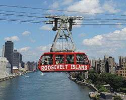
In 1976, the Roosevelt Island Tramway was constructed to provide access to Midtown Manhattan. The tram was closed from March to November 2010, during which all of the components of the tramway, except for the tower bases, were replaced.[30][31]
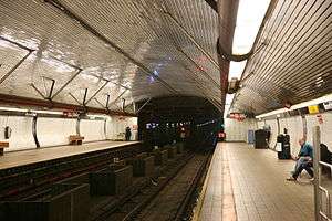
New York City Subway access to the rest of Manhattan and to Long Island City in Queens via the IND 63rd Street Line began in 1989, but access to the rest of Queens did not start until 2001.[note 2] Located more than 100 feet (30 m) below ground level, the Roosevelt Island station (F train) is one of the deepest stations below sea level in the New York City Subway system.
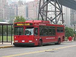
Roosevelt Island's residential community was not designed to support automobile traffic during its planning in the early 1970s. Automobile traffic has become common even though much of the island remains a car-free area. MTA Bus's Q102 route, operating between the island and Queens, obviates the need for automobiles to some extent. However, RIOC operates the Red Bus, a free on-island shuttle bus service, using easily visible bright red buses, that competes directly with the Q102 and connects apartment buildings to the subway and tramway.
Roosevelt Island is expected to be served by the Citywide Ferry Service,[32] starting in 2017.[33][34]
Demographics
2000 U.S. Census
As of the 2000 U.S. Census, Roosevelt Island had a population of 9,520. Fifty-two percent of the population (4,995) were female, and 4,525, or 48%, were male. The population was spread out with 5% under the age of 5, 20% under the age of 18, 67% between the ages of 18 and 65, and 15% over the age of 65.[2]
The racial makeup of the island was 45% white (non-Hispanic), 27% black (non-Hispanic), 14% Hispanics or Latinos of any race, 11% Asian or Pacific Islander, and .3% other races.[2]
The median income was $49,976. 37% had an income under $35,000. 40% had incomes between $35,001 and $99,999, and 23% had an income over $100,000.[2]
55% of the total households were family households, and 45% were non-family households. 17% of the residents were married couples with children, and 19% were married couples without children. 36% of the households were one-person households, and 9% were two or more non-family households. 3% were male-based households with related and unrelated children, and 16% were female-based households with related and unrelated children.[2]
2010 U.S. Census
As of the 2010 U.S. Census, Roosevelt Island had a population of 11,661. 42.7% of the population was born outside the U.S.[1]
The median income was $76,250. 69.3% of households earned more than $50,000. 30.5% earned less than $50,000.[1]
Government and infrastructure
The neighborhood is part of Manhattan Community Board 8. The Roosevelt Island Operating Corporation operates and maintains the island's government and infrastructure. The United States Postal Service operates the Roosevelt Island Station at 694 Main Street.[35] Waste on Roosevelt Island is collected by an automated vacuum collection (AVAC) system using a system of pneumatic tubes; this is the only AVAC system in the United States that serves a residential complex.

Education
Roosevelt Island, as with all parts of New York City, is served by the New York City Department of Education. Residents are zoned to P.S. 217/I.S. 217 Roosevelt Island School, which opened in 1992, combining together schools at various locations on the island.[8] Also, The Child School and Legacy High School serve K–12 special needs children with learning and emotional disabilities.
On December 19, 2011, Mayor Michael Bloomberg announced that Cornell Tech, a Cornell University-Technion-Israel Institute of Technology graduate school of applied sciences, would be built on the island. The $2 billion facility will include 2 million square feet of space on an 11 acre city-owned site, which is currently used for a hospital. Classes will begin off-site in September 2012, with the first classes in the new facility scheduled to start in 2018. The campus will take almost 30 years to be fully complete.[20][21]
The New York Public Library operates the Roosevelt Island Branch at 524 Main Street.[36] The library began in a community room, then moved to its own building in 1979. In 1998, the library became a branch of the NYPL system.[8]
Media
Roosevelt Island has its own community newspaper, The Main Street WIRE, founded in 1979 by Dr. Jack Resnick and published every two weeks (monthly in July and August). However, the WIRE was first published in 1981, following an accident that took the Roosevelt Island Tramway out of service for several months, making travel to and from the island difficult. The incident was scarcely reported by major New York City news sources at the time, so Resnick and several other residents founded the WIRE to report local news. The WIRE derives its name from the first four residential buildings constructed on Roosevelt Island: Westview, Island House, Rivercross, and Eastwood. Current and back issues are available online.[37]
Volunteers deliver the WIRE to every residential door in the community. The newspaper confines its coverage to Roosevelt Island matters, reporting on community concerns ignored by other New York City media, including issues that arise by virtue of Roosevelt Island being a community within New York City which is operated by the State (not the City) of New York, with a local "authority" called the Roosevelt Island Operating Corporation (RIOC) in charge. For several years, The WIRE has editorialized in favor of a stronger element of elected home rule for the community, and various small steps have been taken in that general direction. While Governor David Paterson appointed residents nominated in nominating elections held by the Roosevelt Island Residents Association (RIRA),[38] Governor Andrew Cuomo has not only ignored such elections, but even appointed a non-resident (who later resigned). The newspaper is developed and produced every other week by community volunteers. Editors since its founding have included Dr. Resnick, the late Jim Bowser, and current Editor-Publisher Dick Lutz. Since its founding, The WIRE's focus has always been principally on the Roosevelt Island community. It does not report on national or international news unless there is a direct and special effect on island residents. It is independent of both the Roosevelt Island Operating Corporation (RIOC) and the Roosevelt Island Residents Association (RIRA), though until the RIOC presidency of Charlene Indelicato, a Cuomo appointee, the president of each organization contributed a column. (The RIRA president still does.) Resident letters are an important component of The WIRE's editorial page, providing a forum for residents to comment on the performance of RIOC, which is a New York State agency.[39]
Since the mid-2000s, resident bloggers also provide community support by consolidating various important resources for local news, events, politics, and community issues, including development, transportation, and tourism.[40][41][42][43]
Notable residents and visitors

.jpg)

Prisoners
- George Washington Dixon – served six months for libel against Reverend Francis L. Hawks
- Becky Edelson – for "using threatening language" during a speech[44]
- Emma Goldman – several times, for activities in support of anarchism and birth control and against the World War I draft
- Peter H. Matthews – for operating policy games (illegal lotteries) all over New York City
- Madame Restell – for performing abortions
- Ida Craddock – convicted for obscenity under the Comstock laws
- Boss Tweed – served one year on corruption-related charges
- Mae West – served eight days on public obscenity charges for her play Sex
- Billie Holiday – served on prostitution charges
- Fritz Joubert Duquesne – Nazi spy and leader of the Duquesne Spy Ring, the largest convicted espionage case in United States history
- Dutch Schultz – arrested for burglary
Visitors who described conditions
- Nellie Bly – went undercover as a patient in the Women's Lunatic Asylum and reported what happened in the New York World as well as her book Ten Days in a Mad-House (1887)
- Charles Dickens – described conditions at the "Octagon", an asylum for the mentally ill then located on the northern portion of the island, in his American Notes – 1842
- William Wallace Sanger – oversaw police interviews of 2000 prostitutes at Blackwell's Island and wrote up the findings in The History of Prostitution (1858)
Residents
- Kofi Annan (former resident) – former United Nations Secretary-General[45]
- Michelle Bachelet (former resident) – president of Chile and Executive Director of the United Nations Entity for Gender Equality and the Empowerment of Women (UN Women).[46]
- Jonah Bobo – actor
- Sônia Braga – actress
- Michael Brodsky – author
- Wendy Fitzwilliam (former resident) – former Miss Universe and former Miss Trinidad and Tobago
- Buddy Hackett (former resident; now deceased) – comedian
- Timothy J. Keller – Christian author and minister
- "Grandpa" Al Lewis (former resident, now deceased) – of The Munsters[47][48]
- Sarah Jessica Parker (former resident) – actress
- Andrea Rosen (former resident) – comedian[49]
- Jon Sciambi (former resident) – ESPN broadcaster
- Fez Whatley (former resident) – former co-host of The Ron and Fez Show on Sirius XM satellite radio
In popular culture
Literature
- 1867 – In chapter 13 of Horatio Alger's novel Ragged Dick: Or, Street Life in New York with the Boot Blacks, the character Mickey Maguire, a young tough from Five Points "had acquired an ascendency [sic] among his fellow professionals, and had a gang of subservient followers, whom he led on to acts of ruffianism, not infrequently terminating in a month or two at Blackwell's Island."
- 1893 – In the opening chapter of Stephen Crane's novelette "Maggie: A Girl of the Streets", "a worm of yellow convicts" is seen emerging from a prison building on Roosevelt Island.
- 1904 – In O. Henry's short story "The Cop and the Anthem," the main character, a homeless man named Soapy, schemes to have himself arrested so as to spend the harsh winter serving a three-month sentence in Blackwell's Island prison.
- 1922 – Yank, the main character in Eugene O'Neill's comedy The Hairy Ape, is imprisoned in Blackwell's Island prison, in chapter VI.
- 1925 – Roosevelt Island appears in F. Scott Fitzgerald's classic novel The Great Gatsby as Blackwell's Island, in Chapter Four, when Nick and Jay drive into Manhattan via the Queensboro Bridge.
- 2001 – Roosevelt Island's ruins, particularly the Smallpox Hospital and the Strecker Memorial Laboratory, play a central role in Linda Fairstein's police procedural novel The Dead House (Scribner 2001).
- 2004 – A significant scene in Caitlín R. Kiernan's story "Riding The White Bull" takes place on Roosevelt Island.
- 2005 – In the novel by Caroline B. Cooney, Code Orange, the main character, Mitty, is studying smallpox for his own survival. He goes and visits the Smallpox Hospital ruins on Roosevelt Island.
- 2007 – In the novel by Cassandra Clare, City of Bones, the protagonist is drawn to the island for a showdown with the elusive villain, Valentine.
Film
- 1932 – A Paramount Pictures film entitled No Man of Her Own is released, a light comedy film starring Clark Gable and Carole Lombard. Upon learning that Gable's character is not in South America, but instead learns he has negotiated a deal to serve 90 days and "he's across the river", Lombard's character then looks out of her hotel window to a view across the East River and the Queensboro Bridge, later referring to this as "Blackwell's Island".
- 1939 – A Warner Bros. film entitled Blackwell's Island is released. It stars John Garfield as a crusading reporter investigating corruption in the island's prison.[50]
- 1966 – In the film Mister Buddwing, a sign posted on a bridge in the film reads "Stairway to Welfare Island." Suzanne Pleshette, playing the character Grace, tries to throw herself off the bridge wearing nothing but a fitted trench coat and white ankle boots, before James Garner's character saves her.
- 1981 – A Roosevelt Island Tramway car is held hostage in the Sylvester Stallone film Nighthawks.
- 1983 – The 1983 Italian B movie Escape from the Bronx has a scene filmed at the north end of the island.
- 1985 – In the final scenes of the film Turk 182 the Timothy Hutton character swings above Roosevelt Island on the Queensboro Bridge.
- 1990 – In the first Teenage Mutant Ninja Turtles film, exterior shots of the Renwick Ruins are used as the fictitious location for the Foot Clan's secret hideout.
- 1991 – In the opening scene of City Slickers Billy Crystal's character "Mitch Robbins" is shown commuting to work via the Roosevelt Island tram.
- 1993 – In the film For Love or Money, Doug Ireland (played by Michael J. Fox) wants to buy the "abandoned hotel" at the south end of Roosevelt Island, referring to the ruins of the Smallpox Hospital.
- 1994 – In The Professional Mathilda Lando (played by Natalie Portman) takes the Tramway to Roosevelt Island to seek asylum at what is implied to be the Spencer School, however in the beginning of the film the school's head mistress states on the phone that the school is located in Wildwood, New Jersey.
- 1997 – The film Conspiracy Theory was shot on location in and around New York City. Sites included Times Square, Union Square, Greenwich Village, the Queensboro Bridge, Roosevelt Island, and the Westchester Medical Center in Valhalla, New York.
- 2002 – Near the end of the film Spider-Man, the Green Goblin blows up the Roosevelt Island side tram station and leaves a group of children hanging inside one car. He also brings Spider-Man down to fight with him in the abandoned Smallpox Hospital on the island. The tram and the island make other appearances in Spider-Man media. The island is featured in the video game Spider-Man 2. In The Amazing Spider-Man #161 and #162, appearing on the cover of the latter,[51] and Spider-Man and Hulk fight on Roosevelt Island in The Amazing Spider-Man #328.
- 2002 – In the film Gangs of New York, Leonardo DiCaprio's character Amsterdam Vallon is seen leaving "Hellgate House of Reform, Blackwell's Island, New York City".
- 2003 – In the film Anything Else, Woody Allen's character, David Dobel, is a schoolteacher who lives on the island.
- 2005 – Roosevelt Island is the setting for the film Dark Water by Brazilian director Walter Salles, where Dahlia (Jennifer Connelly) moves into a low-rent apartment with her daughter and then is terrorized by the ghost of a girl that used to live upstairs.
- 2007 – In the film The Brave One, starring Jodie Foster, a memorable scene takes place at the Roosevelt Island parking lot. The film mentions the island several times.
Television
- 1958 – In the "Violent Circle" episode of Naked City (season 1, episode 5), Detective Halloran (James Franciscus) poses as a mental patient in a hospital mental ward on the Island to uncover a murderer.
- 1963 – In the "Carrier" episode of Naked City (season 4, episode 29), a woman (Sandy Dennis) escapes from a chronic care hospital on Welfare Island – as it was then called – to carry a rare disease through New York City.
- 2005 – In the second season episode of CSI: NY called "Dancing with the Fishes", a crime is committed inside the Roosevelt Island tram.
- 2010 – On the TV show 24, NY CTU is based on Roosevelt Island.
- 2010 – The reality TV show America's Next Top Model filmed a photo shoot on the Roosevelt Island tram on April 7.
- 2011 – The television series Unforgettable takes place in part on Roosevelt Island.
- 2012 – The season three finale of White Collar is set largely on Roosevelt Island, including a stunt in which the show's protagonist jumps midair between Tram cars to avoid being captured by the FBI.
- 2015 - The second season of FX's series The Strain has several scenes which take place on Roosevelt Island.
- 2016 - In the third season episode 'P is For Pancake', of TV Land's series Younger, a potential love interest for Hilary Duff's character is rebuffed when he is revealed to be a resident of Roosevelt Island.[52]
Video games
- 1992 – In the final level of the video game Atomic Runner for the Sega Mega Drive/Genesis the level takes place on Roosevelt Island Southpoint Park.
- 2008 – In the video game Grand Theft Auto IV there is an island resembling Roosevelt Island, named Colony Island. It also includes the ruins of a hospital, similar to the Smallpox Hospital. There is also a replica of the tram available for players to ride.
- 2011 – Parts of the video game Crysis 2 take place on Roosevelt Island.
Other
- 1973 – In the original video for Pink Floyd's song "Us and Them," Roosevelt Island appears during a lengthy sequence shot from the Queensboro Bridge.[53]
- 1986 – The King Kong Tramway ride at Universal Studios Hollywood opens, featuring the Roosevelt Island Tram. Another version of the ride would open at Universal Studios Florida in 1990.[54]
- 2006 – The fictional high school which the main characters attend in the GONZO anime series Red Garden is on Roosevelt Island.
- 2009 – On May 23, the island was the site of Improv Everywhere's "MP3 Experiment Six". Approximately 4,500 people traveled to the island to take part in a performance art piece where the southernmost point of the island became a "battleground" for the re-enactment of a fictional melee between townspeople and an ancient wolf.
See also
References
Explanatory notes
- ↑ According to the 2000 U.S. Census, Mill Rock Island (Census Block 9000) is unpopulated.
- ↑ See History of the 63rd Street Line and the articles for the 63rd Street Shuttle, B, F, and Q trains, for more information.
Citations
- 1 2 3 4 Economic, Racial & Religious Diversity on Roosevelt Island
- 1 2 3 4 5 "Community" on the Roosevelt Island Operating Corporation website
- ↑ "FactFinder" United States Census Bureau
- ↑ Hughes, C.J. (September 2, 2007). "An Island Joins the Mainstream". The New York Times. Retrieved May 22, 2010.
- 1 2 3 Pollak, Michael (December 14, 2012). "Name that Island". The New York Times. Retrieved 2012-12-16.
- ↑ Rodriguez-Nava, Gabriel (2003). "The Rise of a Healthy Community". NYC24. Columbia University School of Journalism.
- ↑ Burrows, Edwin G. & Wallace, Mike (1999), Gotham: A History of New York City to 1898, New York: Oxford University Press, ISBN 0-195-11634-8, p. 29
- 1 2 3 4 5 6 7 8 9 10 11 12 13 14 15 "Timeline of Island History". The Main Street Wire.
- ↑ Brockmann, Jorg; Harris, Bill (2002). One Thousand New York Buildings. New York: Black Dog & Leventhal. p. 268. ISBN 978-1-57912-237-9.
- ↑ "Smallpox Hospital (Renwick Ruin)". rihs.us. Roosevelt Island Historical Society. Retrieved 2014-11-16.
- 1 2 3 McCandlish, Phillips (April 7, 1957). "City's Last Trolley at End of Line; Buses Will Replace 49-Year Route on Queensboro Span". The New York Times. p. 1. Retrieved August 17, 2008.
- 1 2 "Transportation". Roosevelt Island Operating Corporation. Retrieved 2010-07-10.
- ↑ Welch, Mary Scott (July 2, 1973). "Walking the City's Bridges". New York. p. 31. Retrieved 2015-03-07.
- ↑ Petroff, John (August 27, 1973). "Bridge Bits" (letter to the editor)". New York. p. 5. Retrieved 2015-03-07.
- ↑ "Welfare Island to be Restudied". The New York Times. February 11, 1968. Retrieved November 24, 2012.
- ↑ Ferretti, Fred (May 18, 1976). "Aerial Tram Ride to Roosevelt Island Is Opened With a Splash on O'Dwyer". The New York Times. p. 69. Retrieved 2010-02-20.
- ↑ Lorch, Donatella (October 29, 1989). "The 'Subway to Nowhere' Now Goes Somewhere". The New York Times. Retrieved November 28, 2012.
- ↑ Grynbaum, Michael M. (November 30, 2010). "Quirky Tram Runs Again, Delighting Its Riders". The New York Times. Retrieved November 28, 2012.
- ↑ Babin, Janet (August 2, 2011). "Park Reopens on Roosevelt Island". WNYC. Retrieved November 23, 2012.
- 1 2 Pérez-Peña, Richard "Cornell Bid Formally Chosen for Science School in City" The New York Times (December 19, 2011)
- 1 2 Brooks, Stan "Mayor Bloomberg: New York City Ready To Declare War On Silicon Valley" "CBS New York" (December 19, 2011)
- ↑ Foderaro, Lisa W> (October 17, 2012). "Dedicating Park to Roosevelt and His View of Freedom". The New York Times. Retrieved November 24, 2012.
- ↑ "Roosevelt Island Campus Project". Retrieved 23 September 2014.
- ↑ "Hospital patients forced out as Roosevelt Island tech campus moves in" by Amy Zimmer (DNAinfo, 3 May 2012)
- ↑ "Innovation. Unbound.". New York City: Cornell Tech.
- ↑ "Riverwalk Crossing Luxury Apartments on NYC's Roosevelt Island". riverwalknyc.com. Retrieved 28 May 2015.
- ↑ "Riverwalk on Roosevelt Island – Hudson, Inc.". hudsoninc.com. Retrieved 28 May 2015.
- ↑ "A Monument to Roosevelt, on the Eve of Dedication, Is Mired in a Dispute With Donors", The New York Times on-line, October 16, 2012
- ↑ "Decades late, FDR memorial park dedicated in NYC", Yahoo! News on-line, October 17, 2012
- ↑ Clark, Roger (November 30, 2010). "Roosevelt Island Tram Once Again Running Over The East River". NY1. Retrieved November 30, 2010.
- ↑ Roosevelt Island Operating Corporation (November 24, 2010). "You are cordially Invited to the Grand Reopening of the Roosevelt Island Aerial Tramway" (PDF). Retrieved November 27, 2010.
- ↑ DNAinfoNewYork. "Proposed Routes for NYC's Expanded Ferry Service". Scribd. Retrieved September 22, 2016.
- ↑ "Citywide Ferry Service to Launch in June 2017, Official Says". DNAinfo New York. 2016-03-03. Retrieved 2016-09-22.
- ↑ "New York City's Ferry Service Set to Launch in 2017". NBC New York. Retrieved 9 May 2016.
- ↑ "Post Office Location – Roosevelt Island." United States Postal Service. Retrieved on January 30, 2009.
- ↑ "Roosevelt Island Branch." New York Public Library. Retrieved on December 22, 2008.
- ↑ "Old NYC 10044". The Main Street WIRE.
- ↑ "RIRA Online". Roosevelt Island Residents Association.
- ↑ The Main Street WIRE official website
- ↑ "Partners: Rossevelt Islander Blog". Waterfront Alliance.
- ↑ Chan, Sewell; Giambusso, David (August 8, 2008). "Variable-Speed Escalators Off to a Shaky Start". The New York Times.
- ↑ Bennett, Chuck (April 18, 2011). "Roosevelt I. statue of disabled FDR". New York Post.
- ↑ "Roosevelt Island 360". Become a New Yorker. March 6, 2011.
- ↑ "Free Becky Edelson; Funeral Plans Off". The New York Times. August 21, 1914.
- ↑ Karmin, Craig (July 23, 2010). "Roosevelt Island Pitch: Better than the 'Burbs". The Wall Street Journal. Retrieved 2011-01-23.
- ↑ Insunza, Andrea; Ortega, Javier (24 October 2013). "Cuánto ha cambiado Bachelet". Qué Pasa (in Spanish). Retrieved 25 October 2013.
- ↑ Homme, Alexander (October 30, 2009). "Roosevelt Island".
Al Lewis was also known as the unofficial mayor of Roosevelt Island
- ↑ Senft, Bret (September 23, 2006). "With Style, a Goodbye to Grampa Al". The Main Street Wire.
- ↑ Eliot Glazer (2007-10-11). "Inside With: Andrea Rosen". The Apiary.
- ↑ Blackwell's Island at the Internet Movie Database
- ↑ Comics:Amazing Spider-Man Vol 1 162, Marvel Database Project.
- ↑ TV Fanatic:'Younger Season 3 Episode 5 Review: P Is For Pancake'
- ↑ Cousido, P., Nueva York Impactante (Buenos Aires: Recorriendo Destinos, 2013), p. 155.
- ↑ "King Kong: The Monster Who Created Universal Studios Florida", Peter Alexander, Totally Fun Company.
External links
| Wikimedia Commons has media related to Roosevelt Island. |
| Wikivoyage has a travel guide for Manhattan/Roosevelt Island. |
RIOC:
- Official website for RIOC, Roosevelt Island Operating Corporation
- Parks & Recreation Roosevelt Island Operating Corporation's website for Events, memberships, permits
- Roosevelt Island Residents Association
Community resources, news, events, issues:
- The Main Street WIRE
- Roosevelt Islander, blog by Rick O'Conor
Other:
- Roosevelt Island 360
- Photo Tour of Roosevelt Island
- 1903 Panorama of Blackwell's Island, Library of Congress, Thomas A Edison motion picture
- The Island Nobody Knows, a fully digitized exhibition catalog about Roosevelt Island from The Metropolitan Museum of Art Libraries