Richwood, New Jersey
| Richwood, New Jersey | |
|---|---|
| Census-designated place | |
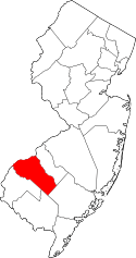
 Richwood, New Jersey  Richwood, New Jersey  Richwood, New Jersey Location of Richwood in Gloucester County. Inset: Location of Gloucester County in New Jersey. | |
| Coordinates: 39°42′58″N 75°10′21″W / 39.715978°N 75.172472°WCoordinates: 39°42′58″N 75°10′21″W / 39.715978°N 75.172472°W | |
| Country |
|
| State |
|
| County | Gloucester |
| Townships | Harrison and Mantua |
| Area[1] | |
| • Total | 8.910 sq mi (23.077 km2) |
| • Land | 8.850 sq mi (22.921 km2) |
| • Water | 0.060 sq mi (0.157 km2) 0.68% |
| Elevation[2] | 138 ft (42 m) |
| Population (2010 Census)[3] | |
| • Total | 3,459 |
| • Density | 390.9/sq mi (150.9/km2) |
| Time zone | Eastern (EST) (UTC-5) |
| • Summer (DST) | Eastern (EDT) (UTC-4) |
| ZIP code | 08074[4] |
| Area code(s) | 856 |
| FIPS code | 3462820[1][5] |
| GNIS feature ID | 02584022[1][6] |
Richwood is an unincorporated community and census-designated place (CDP) located in Gloucester County, New Jersey, United States, that is split between Harrison Township (with 3,400 of the CDP's residents) and Mantua Township (with 59 of the total).[7] As of the 2010 United States Census, the CDP's total population was 3,459.[3][8]
Geography
According to the United States Census Bureau, the CDP had a total area of 8.910 square miles (23.077 km2), including 8.850 square miles (22.921 km2) of land and 0.060 square miles (0.157 km2) of water (0.68%).[1][9]
Demographics
Census 2010
The 2010 United States Census counted 3,459 people, 1,055 households, and 902 families residing in the CDP. The population density was 390.9 per square mile (150.9/km2). The CDP contained 1,101 housing units at an average density of 124.4 per square mile (48.0/km2). The racial makeup of the CDP was 89.65% (3,101) White, 3.76% (130) Black or African American, 0.06% (2) Native American, 4.22% (146) Asian, 0.00% (0) Pacific Islander, 0.55% (19) from other races, and 1.76% (61) from two or more races. Hispanics or Latinos of any race were 2.83% (98) of the population.[3]
Out of a total of 1,055 households, 50.9% had children under the age of 18 living with them, 76.3% were married couples living together, 5.2% had a female householder with no husband present, and 14.5% were non-families. 11.9% of all households were made up of individuals, and 4.5% had someone living alone who was 65 years of age or older. The average household size was 3.27 and the average family size was 3.57.[3]
In the CDP, 32.0% of the population were under the age of 18, 7.9% from 18 to 24, 21.5% from 25 to 44, 30.5% from 45 to 64, and 8.1% who were 65 years of age or older. The median age was 38.5 years. For every 100 females the census counted 98.5 males, but for 100 females at least 18 years old, it was 102.5 males.[3]
Transportation
Exit 50B on Route 55 is about a half mile from the center of Richwood. The exit provides access to Richwood, via U.S. Route 322. Rowan University in nearby Glassboro is about 1¼ miles from Richwood.
See also
References
- 1 2 3 4 Gazetteer of New Jersey Places, United States Census Bureau. Accessed July 21, 2016.
- ↑ U.S. Geological Survey Geographic Names Information System: Richwood Census Designated Place, Geographic Names Information System. Accessed November 10, 2012.
- 1 2 3 4 5 DP-1 - Profile of General Population and Housing Characteristics: 2010 Demographic Profile Data for Richwood CDP, New Jersey, United States Census Bureau. Accessed November 10, 2012.
- ↑ Look Up a ZIP Code for Richwood, NJ, United States Postal Service. Accessed November 10, 2012.
- ↑ American FactFinder, United States Census Bureau. Accessed September 4, 2014.
- ↑ US Board on Geographic Names, United States Geological Survey. Accessed September 4, 2014.
- ↑ New Jersey: 2010 - Population and Housing Unit Counts - 2010 Census of Population and Housing (CPH-2-32), United States Census Bureau, August 2012. Accessed November 10, 2012.
- ↑ Locality Search, State of New Jersey. Accessed April 19, 2015.
- ↑ US Gazetteer files: 2010, 2000, and 1990, United States Census Bureau. Accessed September 4, 2014.