Bridgeport, New Jersey
| Bridgeport, New Jersey | |
|---|---|
| Unincorporated community | |
 Bridgeport  Bridgeport  Bridgeport | |
| Coordinates: 39°48′03″N 75°20′51″W / 39.80083°N 75.34750°WCoordinates: 39°48′03″N 75°20′51″W / 39.80083°N 75.34750°W | |
| Country |
|
| State |
|
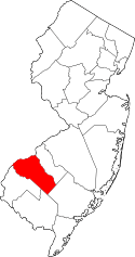
| County | Gloucester |
| Township | Logan |
| Elevation | 8 m (26 ft) |
| Population (2010)[1] | |
| • Total | 504 |
| Time zone | Eastern (EST) (UTC-5) |
| • Summer (DST) | EDT (UTC-4) |
| ZIP code | 08014[2] |
| Area code(s) | 856 |
| GNIS feature ID | 874928[3] |
Bridgeport is an unincorporated community located within Logan Township, in Gloucester County, New Jersey, United States.[4] The area is served as United States Postal Service ZIP Code 08014.[2]
As of the 2010 United States Census, the population for ZIP Code Tabulation Area 08014 was 504.[1]
History
Bridgeport, along with Swedesboro, was one of only two settlements established in New Jersey as a part of the New Sweden colony, the fort at Nya Elfsborg having been abandoned. It was originally called New Stockholm, but the name was changed at a later date.[5] [6]
After the 2001 anthrax attacks, a facility was set up in Bridgeport using a continuous wave accelerator called a Rhodotron from the Belgian company, IBA to irradiate federal mail.[7]
Geography
Bridgeport lies along the Delaware River at the mouth of the Raccoon Creek. US 322 enters New Jersey in Bridgeport via the Commodore Barry Bridge, and continues on to cross US 130 and Interstate 295 before leaving Logan Township. Route 44 is an old alignment of US 130, beginning at a point north of US 322. Unsigned Route 324 is an East-West state highway completely within Bridgeport, running from where a ferry used to take US 322 across the river to a dead end next to the current US 322. There is a private marina and a small airfield in town, and a Penns Grove Secondary line crosses Raccoon Creek at the Conrail Railroad Bridge in Bridgeport at mile 2.0.
References
- 1 2 DP-1 Profile of General Population and Housing Characteristics: 2010 from the 2010 Demographic Profile Data for ZCTA5 08014, United States Census Bureau. Accessed March 16, 2015.
- 1 2 Zip Codes, State of New Jersey. Accessed March 16, 2015.
- ↑ "Bridgeport". Geographic Names Information System. United States Geological Survey.
- ↑ Locality Search, State of New Jersey. Accessed June 9, 2016.
- ↑ The Swedes and Finns in New Jersey (Federal Writers' Project of WPA. Bayonne, New Jersey: Jersey Printing Company, Inc. 1938)
- ↑ "New Sweden". familysearch.org.
- ↑ Postmaster Asks Senate For Bailout Of $5 Billion, The Washington Post, November 9, 2001