Rapid transit
.jpg)
Rapid transit, also known as heavy rail, metro, subway, tube, or underground, is a type of high-capacity public transport generally found in urban areas.[1][2][3] Unlike buses or trams, rapid transit systems are electric railways that operate on an exclusive right-of-way, which cannot be accessed by pedestrians or other vehicles of any sort,[4] and which is often grade separated in tunnels or on elevated railways.
Modern services on rapid transit systems are provided on designated lines between stations typically using electric multiple units on rail tracks, although some systems use guided rubber tyres, magnetic levitation, or monorail. The stations typically have high platforms, without steps inside the trains, requiring custom-made trains in order to avoid gaps. They are typically integrated with other public transport and often operated by the same public transport authorities. However, some rapid transit systems have at-grade intersections between a rapid transit line and a road or between two rapid transit lines.[5] It is unchallenged in its ability to transport large numbers of people quickly over short distances with little use of land. Variations of rapid transit include people movers, small-scale light metro, and the commuter rail hybrid S-Bahn.
The world's first rapid-transit system was the partially underground Metropolitan Railway which opened as a conventional railway in 1863, and now forms part of the London Underground.[6] In 1868, New York opened the elevated West Side and Yonkers Patent Railway, initially a cable-hauled line using static steam engines.
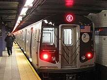
The world's largest single rapid transit service provider by both length of track (842 miles (1,355 km), including non-revenue track)[7] and number of stations (469 stations in total)[8] is the New York City Subway. By length of passenger route, the world's longest single-operator rapid transit system is the Shanghai Metro.[9][10] The busiest rapid transit systems in the world by annual ridership are the Tokyo subway system, the Seoul Metropolitan Subway, the Moscow Metro, the Beijing Subway, and the Shanghai Metro.[11] In terms of length of route per inhabitants, the densest system is Madrid Metro: 294 km of tracks for 6.5 million inhabitants.
Terminology
Metro is the most common term for underground rapid transit systems used by non-native English speakers.[12] Rapid transit systems may be named after the medium by which passengers travel in busy central business districts; the use of tunnels inspires names such as subway,[13] underground,[14] Untergrundbahn (U-Bahn) in German,[15] or the Tunnelbana (T-bana) in Swedish;[16] the use of viaducts inspires names such as elevated (el or L), skytrain,[17] overhead, overground or Hochbahn in German. One of these terms may apply to an entire system, even if a large part of the network (for example, in outer suburbs) runs at ground level.
In most of Britain, a subway is a pedestrian underpass; the terms Underground and Tube are used for the London Underground, and the North East England Tyne and Wear Metro, mostly overground, is known as the Metro. In Scotland, however, the Glasgow Subway underground rapid transit system is known as the Subway. Conversely, in the U.S., underground mass transit systems are primarily known as subways, and the term metro is short for metropolitan area. Two exceptions are Washington, D.C.'s subway system the Washington Metro, Los Angeles Metro Rail, and the Miami Metrorail, which are generally called the Metro.[18]
History
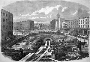
The opening of London's steam-hauled Metropolitan Railway in 1863 marked the beginning of rapid transit. Initial experiences with steam engines, despite ventilation, were unpleasant. Experiments with pneumatic railways failed in their extended adoption by cities. Electric traction was more efficient, faster and cleaner than steam and the natural choice for trains running in tunnels and proved superior for elevated services. In 1890 the City & South London Railway was the first electric-traction rapid transit railway, which was also fully underground.[19] Both railways were eventually merged into London Underground. The 1893 Liverpool Overhead Railway was designed to use electric traction from the outset.[20]
The technology quickly spread to other cities in Europe, the United States, Argentina, and Canada, with some railways being converted from steam and others being designed to be electric from the outset. Budapest in Hungary and Glasgow, Chicago and New York all converted or purpose-designed and built electric rail services.[21] In the 1960s and 70s and many new systems were introduced in Europe, Asia and Latin America.[15]
Advancements in technology have allowed new automated services. Hybrid solutions have also evolved, such as tram-train and premetro, which incorporate some of the features of rapid transit systems.[19] In response to cost, engineering considerations and topological challenges some cities have opted to construct tram systems.[22]
Operation
Rapid transit is used in cities, agglomerations, and metropolitan areas to transport large numbers of people often short distances at high frequency. The extent of the rapid transit system varies greatly between cities, with several transport strategies.
Some systems may extend only to the limits of the inner city, or to its inner ring of suburbs with trains making frequent station stops. The outer suburbs may then be reached by a separate commuter rail network where more widely spaced stations allow higher speeds. In some cases the differences between urban rapid transit and suburban systems are not clear.[3]
Rapid transit systems may be supplemented by other systems such as buses, trams, or commuter rail. This combination of transit modes serves to offset certain limitations of rapid transit such as limited stops and long walking distances between outside access points. Bus or tram feeder systems transport people to rapid transit stops.[23]
Lines
Each rapid transit system consists of one or more lines, or circuits. Each line is serviced by at least one specific route with trains stopping at all or some of the line's stations. Most systems operate several routes, and distinguish them by colors, names, numbering, or a combination thereof. Some lines may share track with each other for a portion of their route or operate solely on their own right-of-way. Often a line running through the city center forks into two or more branches in the suburbs, allowing a higher service frequency in the center. This arrangement is used by many systems, such as the Copenhagen Metro,[24] the Oslo Metro and the New York City Subway.[25]
Alternatively, there may be a single central terminal (often shared with the central railway station), or multiple interchange stations between lines in the city centre, for instance in the Prague Metro.[26] The London Underground[27] and Paris Métro[28] are densely built systems with a matrix of crisscrossing lines throughout the cities. The Chicago 'L' has most of its lines converging on The Loop, the main business, financial, and cultural area. Some systems have a circular line around the city center connecting to radially arranged outward lines, such as the Moscow Metro's Koltsevaya Line and Tokyo's Yamanote Line.
The capacity of a line is obtained by multiplying the car capacity, the train length, and the service frequency. Heavy rapid transit trains might have six to twelve cars, while lighter systems may use four or fewer. Cars have a capacity of 100 to 150 passengers, varying with the seated to standing ratio—more standing gives higher capacity. Bilevel cars have more space, allowing the higher seated capacity needed on longer journeys. The minimum time interval between trains is shorter for rapid transit than for mainline railways owing to the use of block signaling: the minimum headway might be 90 seconds, which might be limited to 120 seconds to allow for recovery from delays. Typical capacity lines allow 1,200 people per train, giving 36,000 people per hour. The highest attained capacity is 80,000 people per hour by the MTR Corporation in Hong Kong.[29]
Network topologies
Rapid transit topologies are determined by a large number of factors, including geographical barriers, existing or expected travel patterns, construction costs, politics, and historical constraints. A transit system is expected to serve an area of land with a set of lines, which consist of shapes summarized as "I", "U", "S", and "O" shapes or loops. Geographical barriers may cause chokepoints where transit lines must converge (for example, to cross a body of water), which are potential congestion sites but also offer an opportunity for transfers between lines. Loops provide good coverage, but are inefficient for everyday commuting use. A rough grid pattern can offer a wide variety of routes while still maintaining reasonable speed and frequency of service.[30]
|


Passenger information
Rapid transit operators have often built up strong brands. The use of a single letter as a station sign has become widespread, with systems identified by the letters L, M, S, T and U, among others.[31]
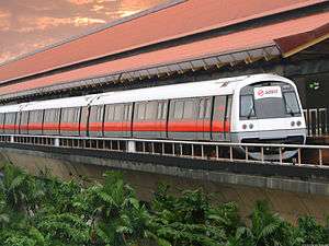
Some systems, like the Singapore MRT, assign two-letter symbols to each line. Accordingly, each station was assigned a unique alphanumeric symbol, for example, CG2 Changi Airport (2nd station on the Changi Airport branch of the East West Line). Interchange stations would have at least two codes. For example, NS26 EW14 Raffles Place has two codes, NS26 , 26th station on the North South Line section and EW14 , 14th station on the East West Line section.
Branding has focused on easy recognition—to allow quick identification even in the vast array of signage found in large cities—combined with the desire to communicate speed, safety, and authority.[32]In many cities, there is a single corporate image for the entire transit authority, but the rapid transit uses its own logo that fits into the profile.
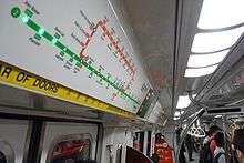
A transit map is a topological map or schematic diagram used to show the routes and stations in a public transport system. The main components are color-coded lines to indicate each line or service, with named icons to indicate stations. Maps may show only rapid transit or also include other modes of public transport.[33]
Transit maps can be found in transit vehicles, on platforms, elsewhere in stations, and in printed timetables. Maps help users understand the interconnections between different parts of the system; for example, they show the interchange stations where passengers can transfer between lines. Unlike conventional maps, transit maps are usually not geographically accurate, but emphasize the topological connections among the different stations. The graphic presentation may use straight lines and fixed angles, and often a fixed minimum distance between stations, to simplify the display of the transit network. Often this has the effect of compressing the distance between stations in the outer area of the system, and expanding distances between those close to the center.[33]
With widespread use of the Internet and cell phones globally, transit operators now use these technologies to present information to their users. In addition to online maps and timetables, some transit operators now offer real-time information which allows passengers to know when the next vehicle will arrive, and expected travel times. The standardized GTFS data format for transit information allows many third-party software developers to produce web and smartphone app programs which give passengers customized updates regarding specific transit lines and stations of interest.
Safety and security

Compared to other modes of transport, rapid transit has a good safety record, with few accidents. Rail transport is subject to strict safety regulations, with requirements for procedure and maintenance to minimize risk. Head-on collisions are rare due to use of double track, and low operating speeds reduce the occurrence and severity of rear-end collisions and derailments. Fire is more of a danger underground, such as the King's Cross fire in London in November 1987, which killed 31 people. Systems are generally built to allow evacuation of trains at many places throughout the system.[34][35]
High platforms (usually over 1 meter / over 3 feet) are a safety risk, as people falling onto the tracks have trouble climbing back. Platform screen doors are used on some systems to eliminate this danger.
Rapid transit facilities are public spaces and may suffer from security problems: petty crimes, such as pickpocketing and baggage theft, and more serious violent crimes. Security measures include video surveillance, security guards, and conductors. In some countries a specialized transit police may be established. These security measures are normally integrated with measures to protect revenue by checking that passengers are not travelling without paying.[36] Rapid transit systems have been subject to terrorism with many casualties, such as the 1995 Tokyo subway sarin gas attack[37] and the 2005 "7/7" terrorist bombings on the London Underground.
Infrastructure

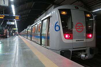
Most rapid transit trains are electric multiple units with lengths from three to over ten cars.[38] Crew sizes have decreased throughout history, with some modern systems now running completely unstaffed trains.[39] Other trains continue to have drivers, even if their only role in normal operation is to open and close the doors of the trains at stations. Power is commonly delivered by a third rail or by overhead wires. The whole London Underground network uses fourth rail and others use the linear motor for propulsion.[40] Most run on conventional steel railway tracks, although some use rubber tires, such as the Montreal Metro and Mexico City Metro and some lines in the Paris Métro. Rubber tires allow steeper gradients and a softer ride, but have higher maintenance costs and are less energy efficient. They also lose traction when weather conditions are wet or icy, preventing above-ground use of the Montréal Metro but not rubber-tired systems in other cities.[41] High capacity Monorails with larger and longer trains can be classified as rapid transit systems. Such monorail systems recently started operating in Chongqing and São Paulo. Light metro is a subclass of rapid transit has the speed and grade separation of a "full metro'' but for smaller passenger numbers. It often has smaller loading gauges, lighter train cars and smaller consists of typically two to four cars. Light metros are typically used as Feeder lines into the main rapid transit system.[42] For instance, the LRT in Singapore serves individual neighbourhoods and complements the MRT.
Some systems have been built from scratch, others are reclaimed from former commuter rail or suburban tramway systems that have been upgraded, and often supplemented with an underground or elevated downtown section.[16] At grade alignments with a dedicated right-of-way. are typically used only outside dense areas, since they create a physical barrier in the urban fabric that hinders the flow of people and vehicles across their path and have a larger physical footprint. This method of construction is the cheapest as long as land values are low. It is often used for new systems in areas that are planned to fill up with buildings after the line is built.[43]
Underground tunnels move traffic away from street level, avoiding delays caused by traffic congestion and leaving more land available for buildings and other uses. In areas of high land prices and dense land use, tunnels may be the only economic route for mass transportation. Cut-and-cover tunnels are constructed by digging up city streets, which are then rebuilt over the tunnel; alternatively, tunnel-boring machines can be used to dig deep-bore tunnels that lie further down in bedrock.[19]
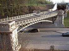
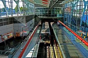
Elevated railways are a cheaper and easier way to build an exclusive right-of-way without digging expensive tunnels or creating barriers. In addition to street level railways they may also be the only other feasible alternative due to considerations such as a high water table close to the city surface that raises the cost of, or even precludes underground railways (e.g. Miami). Elevated guideways were popular around the beginning of the 20th century, but fell out of favor; they came back into fashion in the last quarter of the century—often in combination with driverless systems, for instance Vancouver's SkyTrain, London's Docklands Light Railway,[44] the Miami Metrorail, and the Bangkok Skytrain.[45]
Stations

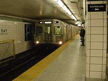
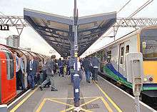
Stations function as hubs to allow passengers to board and disembark from trains. They are also payment checkpoints and allow passengers to transfer between modes of transport, for instance to buses or other trains. Access is provided via either island- or side platforms.[46] Underground stations, especially deep-level ones, increase the overall transport time: long escalator rides to the platforms mean that the stations can become bottlenecks if not adequately built. Some underground stations are integrated into shopping centers, or have underground access to large nearby commercial buildings.[47] In suburbs, there may be a "park and ride" connected to the station.[48]
To allow easy access to the trains, the platform height allows step-free access between platform and train. If the station complies with accessibility standards, it allows both disabled people and those with wheeled baggage easy access to the trains,[49] though if the track is curved there can be a gap between the train and platform. Some stations use platform screen doors to increase safety by preventing people falling onto the tracks, as well as reducing ventilation costs.
The deepest station in the world is Arsenalna station in Kiev, Ukraine.[50]
Particularly in the former Soviet Union and other Eastern European countries, but to an increasing extent elsewhere, the stations were built with splendid decorations such as marble walls, polished granite floors and mosaics—thus exposing the public to art in their everyday life, outside galleries and museums. The systems in Moscow, St. Petersburg, Tashkent and Kiev are widely regarded as some of the most beautiful in the world.[51] Several other cities such as Stockholm, Montreal, Lisbon, Naples and Los Angeles have also focused on art, which may range from decorative wall claddings, to large, flamboyant artistic schemes integrated with station architecture, to displays of ancient artifacts recovered during station construction.[52] It may be possible to profit by attracting more passengers by spending relatively small amounts on grand architecture, art, cleanliness, accessibility, lighting and a feeling of safety.[53]
Modal tradeoffs and interconnections
Since the 1980s, trams have incorporated several features of rapid transit: light rail systems (trams) run on their own rights-of-way, thus avoiding congestion; they remain on the same level as buses and cars. Some light rail systems have elevated or underground sections. Both new and upgraded tram systems allow faster speed and higher capacity, and are a cheap alternative to construction of rapid transit, especially in smaller cities.[22]
A premetro design means that an underground rapid transit system is built in the city centre, but only a light rail or tram system in the suburbs. Conversely, other cities have opted to build a full metro in the suburbs, but run trams in city streets to save the cost of expensive tunnels. In North America, interurbans were constructed as street-running suburban trams, without the grade-separation of rapid transit. Premetros also allow a gradual upgrade of existing tramways to rapid transit, thus spreading the investment costs over time. They are most common in Germany with the name Stadtbahn.[38]
Suburban commuter rail is a heavy rail system that operates at a lower frequency than urban rapid transit, with higher average speeds, often only serving one station in each village and town. Commuter rail systems of some cities (such as German S-Bahns, Chennai rail, Australian cityrails, Danish S-tog etc.) can be seen as the substitute for the city's rapid transit system providing frequent mass transit within city. As opposed to some cities (such as PATH in New York, Dubai Metro, Shanghai Metro, MetroSur of the Madrid Metro, Singapore MRT, Taipei Metro, Kuala Lumpur Rapid Transit etc.) the mainly urban rapid transit systems have lines that fan out to reach the outer suburbs. With some other urban or "near urban" rapid transit systems (Guangfo Metro, Bay Area Rapid Transit, Los Teques Metro and Seoul Subway Line 7, etc.) serving bi- and multi-nucleus agglomerations.
Some cities have opted for two tiers of urban railways: an urban rapid transit system (such as the Paris Métro, Berlin U-Bahn, London Underground, and the Tokyo subway) and a suburban system (such as their counterparts RER, S-Bahn, future Crossrail & London Overground, JR Urban Lines respectively). The suburban systems may have their own purpose built trackage, run at similar "rapid transit-like" frequencies, and commonly operated by the national railway company. In some cities these suburban services run through tunnels in the city centre and have direct transfers to the rapid transit system, on the same or adjoining platforms.[54][55] California's BART and Washington's Metrorail system is an example of a hybrid of the two: in the suburbs the lines function like a commuter rail line, with longer intervals, and longer distance between stations; in in the downtown areas, the stations become closer together and many lines interline with intervals droping to typical rapid transit headways.
Costs, benefits, and impacts
As of May 2012, 184 cities have built rapid transit systems.[56] The capital cost is high, as is the risk of cost overrun and benefit shortfall; public financing is normally required. Rapid transit is sometimes seen as an alternative to an extensive road transport system with many motorways;[57] the rapid transit system allows higher capacity with less land use, less environmental impact, and a lower cost.[58]
Elevated or underground systems in city centers allow the transport of people without occupying expensive land, and permit the city to develop compactly without physical barriers. Motorways often depress nearby residential land values, but proximity to a rapid transit station often triggers commercial and residential growth, with large transit oriented development office and housing blocks being constructed.[57][59] Also, an efficient transit system can decrease the economic welfare loss caused by the increase of population density in a metropolis.[60]
Rapid transit systems have high fixed costs. Most systems are publicly owned, by either local governments, transit authorities or national governments. Capital investments are often partially or completely financed by taxation, rather than by passenger fares, but must often compete with funding for roads. The transit systems may be operated by the owner or by a private company through a public service obligation. The owners of the systems often also own the connecting bus or rail systems, or are members of the local transport association, allowing for free transfers between modes. Almost all transit systems operate at a deficit, requiring fare revenue, advertising and subsidies to cover costs.
The farebox recovery ratio, a ratio of ticket income to operating costs, is often used to assess operational profitability, with some systems including Hong Kong's MTR Corporation,[61] and Taipei[62] achieving recovery ratios of well over 100%. This ignores both heavy capital costs incurred in building the system, which are often subsidized with soft loans[63] and whose servicing is excluded from calculations of profitability, as well as ancillary revenue such as income from real estate portfolios.[61] Some metros, particularly Hong Kong, are partly financed by the sale of land whose value has been increased by the building of the system,[43] a process known as value capture.
See also
References
- Footnotes
- ↑ "Rapid transit". Merriam-Webster. Retrieved 2013-07-31.
- ↑ UITP (2011). "Recommended basic reference for developing a minimum set of standards for voluntary use in the field of urban rail, according to mandate M/486" (PDF). Retrieved 2014-02-16.
- 1 2 "Glossary of Transit Terminology" (PDF). American Public Transportation Association. Retrieved 2013-07-31.
- ↑ "Rapid Transit". Encyclopedia Britannica. Retrieved 2014-11-28.
- ↑ "Chicago". Retrieved 2015-04-24.
- ↑ Transport for London. London Underground: History. ISBN 978-0-904711-30-1. Retrieved 2013-01-02.
- ↑ "Facts & Figures - Subways". www.nycsubway.org. Retrieved 2014-09-21.
- ↑ "Facts - Subway and Bus Ridership". Metropolitan Transportation Authority (MTA). Retrieved 2014-09-21.
- ↑ "Shanghai now the world's longest metro". Railway Gazette International. 4 May 2010. Retrieved 2010-05-04.
- ↑ Smith, Stephen J. (6 January 2014). "New Starts: Shanghai Metro World's Longest, Panama Canal Drama, Japan's Maglev". Next City. Retrieved 2014-09-21.
- ↑ "Metros: Keeping pace with 21st century cities". uitp.org. International Association of Public Transport (French: L’Union internationale des transports publics (UITP)). 2014. Retrieved 2014-09-20.
- ↑ Fjellstrom&Wright, 2002: p.2
- ↑ Executive ed.: Joseph P. Pickert... (2000). The American Heritage Dictionary of the English Language (Fourth ed.). Houghton Mifflin Company. ISBN 0-618-08230-1.
- ↑ "Definition of "Underground"". Chambers Reference Online. Retrieved 2006-11-28.
- 1 2 White, 2002: 63
- 1 2 Ovenden, 2007: 93
- ↑ Ovenden, 2007: 16
- ↑ "DC Metro System Fast Facts". CNN. 2013-11-03. Retrieved 2015-07-20.
- 1 2 3 Ovenden, 2007: 7
- ↑ Bolger, Paul (2004-11-22). "Site Name: Liverpool Overhead Railway & Dingle Station". Subterranea Britannica. Retrieved 2007-09-19.
- ↑ "Subway". Encyclopædia Britannica online. Retrieved 2006-12-02.
- 1 2 Pulling, Niel (2008-05-22). "Light Rail – the Solution to Inner-City Chaos?". Railway Technology. Retrieved 2008-08-18.
- ↑ Cervero, 1998: 13
- ↑ Ovenden, 2007: 84
- ↑ Ovenden, 2007: 32–35
- ↑ Ovenden, 2007: 95
- ↑ Ovenden, 2007: 28–31
- ↑ Ovenden, 2007: 36–39
- ↑ White, 2002: 65–66
- ↑ Walker, Jarret (2012). Human transit : how clearer thinking about public transit can enrich our communities and our lives. Washington: Island Press. ISBN 978-1-59726-972-8.
- ↑ Ström, 1998: 58
- ↑ Ovenden, 2007: 107
- 1 2 Ovenden, 2007: 9
- ↑ Office of Hazardous Materials Safety. "A Comparison of Risk: Accidental Deaths – United States – 1999–2003". U.S. Department of Transportation. Archived from the original on 7 September 2007. Retrieved 2007-09-10.
- ↑ "Office of Rail Regulation". UK. Health & Safety Executive. Retrieved 2007-09-10.
- ↑ Needle et al., 1997: 10–13
- ↑ "El auto de procesamiento por el 11-M". El Mundo (in Spanish). Retrieved 2008-09-08.
- 1 2 White, 2002: 64
- ↑ Railway Technology. "Toulouse Metro, France". Retrieved 2008-08-20.
- ↑ Sato, Yoshihiko; Matsumoto, Akira & Knothe, Klaus (2002). "Review on rail corrugation studies". Wear. 253 (1–2): 130–139. doi:10.1016/S0043-1648(02)00092-3. Retrieved 2008-08-21.
- ↑ Société de transport de Montréal. The Montreal Métro, a source of pride (PDF). p. 6. ISBN 2-921969-08-4. Archived from the original (PDF) on September 30, 2007.
- ↑ White, 2002: 64–65
- 1 2 Kjenstad, 1994: 46
- ↑ "Docklands Light Railway – About DLR". Archived from the original on 27 October 2006. Retrieved 2006-12-04.
- ↑ "Bangkok Mass Transit System Company Limited – BTS SkyTrain". Archived from the original on 2006-11-19. Retrieved 2006-12-04.
- ↑ Uslan et al., 1990: 71
- ↑ Cervero, 1998: 8
- ↑ Cervero, 1998: 226
- ↑ Boorse, Jack W. (1999). "Dual-Mode Traction Power Distribution for Light Rail Transit: A Design Option". Transportation Research Record. 1677: 67–72. doi:10.3141/1677-09.
- ↑ Ming-Tsun Ke; Tsung-Che Cheng & Wen-Por Wang (2002). "Numerical simulation for optimizing the design of subway environmental control system". Building and Environment. 37 (11): 1139–1152. doi:10.1016/S0360-1323(01)00105-6.
- ↑ "Metro Arts and Architecture". Metro Bits. Retrieved 2006-12-04.
- ↑ Storstockholms Lokaltrafik. "Konståkning i världens längsta konstutställning" (in Swedish). Archived from the original on October 13, 2007. Retrieved 2008-08-20.
- ↑ "10 Ways to Enhance Your Community: Unleash the Power of Public Transportation" (PDF). Archived from the original (PDF) on 17 October 2006. Retrieved 2006-12-04.
- ↑ White, 2002: 63–64
- ↑ Cervero, 1998: 21
- ↑ "World Metro Database". Metro Bits. Retrieved 2013-11-17.
- 1 2 Banister and Berechman, 2000: 258
- ↑ Cervero, 1998: 26
- ↑ European Conference of Ministers of Transport, 2003: 187
- ↑ Prud'homme, Rémy. "Public transport congestion costs: The case of the Paris subway". Transport Policy. Elsevier. 21: 101–109. doi:10.1016/j.tranpol.2011.11.002. Retrieved 2012-04-01.
- 1 2 MTR Corporation (2008-08-05). "Announcement of Unaudited Results for the Six Months Ended 30 June 2008" (PDF). Retrieved 2008-08-21.
- ↑ "Taipei Rapid-Transit Corporation '08 Annual Report" (PDF). Taipei Rapid-Transit Corporation. p. 96. Retrieved 2010-07-06.
- ↑ http://cfusrug.org/articles/financing_strat.php
- Bibliography
- Banister, David & Berechman, Joseph (2000). Transport Investment and Economic Development. Routledge. ISBN 0-419-25590-7.
- Bobrick, Benson (1981). Labyrinths of Iron: a[n] History of the World's Subways. New York: Newsweek Books. ISBN 0-88225-299-2.
- Cervero, Robert (1998). The Transit Metropolis. Island Press. ISBN 1-55963-591-6.
- European Conference of Ministers of Transport (2003). Safe & Sustainable Transport. Paris: OECD Publishing. ISBN 92-821-1303-5.
- Fjellstrom, K.; Wright, L. (2002). "Mass Transit Options" (PDF). Sustainable Transport: A Sourcebook for Policy-Makers in Developing Cities. Deutsche Gesellschaft für Technische Zusammenarbeit. Retrieved 2009-07-09.
- Kjenstad, Rune (1994). På skinner i Bymarka (in Norwegian). Oslo: Baneforlaget. ISBN 82-91448-01-9.
- Ovenden, Mark (2007). Transit Maps of the World. London: Penguin. ISBN 978-0-14-311265-5.
- Needle, Jerome A.; Transportation Security Board & Cobb, Renée M. (1997). Improving Transit Security. Transportation Security Board. ISBN 0-309-06013-3.
- Ström, Marianne (1998). Metro Art. ACR Edition. ISBN 2-86770-068-X.
- White, Peter (2002). Public Transport: Its Planning, Management, and Operation. Taylor & Francis. ISBN 0-415-25772-7.
- Uslan, Mark; American Foundation for the Blind; Peck, Alec; Wiener, William & Stern, Arlene (1990). Access to Mass Transit for Blind and Visually Impaired Travelers. American Foundation for the Blind. ISBN 0-89128-166-5.
- Executive ed.: Joseph P. Pickert... (2000). The American Heritage Dictionary of the English Language (Fourth ed.). Houghton Mifflin Company. ISBN 0-618-08230-1.
External links
| Wikimedia Commons has media related to Rapid transit. |
- Subways.net
- UrbanRail.net
- Small, Kenneth A. (2008). "Urban Transportation". In David R. Henderson. Concise Encyclopedia of Economics (2nd ed.). Indianapolis: Library of Economics and Liberty. ISBN 978-0865976658. OCLC 237794267.