Pyrenees
| Pyrenees Mountains | |
|---|---|
|
Spanish: Pirineos French: Pyrénées Catalan: Pirineus Aragonese: Pirineus Occitan: Pirenèus Basque: Pirinioak, Auñamendiak | |
 Central Pyrenees | |
| Highest point | |
| Peak | Aneto |
| Elevation | 3,404 m (11,168 ft) |
| Coordinates | 42°37′56″N 00°39′28″E / 42.63222°N 0.65778°E |
| Dimensions | |
| Length | 491 km (305 mi) |
| Naming | |
| Etymology | Pyrene |
| Geography | |
 Topographic map | |
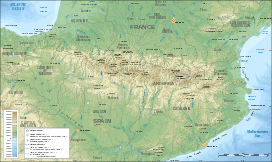
| Countries | France, Spain and Andorra |
| Range coordinates | 42°40′N 1°00′E / 42.67°N 1°ECoordinates: 42°40′N 1°00′E / 42.67°N 1°E |
| Geology | |
| Age of rock | Paleozoic and Mesozoic |
| Type of rock | granite, gneiss, limestone |
The Pyrenees (/ˈpɪrᵻniːz/; Spanish: Pirineos [piɾiˈneos], French: Pyrénées [piʁene], Aragonese: Pirineus, Catalan: Pirineus [piɾiˈnɛus], Occitan: Pirenèus, Basque: Pirinioak [piˈɾinioˌak] or Auñamendiak [auˈɲamendiˌak]) is a range of mountains in southwest Europe that forms a natural border between France and Spain. Peaking at 3,404 metres (11,168 ft) altitude at the peak of Aneto, it separates the Iberian Peninsula from the rest of continental Europe, and extends for about 491 km (305 mi) from the Bay of Biscay (Cap Higuer) to the Mediterranean Sea (Cap de Creus).
For the most part, the main crest forms a massive divider between France and Spain, with the microstate of Andorra sandwiched in between. The Crown of Aragon and the Kingdom of Navarre have historically extended on both sides of the mountain range, with smaller northern portions now in France and larger southern parts now in Spain.[1][2]
The demonym for the noun "Pyrenees" in English is Pyrenean.
Etymology
In classical mythology, Pyrene is a princess who gave her name to the Pyrenees. The Greek historian Herodotus says Pyrene is the name of a town in Celtic Europe.[3] According to Silius Italicus,[4] she was the virginal daughter of Bebryx, a king in Mediterranean Gaul by whom the hero Hercules was given hospitality during his quest to steal the cattle of Geryon[5] during his famous Labors. Hercules, characteristically drunk and lustful, violates the sacred code of hospitality and rapes his host's daughter. Pyrene gives birth to a serpent and runs away to the woods, afraid that her father will be angry. Alone, she pours out her story to the trees, attracting the attention of wild beasts who tear her to pieces.
After his victory over Geryon, Hercules passes through the kingdom of Bebryx again, finding the girl's lacerated remains. As is often the case in stories of this hero, the sober Hercules responds with heartbroken grief and remorse at the actions of his darker self, and lays Pyrene to rest tenderly, demanding that the surrounding geography join in mourning and preserve her name:[6] "struck by Herculean voice, the mountaintops shudder at the ridges; he kept crying out with a sorrowful noise 'Pyrene!' and all the rock-cliffs and wild-beast haunts echo back 'Pyrene!' … The mountains hold on to the wept-over name through the ages." Pliny the Elder connects the story of Hercules and Pyrene to Lusitania, but rejects it as fabulosa, highly fictional.[7]
Geography
Political divisions
The Spanish Pyrenees are part of the following provinces, from east to west: Girona, Barcelona, Lleida (all in Catalonia), Huesca (in Aragon), Navarra (in Navarre) and Gipuzkoa (in the Basque Country).
The French Pyrenees are part of the following départements, from east to west: Pyrénées-Orientales (North Catalonia and Fenolheda), Aude, Ariège, Haute-Garonne, Hautes-Pyrénées, and Pyrénées-Atlantiques (the latter two of which include the Pyrenees National Park).
The independent principality of Andorra is sandwiched in the eastern portion of the mountain range between the Spanish Pyrenees and French Pyrenees.


Physiographical divisions
Physiographically, the Pyrenees may be divided into three sections: the Atlantic (or Western), the Central, and the Eastern Pyrenees. Together, they form a distinct physiographic province of the larger Alpine System division.
In the Western Pyrenees, from the Basque mountains near the Bay of Biscay of the Atlantic Ocean, the average elevation gradually increases from west to east.
The Central Pyrenees extend eastward from the Somport pass to the Aran Valley, and they include the highest summits of this range:
- Pico d'Aneto 3,404 metres (11,168 ft) in the Maladeta ridge,
- Pico Posets 3,375 metres (11,073 ft),
- Monte Perdido 3,355 metres (11,007 ft).
In the Eastern Pyrenees, with the exception of one break at the eastern extremity of the Pyrénées Ariègeoises in the Ariège area, the mean elevation is remarkably uniform until a sudden decline occurs in the easternmost portion of the chain known as the Albères.
Foothills
Most foothills of the Pyrenees are on the Spanish side, where there is a large and complex system of ranges stretching from Spanish Navarre, across northern Aragon and into Catalonia, almost reaching the Mediterranean coast with summits reaching 2,600 m (8,500 ft).[8] At the eastern end on the southern side lies a distinct area known as the Sub-Pyrenees.[9]
On the French side the slopes of the main range descend abruptly and there are no foothills except in the Corbières Massif in the northeastern corner of the mountain system.[10]
Geology
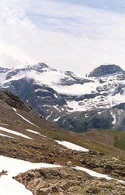
The Pyrenees are older than the Alps: their sediments were first deposited in coastal basins during the Paleozoic and Mesozoic eras. Between 100 and 150 million years ago, during the Lower Cretaceous Period, the Bay of Biscay fanned out, pushing present-day Spain against France and applying intense compressional pressure to large layers of sedimentary rock. The intense pressure and uplifting of the Earth's crust first affected the eastern part and moved progressively to the entire chain, culminating in the Eocene Epoch.
The eastern part of the Pyrenees consists largely of granite and gneissose rocks, while in the western part the granite peaks are flanked by layers of limestone. The massive and unworn character of the chain comes from its abundance of granite, which is particularly resistant to erosion, as well as weak glacial development.
Landscape
Conspicuous features of Pyrenean scenery are:
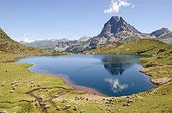
- the absence of great lakes, such as those that fill the lateral valleys of the Alps
- the rarity and great elevation of passes
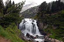
- the large number of the mountain torrents locally called gaves, which often form lofty waterfalls, surpassed in Europe only by those of Scandinavia
- the frequency with which the upper end of a valley assumes the form of a semicircle of precipitous cliffs, called a cirque.
The highest waterfall is Gavarnie (462 m or 1,515 ft), at the head of the Gave de Pau; the Cirque de Gavarnie, in the same valley, together with the nearby Cirque de Troumouse and Cirque d'Estaubé, are notable examples of the cirque formation. Low passes are lacking, and the principal roads and the railroads between France and Spain run only in the lowlands at the western and eastern ends of the Pyrenees, near sea level. Between the two ends of the range, the only passes worth mentioning are the Col de la Perche, between the valley of the Têt and the valley of the Segre, the Port d'Envalira, the highest mountain pass in the Pyrenees and one of the highest points of the European road network, and the Col de Somport or Port de Canfranc, where there were old Roman roads but, apparently, no modern highways.
A notable visual feature of this mountain range is La Brèche de Roland, a gap in the ridge line, which - according to legend - was created by Roland.

Natural resources
The metallic ores of the Pyrenees are not in general of much importance now, though there were iron mines at several locations in Andorra, as well as at Vicdessos in Ariège, and the foot of Canigou in Pyrénées-Orientales long ago. Coal deposits capable of being profitably worked are situated chiefly on the Spanish slopes, but the French side has beds of lignite. The open pit of Trimoun close to the commune of Luzenac (Ariège) is one of the greatest sources of talc in Europe.
Mineral springs are abundant and remarkable, and especially noteworthy are the hot springs, of which the Alps are very deficient. The hot springs, among which those of Les Escaldes in Andorra, Panticosa and Lles in Spain, Ax-les-Thermes, Bagnères-de-Luchon and Eaux-Chaudes in France may be mentioned, are sulphurous and mostly situated high, near the contact of the granite with the stratified rocks. The lower springs, such as those of Bagnères-de-Bigorre (Hautes-Pyrénées), Rennes-les-Bains (Aude) and Campagne-sur-Aude (Aude), are mostly selenitic and not very cold.
Climate
The amount of precipitation the range receives, including rain and snow, is much greater in the western than in the eastern Pyrenees because of the moist air that blows in from the Atlantic Ocean over the Bay of Biscay. After dropping its moisture over the western and central Pyrenees, the air is left dry over the eastern Pyrenees. The winter average temperature is -2 °C (28.4 °F).
Sections of the mountain range vary in more than one respect. There are some glaciers in the western and snowy central Pyrenees, but there are no glaciers in the eastern Pyrenees because there is insufficient snowfall to cause their development. Glaciers are confined to the northern slopes of the central Pyrenees, and do not descend, like those of the Alps, far down into the valleys but rather have their greatest lengths along the direction of the mountain chain. They form, in fact, in a narrow zone near the crest of the highest mountains. Here, as in the other great mountain ranges of central Europe, there is substantial evidence of a much wider expanse of glaciation during the Ice Ages. The best evidence of this is in the valley of Argeles Gazost, between Lourdes and Gavarnie, in the département of Hautes-Pyrénées.
The annual snow-line varies in different parts of the Pyrenees from about 2,700 to 2,800 metres above sea level. In average the seasonal snow is observed at least 50% of the time above 1,600 metres between December and April.[11]
Flora and fauna
Flora
- See main: Flora of the Pyrenees
A still more marked effect of the preponderance of rainfall in the western half of the chain is seen in the vegetation. The lower mountains in the extreme west are wooded, but the extent of forest declines as one moves eastwards. The eastern Pyrenees are peculiarly wild and barren, all the more since it is in this part of the chain that granitic masses prevail. Also moving from west to east, there is a change in the composition of the flora, with the change becoming most evident as one passes the centre of the mountain chain from which point the Corbières stretch north-eastwards towards the central plateau of France. Though the difference in latitude is only about 1°, in the west the flora resembles that of central Europe while in the east it is distinctly Mediterranean in character. The Pyrenees are nearly as rich in endemic species as the Alps, and among the most remarkable instances of that endemism is the occurrence of the monotypic genus Xatardia (family Apiaceae), which grows only on a high alpine pass between the Val d'Eynes and Catalonia. Other examples include Arenaria montana, Bulbocodium vernum, and Ranunculus glacialis. The genus most abundantly represented in the range is that of the saxifrages, several species of which are endemic here.
Fauna
In their fauna the Pyrenees present some striking instances of endemism. The Pyrenean desman is found only in some of the streams of the northern slopes of these mountains; the only other member of this genus is confined to the rivers of the Caucasus in southern Russia. The Pyrenean euprocte (Euproctus pyrenaicus), an endemic relative of the salamander, also lives in streams and lakes located at high altitudes. Among other peculiarities of Pyrenean fauna are blind insects in the caverns of Ariège, the principal genera of which are Anophthalmus and Adelops.
The Pyrenean Ibex mysteriously became extinct in January 2000; the native Pyrenean brown bear was hunted to near-extinction in the 1990s, but it was re-introduced in 1996 when three bears were brought from Slovenia. The bear population has bred successfully, and there are now believed to be about 15 brown bears in the central region around Fos, but only four native ones are still living in the Aspe Valley.
Protected areas
Principal nature reserves and national parks:
- Ordesa y Monte Perdido National Park (Spain)
- Pyrénées National Park (France)
- Aigüestortes i Estany de Sant Maurici National Park (Spain)
- Posets-Maladeta Natural Park (Spain)

Demographics and culture

The Pyrenean region possesses a varied ethnology, folklore and history: see Andorra; Aragon; Ariège; Basque Country; Béarn; Catalonia; Navarre; Roussillon. For their history, see also Almogavars, Marca Hispanica.
The principal languages spoken in the area are Spanish, French, Aragonese, Catalan (in Catalonia and Andorra), and Basque. Also spoken, to a lesser degree, are the Occitan language (the Gascon and Languedocien dialects in France and the Aranese dialect in the Aran Valley).
An important feature of rural life in the Pyrenees is 'transhumance', the moving of livestock from the farms in the valleys up to the higher grounds of the mountains for the summer.[12] In this way the farming communities could keep larger herds than the lowland farms could support on their own. The principal animals moved were cows and sheep, but historically most of the members of farming families also moved to the higher pastures along with their animals, so also took with them pigs, horses[13] and chickens.[12] Transhumance thus took the form of a biannual mass annual migration, moving uphill in May or June[14] and returning to the farms in September or October. During the summer period, the families would live in basic stone cabins[12] in the high mountains. Nowadays, industrialisation and changing agriculture practices have diminished the custom. However, the importance of transhumance continues to be recognised through its celebration in popular festivals.[13][14][15]
Sports and leisure
Both sides of the Pyrenees are popular spots for winter sports such as alpine skiing and mountaineering. The Pyrenees are also a good place for athletes to do high-altitude training in the summertime, such as by bicycling and cross-country running.
In the summer and the autumn, the Pyrenees are usually featured in two of cycling's grand tours, the Tour de France held annually in July and the Vuelta a España held in September. The stages held in the Pyrenees are often crucial legs of both tours, drawing hundreds of thousands of spectators to the region.
Three main long-distance footpaths run the length of the mountain range: the GR 10 across the northern slopes, the GR 11 across the southern slopes, and the HRP which traverses peaks and ridges along a high altitude route. In addition, there are numerous marked and unmarked trails throughout the region.
Pirena is a dog-mushing competition held in the Pyrenees.
Ski resorts

Ski resorts in the Pyrenees include:
- Alp 2500 (Spain)
- Arette (France)
- Astún (Spain)
- Artouste (France)
- Ax-les-Thermes (France)
- Baqueira-Beret (Spain)
- Boí Taüll Resort (Spain)
- Bareges-La Mongie (Tourmalet) (France)
- Luz Ardiden (France)
- Bourg-d'Oueil (France)
- Cauterets (France)
- Candanchú (Spain)
- Cerler (Spain)
- Espot Esquí (Spain)
- Font-Romeu (France)
- Formigal (Spain)
- Gavarnie Gèdre[16] (France)
- Gourette (France)
- Guzet-Neige (France)
- Hautacam (France)
- La Molina (Spain)
- La Pierre Saint Martin
- Le Mourtis (France)
- Les Angles (France)
- Luchon-Superbagnères (France)
- Luz-Ardiden (France)
- Nistos cap nestes (France)
- Panticosa-Los Lagos (Spain)
- Pas de la Casa (Andorra)
- Peyragudes (France)
- Piau-Engaly (France)
- Port Ainé (Spain)
- Port del Comte (Spain)
- Somport (France-Spain)
- Saint Lary (France)
- Soldeu / El Tarter (Andorra)
- Superbagnères (France)
- Tavascan (Spain)
- Vall de Núria (Spain)
- Vallnord (Andorra)
- Vallter 2000 (Spain)
Highest summits
- Aneto (3,404 m)
- Posets (3,375 m)
- Monte Perdido (3,355 m)
- Pic Maudit (3,350 m)
- Cilindro de Marboré (3,328 m)
- Pic de la Maladeta (3,308 m)
- Vignemale (Pique longue) (3,298 m)
- Clot de la Hount (3,289 m)
- Soum de Ramond (3,263 m)
- Pic de Marboré (3,248 m)
- Cerbillona (3,247 m)
- Perdiguero (3,222 m)
- Pic de Montferrat (3,220 m)
- Pic Long (3,192 m)
- Pic Schrader (Grand Batchimale) (3,177 m)
- Campbieil (3,173 m)
- Pic de la cascade oriental (3,161 m)
- Pic Badet (3,160 m)
- Balaïtous (3,144 m)
- Pic du Taillon (3,144 m)
- Pica d'Estats (3,143 m)
- Punta del Sabre (3,136 m)
- Pic de la Munia (3,134 m)
- Pointe de Literole (3,132 m)
- Pic des Gourgs Blancs (3,129 m)
- Pic de Royo (3,121 m)
- Pic des Crabioules (3,116 m)
- Pic de Maupas (3,109 m)
- Pic Lézat (3,107 m)
- Pic de la cascade occidental (3,095 m)
- Pic de Néouvielle (3,091 m)
- Pic de Troumouse (3,085 m)
- Pics d'Enfer (3,082 m)
- Pic de Montcalm (3,077 m)
- Grand pic d' Astazou (3,077 m)
- Épaule du Marboré (3,073 m)
- Pic du port de Sullo (3,072 m)
- Pic des Spijeoles (3,066 m)
- Grand Quayrat (3,060 m)
- Pico Argualas (3,046 m)
- Trois Conseillers (3,039 m)
- Turon de Néouvielle (3,035 m)
- Pic de Batoua (3,034 m)
- Petit Vignemale (3,032 m)
- Pic de Besiberri Sud (3,017 m)
- Pic Ramougn (3,011 m)
- Tour du Marboré (3,009 m)
- Casque du Marboré (3,006 m)
- Grande Fache (3,005 m)
Notable summits below 3,000 metres

- Pic de Palas (2,974 m)
- Pic de Comapedrosa (2,942 m) - highest point of Andorra
- Pic Carlit (2,921 m)
- Puigmal (2,913 m)
- Cotiella (2,912 m)
- Pic de Sanfonts (2,894 m)
- Pic d'Envalira (2,827 m)
- Collarada (2,886 m)
- Pic du Midi d'Ossau (2,885 m)
- Pic du Midi de Bigorre (2,876 m)
- Mont Valier (2,838 m)
- Petit Pic du Midi d'Ossau (2,812 m)
- Pic du Canigou (2,786 m)
- Peña Telera (2,764 m)
- Casamanya (2,740 m)
- Cap de la cometa del forn (2,691 m)[17]
- Visaurin (2,668 m)
- Pic del Port Vell (2,655 m)
- Aspe peak (2,645 m)
- Pic dels Aspres (2,562 m)
- Pedraforca (2,506 m)
- Pic d'Anie (2,504 m)
- Pic de Pedraforca (2,498 m)
- Pic de Madrès (2,469 m)
- Mesa de los Tres Reyes (2,428 m)
- Grande Aiguille d'Ansabère (2,376 m)
- Pic du Soularac (2,368 m)
- Pic du Saint Barthélémy (2,348 m)
- Peña Montañesa (2,291 m)
- Peña Foratata (2,282 m)
- Pic des Trois Seigneurs (2,199 m)
- Pic d'Orhy (2,017 m)
- Chamanchoya (1,935 m)
- Otsogorrigaina (1,922 m)[18]
- Pic de Cagire (1,912 m)
- Pic du Gar (1,785 m)
- Urkulu (1,419 m)
- Larrun (905 m)
See also
- Pre-Pyrenees
- Sub-Pyrenees
- Mountain passes of the Pyrenees
- List of mountains in Aragon
- Montcalm Massif
References
- ↑ Preamble of the "Charter of the Catalan Language"
- ↑ Collins Road Atlas of Europe. London: Harper Collins. 1995. pp. 28–29. ISBN 0-00-448148-8.
- ↑ Herodotus, Histories 2.33.
- ↑ Silius Italicus, Punica 3.415–441.
- ↑ Although Geryon was usually located in the mythical west of the setting sun, he was also associated with Iberia; according to Strabo, his triple-body was preserved at Cadiz in the form of a tree.
- ↑ Ben Tipping, Exemplary Epic: Silius Italicus' Punica (Oxford University Press, 2010), pp. 20–21 online.
- ↑ Pliny the Elder, Natural History 3.3.
- ↑ Pirineus-Prepirineus
- ↑ Jordi Sacasas i Lluís, Geografía de Catalunya, Publicacions L'Abadia de Montserrat. ISBN 978-84-8415-915-5
- ↑ Christophe Neff : Les Corbières maritimes – forment-elles un étage de végétation méditerranéenne thermophile masqué par la pression humaine ? In: Eric Fouache (Edit.): The Mediterranean World Environment and History. IAG Working Group on Geo-archeology, Symposium Proceedings. Environmental Dynamics and History in Mediterranean Areas, Paris, Université de Paris – Sorbonne 24 – 26 avril 2002. Paris, 2003, 191 – 202, (Elsevier France, ISBN 2-84299-452-3).
- ↑ Gascoin, S.; Hagolle, O.; Huc, M.; Jarlan, L.; Dejoux, J.F.; Szczypta, C.; Marti, R.; Sánchez, R. (2015). "A snow cover climatology for the Pyrenees from MODIS snow products". Hydrology and Earth System Sciences (19): 2337–2351. doi:10.5194/hess-19-2337-2015.
- 1 2 3 "The Transhumance". Ariege.com. Retrieved 2016-02-01.
- 1 2 "The traditionnal transhumance of pyrenean horses". Retrieved 2016-02-01.
- 1 2 "Transhumance in the Midi-Pyrenees region of south west France". Retrieved 2016-02-01.
- ↑ "Transhumances dans les Hautes-Pyrénées : un peu de civisme, SVP !" (in French). Retrieved 2016-02-01.
- ↑ Pays Toy Ski Resort
- ↑ 1 of 3 summits
- ↑ "El monte del lobo rojo. Otsogorrigaina (1.922 m). El Correo". El Correo.
Further reading
- Belloc, Hilaire (1909). The Pyrenees. Methuen & Co., London.
- Edelmayer, Friedrich (2012). The Pyrenees Region (in German and English). Institute of European History.
- Paegelow, Claus (2008). Pyrenäen Bibliografie. Andorra, spanische & französische Pyrenäen, Pyrenees Bibliography. Andorra, Spain & French Pyrenees (in German and English). Verlag Claus Paegelow. ISBN 978-3-00-023936-6.
![]() This article incorporates text from a publication now in the public domain: Chisholm, Hugh, ed. (1911). "article name needed". Encyclopædia Britannica (11th ed.). Cambridge University Press.
This article incorporates text from a publication now in the public domain: Chisholm, Hugh, ed. (1911). "article name needed". Encyclopædia Britannica (11th ed.). Cambridge University Press.
- Milne, Tony (2015). 10 Manuels and a Manolete. Handmaid Books, Herblay.
External links
| Wikivoyage has a travel guide for Pyrenees. |
| Wikimedia Commons has media related to Pyrenees. |
- (English) Official website of France's Pyrenees National Park
- (French) Archives of Pyrenees-Atlantiques department
- Great Routes: Pirineos, from a website of the Instituto de Turismo de España
- Les Amis du Livre Pyrénéen (bibliography and history of the Pyrenees)
- Photography Panoramics 360° website
Mountain ranges of France | ||
|---|---|---|
Mountain ranges of Spain | ||
|---|---|---|