Massif Central
| Massif Central | |
|---|---|
|
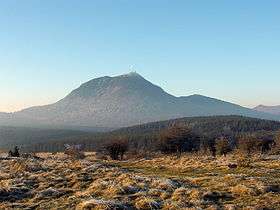
Puy de Dôme is the highest volcano in the chain of volcanoes Chaine des Puys | |
| Highest point | |
| Peak | Puy de Sancy |
| Elevation | 1,886 m (6,188 ft) |
| Coordinates | 45°31′42″N 2°48′51″E / 45.52833°N 2.81417°E |
| Geography | |
 | |
| Country | France |
| States/Provinces | |
| Range coordinates | 46°N 3°E / 46°N 3°ECoordinates: 46°N 3°E / 46°N 3°E |
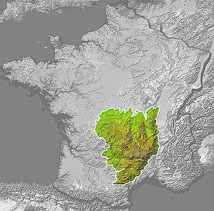
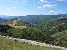
The Massif Central is an elevated region in the middle of southern France, consisting of mountains and plateaus. It covers approximately 15 percent of the country.
Subject to volcanism that has subsided in the last 10,000 years, these central mountains are separated from the Alps by a deep north-south cleft created by the Rhône River and known in French as the sillon rhodanien (literally "the furrow of the Rhône").
The region was a barrier to transportation within France until the opening of the A75 motorway, which not only made North-South travel easier, but also opened up the Massif Central itself.
Geography and geology
The Massif Central is an old massif, formed during the Variscan orogeny, consisting mostly of granitic and metamorphic rocks. It was powerfully raised and made to look geologically younger in the Eastern section by the uplift of the Alps during the Paleogene period and in the Southern section by the uplift of the Pyrenees. The massif thus presents a strongly asymmetrical elevation profile with highlands in the South and in the East (Cévennes) dominating the valley of the Rhône and the plains of Languedoc and by contrast, the less elevated region of Limousin in the northwest.
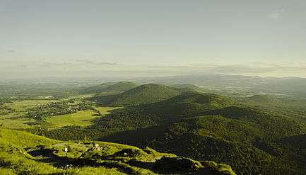
On this crystalline foundation, there are many volcanoes of many different types: volcanic plateaus (Aubrac, Cézallier), stratovolcanoes (Mounts of Cantal, Monts Dore), and small, very recent monogenic volcanoes (Chaîne des Puys, Vivarais). The entire region contains a large concentration of approximately 450 extinct volcanoes. One strip alone, running north to south and less than 60 square miles (160 km2) long, contains 115 of them. The Auvergne Volcanoes National Park is in the massif.
In the South, one remarkable region, made up of features called causses in French, consists of raised calcareous plateaus cut by very deep canyons. The most famous of these is the canyon of Tarn.
Mountains
Mountain ranges, with notable individual mountains, are (roughly north-to-south):

- Chaîne des Puys
- Puy de Dôme (1464 m)
- Puy de Pariou (1210 m)
- Puy de Lassolas (1187 m) and Puy de la Vache (1167 m)
- Monts Dore
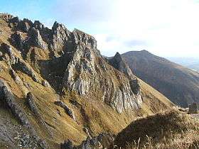
- Puy de Sancy (1886 m)
- Monts du Lyonnais
- Pilat massif
- Crêt de la Perdrix (1,431 m)
- Mounts of Cantal
- Plomb du Cantal (1855 m)
- Puy Mary (1787 m)
- Forez
- Pierre-sur-Haute (1634 m)
- L'Aubrac
- Le Signal de Mailhebiau (1469 m)
- Monts de La Margeride
- Signal de Randon (1551 m)
- Monts du Vivarais (Ardèche)
- Mont Mezenc (1753 m)
- Cévennes
- Mont Lozère (1699 m), the highest non-volcanic summit
- Mont Aigoual (1567 m), near Le Vigan, Florac
- Monts de Lacaune
- Montgrand (1267 m)
- Monts de L'Espinouse
- Sommet de L'Espinouse (1124 m)
- Montagne Noire
- Pic de Nore (1211 m)
Plateaus

- Causse du Larzac
- Plateau de Millevaches
- Plateau de Lévézou
- Causse du Comtal
- Causse de Sauveterre
- Causse de Sévérac
- Causse Méjean
- Causse Noir
- Causse de Blandas
Administration
The following départements are generally considered as part of the Massif Central: Allier, Ardèche, Aude, Aveyron, Cantal, Corrèze, Creuse, Gard, Haute-Loire, Haute-Vienne, Hérault, Loire, Lot, Lozère, Puy-de-Dôme, Rhône and Tarn.
The following régions are part of the Massif Central: Auvergne, Limousin. Part of the following régions are in the Massif Central: Languedoc-Roussillon, Midi-Pyrénées, and Rhône-Alpes.
The largest cities are Clermont-Ferrand and Saint-Étienne.
References
See also
| Wikimedia Commons has media related to Massif Central. |
Mountain ranges of France | ||
|---|---|---|