Porumbeni, Harghita
| Porumbeni Nagygalambfalva | |
|---|---|
| Commune | |
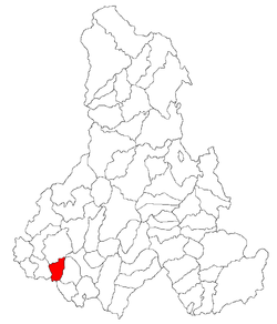 Location of Porumbeni | |
| Coordinates: 46°16′N 25°8′E / 46.267°N 25.133°ECoordinates: 46°16′N 25°8′E / 46.267°N 25.133°E | |
| Country |
|
| County | Harghita County |
| Status | Commune |
| Government | |
| • Mayor | Levente Gyerkó[1] (Democratic Union of Hungarians in Romania) |
| Area | |
| • Total | 40.87 km2 (15.78 sq mi) |
| Population (2011) | |
| • Total | 1,780[2] |
| • Density | 43.55/km2 (112.8/sq mi) |
| Time zone | EET (UTC+2) |
| • Summer (DST) | EEST (UTC+3) |
| Website | Town hall |
Porumbeni (Hungarian: Nagygalambfalva [ˈnɒɟɡɒlɒnpfɒlvɒ]) is a commune in Harghita County, Romania. It lies in the Székely Land, an ethno-cultural region in eastern Transylvania, and is composed of two villages, Porumbenii Mari (the commune center; Nagygalambfalva) and Porumbenii Mici (Kisgalambfalva).
Porumbenii Mari is generally referred to as Galambfalva in Hungarian and was originally called Golumba Mare in Romanian.
Demographics
Formerly part of Mugeni commune, the two villages broke off in 2004. At the 2011 census, 99.33% of inhabitants were Székely Hungarians and 0.51% Roma.
History
The commune has attracted interest from archaeologists, who have uncovered numerous material proofs of human settlement in the area beginning in prehistory. Dacian pottery and ceramic fragments from the Bronze Age, the Age of Migrations, and the Middle Ages have been discovered in sites along the Áj and Nagy brooks. The archaeological record proves a settlement existed during the period of the Árpáds, but the current settlement was documented only in 1332.
The villages belonged first to the Székely seat of Udvarhelyszék, then, from 1876 until 1918, to Udvarhely County in the Kingdom of Hungary. After World War I, by the terms of the Treaty of Trianon of 1920, it became part of Romania. As a result of the Second Vienna Award, it belonged to Hungary again between 1940 and 1944. After World War II, it came under Romanian administration and became part of Romania in 1947. Between 1952 and 1960, it formed part of the Hungarian Autonomous Province, then, of the Mureş-Hungarian Autonomous Province until it was abolished in 1968. Since then, the commune has been part of Harghita County. Its economy is based on agriculture and animal husbandry, with small sectors in milling flour, baking bread, and other commercial activities.
The medieval church, today used by the village's Hungarian Reformed community, first appeared in the papal annals of 1332-1337. An originally Gothic structure with elements from subsequent periods, the church's medieval features were largely destroyed during the reconstruction of the building in the eighteenth and nineteenth centuries.
References
- ↑ (Romanian) alegeri.tv - Alegeri locale 2012 - Rezultate alegeri Primăria Joseni, judeţul Harghita; retrieved on July 12, 2014
- ↑ (Romanian) harghita.insse.ro - Recensământul populaţiei şi al locuinţelor 2011, judeţul Harghita (date ptrovizorii); retrieved on July 12, 2014