Port Amherst, West Virginia
| Port Amherst, West Virginia | |
|---|---|
| Unincorporated community | |
 Port Amherst, West Virginia | |
| Coordinates: 38°18′35″N 81°33′24″W / 38.30972°N 81.55667°WCoordinates: 38°18′35″N 81°33′24″W / 38.30972°N 81.55667°W | |
| Country | United States |
| State | West Virginia |
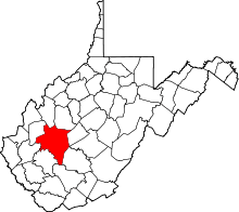
| County | Kanawha |
| Elevation | 607 ft (185 m) |
| Time zone | Eastern (EST) (UTC-5) |
| • Summer (DST) | EDT (UTC-4) |
| Area code(s) | 304 & 681 |
| GNIS feature ID | 1545156[1] |
Port Amherst is an unincorporated community in Kanawha County, West Virginia, United States. Port Amherst is located on the Kanawha River southeast of Charleston. It is the northern terminus of the West Virginia Turnpike and is also served by U.S. Route 60. It was also known as Reed.
References
- ↑ "US Board on Geographic Names". United States Geological Survey. 2007-10-25. Retrieved 2008-01-31.
This article is issued from Wikipedia - version of the 7/30/2014. The text is available under the Creative Commons Attribution/Share Alike but additional terms may apply for the media files.