Pittsburg, Kansas
| Pittsburg, Kansas | |
|---|---|
| City | |
|
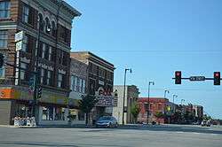
Downtown Pittsburg (2012) | |
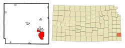 Location within Crawford County and Kansas | |
 KDOT map of Crawford County (legend) | |
| Coordinates: 37°24′37″N 94°41′59″W / 37.41028°N 94.69972°WCoordinates: 37°24′37″N 94°41′59″W / 37.41028°N 94.69972°W | |
| Country | United States |
| State | Kansas |
| County | Crawford |
| Founded | 1876 |
| Incorporated | 1880 |
| Government | |
| • Type | Mayor–Council |
| • Mayor | Chuck Munsell [1][2] |
| • City Manager | Daron Hall |
| Area[3] | |
| • Total | 12.90 sq mi (33.41 km2) |
| • Land | 12.80 sq mi (33.15 km2) |
| • Water | 0.10 sq mi (0.26 km2) |
| Elevation | 942 ft (287 m) |
| Population (2010)[4] | |
| • Total | 20,233 |
| • Estimate (2012[5]) | 20,360 |
| • Density | 1,600/sq mi (610/km2) |
| • µSA | 39,361 |
| Time zone | Central (CST) (UTC-6) |
| • Summer (DST) | CDT (UTC-5) |
| ZIP codes | 66762 |
| Area code(s) | 620 |
| FIPS code | 20-56025 [4] |
| GNIS feature ID | 0469594 [6] |
| Website | pittks.org |
Pittsburg is a city in Crawford County, in southeastern Kansas, United States. It is the most populous city in Crawford County and in southeastern Kansas. As of the 2010 census, the city population was 20,233.[7]
History
On October 23, 1864, a wagon train of refugees had come from Fort Smith, Arkansas, and was escorted by troops from the 6th Kansas Cavalry under the command of Col. William Campbell. These were local men from Cherokee, Crawford, and Bourbon counties. Their enlistment was over, and they were on their way to Fort Leavenworth to be dismissed from service. They ran into the 1st Indian Brigade led by Maj. Andrew Jackson Piercy near the current Pittsburg Waste Water Treatment Plant. They continued to the north when a small group of wagons broke away in an unsuccessful rush to safety. The Confederate troops caught up with them and burned the wagons. The death toll was three Union soldiers and 13 civilian men who had been with the wagon train. It was likely that one of the Confederates had also been killed. A granite marker memorial for the "Cow Creek Skirmish" was placed near the Crawford County Historical Museum on October 30, 2011.[8]
Pittsburg sprang up in the fall of 1876 on a railroad line being built through the neighborhood.[9] It was named after Pittsburgh, Pennsylvania,[10] and maps of the time give the town's name as "New Pittsburgh". George Hobson and Franklin Playter are credited with being the city's founders, establishing a government after its beginnings as a coal mining camp in the 1870s. The city was incorporated in 1879.[11] The “New” was dropped upon incorporation of the City as a third class city on June 21, 1880, with M. M. Snow as its first Mayor. In 1892 it was advanced to a city of the second class, in 1905 Pittsburg attained the rank of first class. During this period, the 'h' was dropped from the official spelling, as the name was pronounced with a "berg" ending, and not a "burra" ending (Scottish). For this reason, the United States Board on Geographic Names altered the city's official name as part of a country-wide standardization effort. Pittsburgh, Pennsylvania similarly lost its 'h' from 1891 to 1911, before winning a rare name reversal following a twenty-year appeal.
The first dwelling was built by J. T. Roach in July 1876.[12] The first post office in Pittsburg was established in August, 1876. The post office's name was spelled as Pittsburgh and New Pittsburgh for some time before 1894.[13] In 1910, the population of Pittsburg was over 14,000.
Pittsburg is in the mineral and oil district and the zinc smelters give employment to 1,200.
Pittsburg is the home to Pittsburg State University, founded in 1903 as a normal training institution. Through the years the College became more diversified in its aims and goals, so that it became a multi-purpose institution. It has always had a strong manual and industrial arts program and has trained many of the area's public and private school teachers.
In 1879, two miners from Joplin began the first commercial attempts at mining in close proximity of Broadway Street. A relic of the city's coal mining days was the Pittsburg & Midway Coal Company, founded in 1885, and one of the oldest continuously running coal companies in the United States (even though its headquarters moved several years ago to Denver, Colorado after the Kansas mines closed). In September 2007, Chevron which owned the company, merged it with its Molycorp Inc. coal mining division to form Chevron Mining, thus ending the Pittsburg corporate name.[14] Midway referred to a coal camp in eastern Crawford County, Kansas that was "midway" between Baxter Springs, Kansas and Fort Scott, Kansas.[15] Kenneth A. Spencer, whose father was among the founders of the company was to play an important role in Kansas and Missouri philanthropy.
Pittsburg was also the most heavily unionized city in Kansas at the beginning of the 20th century.[16] In addition to some coal mining, the economic base of the City now rests on industry.
The city has a rich cultural heritage from many Southern and Eastern European mine workers who settled in and around Pittsburg and Southeastern Kansas. It is situated in a once productive coal field. It now relies heavily on education and government-related employment.
Geography
Pittsburg is located at 37°24′37″N 94°41′59″W / 37.410320°N 94.699816°W.[17] According to the United States Census Bureau, the city has a total area of 12.90 square miles (33.41 km2), of which, 12.80 square miles (33.15 km2) is land and 0.10 square miles (0.26 km2) is water.[3] Pittsburg sits in the Ozark Highlands region, a mix of prairie and forests.
It lies 90 miles (140 km) west of Springfield, Missouri, 124 miles (200 km) south of Kansas City, Missouri, and 137 miles (220 km) northeast of Tulsa, Oklahoma.
Climate
| Climate data for Pittsburg, Kansas | |||||||||||||
|---|---|---|---|---|---|---|---|---|---|---|---|---|---|
| Month | Jan | Feb | Mar | Apr | May | Jun | Jul | Aug | Sep | Oct | Nov | Dec | Year |
| Record high °F (°C) | 73 (23) |
83 (28) |
89 (32) |
97 (36) |
96 (36) |
103 (39) |
110 (43) |
107 (42) |
106 (41) |
94 (34) |
84 (29) |
76 (24) |
110 (43) |
| Average high °F (°C) | 42 (6) |
48 (9) |
58 (14) |
68 (20) |
77 (25) |
85 (29) |
90 (32) |
90 (32) |
81 (27) |
70 (21) |
57 (14) |
44 (7) |
67.5 (19.7) |
| Average low °F (°C) | 23 (−5) |
27 (−3) |
35 (2) |
45 (7) |
56 (13) |
65 (18) |
69 (21) |
68 (20) |
58 (14) |
47 (8) |
36 (2) |
25 (−4) |
46.2 (7.8) |
| Record low °F (°C) | −12 (−24) |
−16 (−27) |
−6 (−21) |
20 (−7) |
32 (0) |
47 (8) |
51 (11) |
48 (9) |
32 (0) |
19 (−7) |
5 (−15) |
−18 (−28) |
−18 (−28) |
| Average precipitation inches (mm) | 1.67 (42.4) |
2.28 (57.9) |
3.65 (92.7) |
4.33 (110) |
6.44 (163.6) |
5.72 (145.3) |
3.96 (100.6) |
3.22 (81.8) |
4.79 (121.7) |
4.16 (105.7) |
3.14 (79.8) |
2.45 (62.2) |
45.81 (1,163.7) |
| Source: weather.com[18] | |||||||||||||
Demographics
| Historical population | |||
|---|---|---|---|
| Census | Pop. | %± | |
| 1880 | 624 | — | |
| 1890 | 6,697 | 973.2% | |
| 1900 | 10,112 | 51.0% | |
| 1910 | 14,755 | 45.9% | |
| 1920 | 18,052 | 22.3% | |
| 1930 | 18,145 | 0.5% | |
| 1940 | 17,571 | −3.2% | |
| 1950 | 19,341 | 10.1% | |
| 1960 | 18,678 | −3.4% | |
| 1970 | 20,171 | 8.0% | |
| 1980 | 18,770 | −6.9% | |
| 1990 | 17,775 | −5.3% | |
| 2000 | 19,243 | 8.3% | |
| 2010 | 20,233 | 5.1% | |
| Est. 2015 | 20,409 | [19] | 0.9% |
| U.S. Decennial Census | |||
2010 census
As of the census[4] of 2010, there were 20,233 people, 8,142 households, and 4,087 families residing in the city. The population density was 1,580.7 inhabitants per square mile (610.3/km2). There were 9,210 housing units at an average density of 719.5 per square mile (277.8/km2). The racial makeup of the city was 87.1% White, 3.3% African American, 0.9% Native American, 2.0% Asian, 0.3% Pacific Islander, 3.0% from other races, and 3.4% from two or more races. Hispanic or Latino of any race were 6.7% of the population.
There were 8,142 households of which 27.1% had children under the age of 18 living with them, 33.3% were married couples living together, 12.2% had a female householder with no husband present, 4.8% had a male householder with no wife present, and 49.8% were non-families. 32.8% of all households were made up of individuals and 10.8% had someone living alone who was 65 years of age or older. The average household size was 2.31 and the average family size was 2.97.
The median age in the city was 26.2 years. 20.7% of residents were under the age of 18; 27% were between the ages of 18 and 24; 23.3% were from 25 to 44; 17.3% were from 45 to 64; and 11.7% were 65 years of age or older. The gender makeup of the city was 49.9% male and 50.1% female.
2000 census
As of the census[4] of 2000, there were 19,243 people, 7,980 households, and 4,213 families residing in the city. The population density was 1,546.2 people per square mile (596.8/km²). There were 8,855 housing units at an average density of 711.5 per square mile (274.6/km²). The people are 89.73% White, 3.11% Black/African American, 1.08% Native American, 1.94% Asian, 0.17% Pacific Islander, 1.90% from other races, and 2.08% from two or more races. Hispanic or Latino of any race were 3.75% of the population.
There were 7,980 households out of which 25.1% had children under the age of 18 living with them, 38.0% were married couples living together, 11.2% had a female householder with no husband present, and 47.2% were non-families. 34.5% of all households were made up of individuals and 12.7% had someone living alone who was 65 years of age or older. The average household size was 2.23 and the average family size was 2.91.
In the city the population was spread out with 20.8% under the age of 18, 24.1% from 18 to 24, 24.1% from 25 to 44, 16.8% from 45 to 64, and 14.1% who were 65 years of age or older. The median age was 28 years. For every 100 females there were 94.1 males. For every 100 females age 18 and over, there were 92.0 males.
The median income for a household in the city was $24,221, and the median income for a family was $36,674. Males had a median income of $26,312 versus $20,132 for females. The per capita income for the city was $15,318. About 13.6% of families and 22.5% of the population were below the poverty line, including 24.2% of those under age 18 and 10.3% of those age 65 or over.
Culture
Events
Little Balkans Days is a celebration that is unique to Pittsburg. This celebration of the community's European ethnic heritage features games, entertainment, a parade, competitions, and arts and crafts. It is held in conjunction with the Labor Day holiday.
Points of interest
- Crawford County Historical Museum
- Miners' Memorial & Immigrant Park
- Pittsburg Aquatic Center
- Kiddieland Amusement Park
Government
The Pittsburg government consists of a mayor and four council members. The council meets the 2nd and 4th Tuesday of each month at 5:30 pm.[1][2]
Education
Primary and secondary education
- Meadowlark Elementary School
- George Nettels Elementary School
- Lakeside Elementary
- Westside Elementary
- Pittsburg Community Middle School
- Pittsburg High School
- St. Mary's-Colgan High School, Parochial Catholic School
- Countryside Christian School, Private Christian School (K-8)
- Covenant Harvest, Christian School
College
- Pittsburg State University
- Fort Scott Community College, School of cosmetology
- Labette Community College, Cherokee Center
Library
- Pittsburg Public Library
- Leonard H. Axe Library, Pittsburg State University offers community library cards.
Media
The Pittsburg Morning Sun is the main newspaper in the city, published six days a week.[20] In addition, Pittsburg State University publishes a weekly student newspaper, the Collegio.[21]
Pittsburg is a center of broadcast media for southeastern Kansas. Two AM and five FM radio stations are licensed to and/or broadcast from the city, and it is the second principal city of the Joplin-Pittsburg television market.[22][23] The market's CBS and Fox network affiliates both broadcast from the city along with an independent station.[24][25][26]
In popular culture and the arts
In late 2012, NBC news anchor Brian Williams, who started his career in Pittsburg, Kansas as a journalist at KOAM-TV, covered the local story of a fried chicken war between Chicken Annie's and Chicken Mary's on the Travel Channel.[27]
Infrastructure
Public transportation
- Bus System, Pittsburg Area Community Transportation (P.A.C.T)
- Taxi services
Airport
- Atkinson Municipal Airport, Aircraft based on the field 41
Medical
- Via Christi Hospital (formerly Mt. Carmel Regional Medical Center) serves the area with services such as Regional Cancer and Heart Centers.
Notable people
Notable individuals who were born in and/or have lived in Pittsburg include actor Roy Glenn,[28] chemical entrepreneur Kenneth A. Spencer,[29] and broadcast journalism pioneer Paul White.[30]
Gallery
 Colonial Fox Theatre
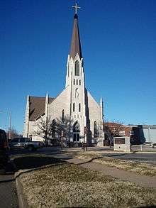 Our Lady of Lourdes Catholic Church
References
- 1 2 Pittsburg - Directory of Public Officials
- 1 2 Pittsburg - Government
- 1 2 "US Gazetteer files 2010". United States Census Bureau. Retrieved 2012-07-06.
- 1 2 3 4 "American FactFinder". United States Census Bureau.
- ↑ "Population Estimates". United States Census Bureau. Retrieved 2013-05-29.
- ↑ "US Board on Geographic Names". United States Geological Survey. 2007-10-25. Retrieved 2008-01-31.
- ↑ "2010 City Population and Housing Occupancy Status". U.S. Census Bureau. Retrieved March 6, 2011.
- ↑ Engraved memorial marker dedicated to lives lost in Cow Creek Skirmish; The Morning Sun; November 1, 2011.
- ↑ A Twentieth Century History and Biographical Record of Crawford County, Kansas. The Lewis Publishing Company. 1905. p. 34.
- ↑ Kansas State Historical Society (1916). Biennial Report of the Board of Directors of the Kansas State Historical Society. Kansas State Printing Plant. p. 171.
- ↑ Blackmar, Frank Wilson (1912). Kansas: A Cyclopedia of State History, Volume 2. Standard Publishing Company. p. 480.
- ↑ History of Pittsburg, Official Homepage of the city
- ↑ "Kansas Post Offices, 1828-1961, page 2 (archived)". Kansas Historical Society. Archived from the original on October 9, 2013. Retrieved 6 June 2014.
- ↑ Chevron executive bullish on growth of coal industry – Denver Business Journal – November 16, 2007
- ↑ Former Mining Communities of the Cherokee-Crawford Coal Field of Southeastern Kansas – Kansas Historical Quarterly – Summer 1972
- ↑ Randy Roberts, Janette Mauk: Pittsburgh, Introduction, p. 9., 2009, ISBN 9780738561165
- ↑ "US Gazetteer files: 2010, 2000, and 1990". United States Census Bureau. 2011-02-12. Retrieved 2011-04-23.
- ↑ "Monthly Averages for Pittsburg, Kansas". Weather.com. The Weather Channel. Retrieved August 15, 2013.
- ↑ "Annual Estimates of the Resident Population for Incorporated Places: April 1, 2010 to July 1, 2015". Retrieved July 2, 2016.
- ↑ "Record Details - Pittsburg Morning Sun". Kansas Press Association. Retrieved 2013-08-15.
- ↑ "PSU Collegio". Mondo Times. Retrieved 2011-12-17.
- ↑ "Radio Stations in Pittsburg, Kansas". Radio-Locator. Retrieved 2011-12-17.
- ↑ "Joplin-Pittsburg TV Market". EchoStar Knowledge Base. Retrieved 2011-12-17.
- ↑ "Stations for Joplin, Missouri". RabbitEars.Info. Retrieved 2011-12-17.
- ↑ "TVQ TV Database Query". Federal Communications Commission. Retrieved 2011-12-17.
- ↑ "AMGTV Affiliates" (PDF). AMGTV. Retrieved 2011-12-17.
- ↑ Brian Williams covers Fried Chicken feud
- ↑ "Roy Glenn". IMDb. Retrieved 2016-04-04.
- ↑ "Kenneth & Helen Spencer of Kansas". Pittsburg State University. Retrieved 2016-04-04.
- ↑ Moore, Barbara (2013-05-13). Sterling, Christopher H., ed. Biographical Encyclopedia of American Radio. Abingdon-on-Thames: Routledge. p. 406.
Further reading
- History of the State of Kansas; William G. Cutler; A.T. Andreas Publisher; 1883. (Online HTML eBook)
- Kansas : A Cyclopedia of State History, Embracing Events, Institutions, Industries, Counties, Cities, Towns, Prominent Persons, Etc; 3 Volumes; Frank W. Blackmar; Standard Publishing Co; 944 / 955 / 824 pages; 1912. (Volume1 - Download 54MB PDF eBook),(Volume2 - Download 53MB PDF eBook), (Volume3 - Download 33MB PDF eBook)
External links
| Wikimedia Commons has media related to Pittsburg, Kansas. |
| Wikisource has the text of a 1911 Encyclopædia Britannica article about Pittsburg, Kansas. |
- City
- Schools
- USD 250, local school district
- Historical
-
 "Pittsburg". Collier's New Encyclopedia. 1921.
 - "Pittsburg, Kans.". The New Student's Reference Work. 1914.
- Maps
- Pittsburg City Map, KDOT
Municipalities and communities of Crawford County, Kansas, United States | ||
|---|---|---|
| Cities | 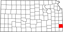 | |
| Townships | ||
| CDPs | ||
| Unincorporated communities | ||
| Footnotes | ‡This populated place also has portions in an adjacent county or counties | |
