Pepperwood, California
Coordinates: 40°26′45″N 123°59′34″W / 40.44583°N 123.99278°W
| Pepperwood | |
|---|---|
| Unincorporated community | |
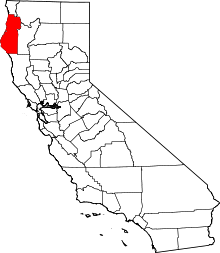
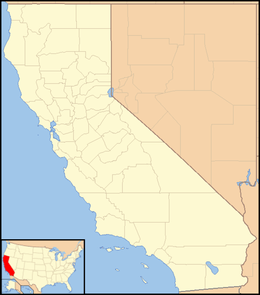 Pepperwood  Pepperwood Location in California | |
| Coordinates: 40°26′45″N 123°59′34″W / 40.44583°N 123.99278°W | |
| Country | United States |
| State | California |
| County | Humboldt County |
| Elevation[1] | 115 ft (35 m) |
Pepperwood (formerly Barkdull)[2] is an unincorporated community in Humboldt County, California.[1] It is located 3.5 miles (5.6 km) northwest of Redcrest,[2] at an elevation of 115 feet (35 m).[1] Pepperwood is the northernmost community along the Avenue of the Giants. The ZIP Code is 95569. The community is inside area code 707.
A post office operated at Pepperwood from 1887 to 1892 and from 1901 to 1965.[2]
Politics
In the state legislature, Pepperwood is in the 2nd Senate District, represented by Democrat Mike McGuire,[3] and the 2nd Assembly District, represented by Democrat Jim Wood.[4]
Federally, Pepperwood is in California's 2nd congressional district, represented by Democrat Jared Huffman.[5]
See also
-
 California portal
References
- 1 2 3 U.S. Geological Survey Geographic Names Information System: Pepperwood, California
- 1 2 3 Durham, David L. (1998). California's Geographic Names: A Gazetteer of Historic and Modern Names of the State. Clovis, Calif.: Word Dancer Press. p. 120. ISBN 1-884995-14-4.
- ↑ "Senators". State of California. Retrieved April 7, 2013.
- ↑ "Members Assembly". State of California. Retrieved April 7, 2013.
- ↑ "California's 2nd Congressional District - Representatives & District Map". Civic Impulse, LLC. Retrieved March 1, 2013.