North Fork Eel River
| North Fork Eel River | |
| River | |
| Country | United States |
|---|---|
| State | California |
| Regions | Trinity County, Mendocino County |
| Part of | Eel River |
| Tributaries | |
| - left | Red Mountain Creek, Hulls Creek |
| - right | Wilson Creek |
| Source | Confluence of East and West Forks |
| - location | Six Rivers National Forest, Trinity County |
| - elevation | 2,123 ft (647 m) |
| - coordinates | 40°12′49″N 123°23′14″W / 40.21361°N 123.38722°W [1] |
| Mouth | Eel River |
| - location | About 6 miles (9.7 km) north of Spyrock, Mendocino County |
| - elevation | 574 ft (175 m) [1] |
| - coordinates | 39°57′24″N 123°26′14″W / 39.95667°N 123.43722°WCoordinates: 39°57′24″N 123°26′14″W / 39.95667°N 123.43722°W [1] |
| Length | 35.5 mi (57 km) [2] |
| Basin | 286 sq mi (741 km2) [2] |
| Discharge | for Mina, CA |
| - average | 644 cu ft/s (18 m3/s) |
| - max | 133,000 cu ft/s (3,766 m3/s) |
| - min | 0.13 cu ft/s (0 m3/s) |
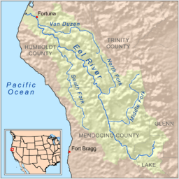 Map of the Eel River drainage basin, including the North Fork Eel River | |
The North Fork Eel River is the smallest of four major tributaries of the Eel River in northwestern California in the United States. It drains a rugged wilderness area of about 286 square miles (740 km2) [2] in the California Coast Ranges, and flows through national forests for much of its length. Very few people inhabit the relatively pristine watershed of the river; there are no operational stream gauges and only one bridge (Mina Road) that crosses the river, near the boundary between Trinity and Mendocino Counties.[3]
Course
It is formed in southern Trinity County deep within the Six Rivers National Forest by the confluence of its East and West Forks. The East Fork, the larger of the two, is sometimes considered the main stem.[1] The river flows south-southeast through the North Fork Wilderness of the national forest, receiving Red Mountain and Hulls Creeks, both from the left. After the Hulls Creek confluence it turns west then south through a gorge into Mendocino County. A few miles after crossing the county line, the river again swings west and flows into the Eel River about 6 miles (9.7 km) north of Spyrock.[4]
Watershed
Primary human usage of the basin include very limited farming, ranching, grazing and logging. A study conducted in 1996 reported that the North Fork Eel River basin has only 200 full-time residents. About 50 percent of the land is government-owned, 48% are private, and 2% belongs to the Round Valley Indian Reservation.[5] Recreational uses, such as hunting and boating, are more common. For rafting, the North Fork Eel River is considered a very "difficult" river, shallow and fluctuating highly in flow, with Class IV and III rapids decreasing in size closer to the mouth.[6][7]
Ecology
The river historically was abundant with steelhead trout, and supported two distinct runs, one in the winter and one in the spring. The total historic population was estimated at 6,930 fish. Coho salmon might also have been present. However, logging and resultant severe erosion caused by the storms in 1964 caused hillsides to slump into the river near the mouth, filling its channel with debris and large boulders. The heavy flows also created several waterfalls that pose barriers to migrating fish, and the average temperature of the river was raised, reducing habitat quality.[2]
See also
References
- 1 2 3 4 "North Fork Eel River". Geographic Names Information System. United States Geological Survey. 1981-01-19. Retrieved 2010-06-18.
- 1 2 3 4 "Steelhead/rainbow trout resources of the North Fork Eel River" (PDF). Center for Ecosystem Management and Restoration. Retrieved 2010-06-18.
- ↑ Graziani, Virginia (2010-05-27). "Eel River tour highlights support for Potter Valley diversion – Humboldt supes call for Eel/Russian Commission meeting". Redwood Times. Retrieved 2010-06-18.
- ↑ USGS Topo Maps for United States (Map). Cartography by United States Geological Survey. ACME Mapper. Retrieved 2010-06-18.
- ↑ "North Fork Eel River Total Maximum Daily Loads for Sediment and Temperature" (PDF). U.S. Environmental Protection Agency. California State Water Resources Control Board. 2002-12-30. Retrieved 2010-06-18.
- ↑ "Salt Creek to Hulls Creek section". California whitewater – Eel River – North Fork, Coast Ranges, Trinity/Mendocino County. Riverfacts. Retrieved 2010-06-18.
- ↑ "Hulls Creek to Mina Road section". California whitewater – Eel River – North Fork, Coast Ranges, Trinity/Mendocino County. Riverfacts. Retrieved 2010-06-18.