Paisley, South Australia
| Paisley South Australia | |||||||||||||
|---|---|---|---|---|---|---|---|---|---|---|---|---|---|
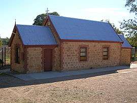 Advent Lutheran Church, Blanchetown | |||||||||||||
 Paisley | |||||||||||||
| Coordinates | 34°24′S 139°40′E / 34.4°S 139.67°ECoordinates: 34°24′S 139°40′E / 34.4°S 139.67°E | ||||||||||||
| Gazetted | September 2000 | ||||||||||||
| Postcode(s) | 5357[1] | ||||||||||||
| Location | 40 km (25 mi) SW of Waikerie | ||||||||||||
| LGA(s) | District Council of Loxton Waikerie | ||||||||||||
| State electorate(s) | Chaffey | ||||||||||||
| Federal Division(s) | Barker | ||||||||||||
| |||||||||||||
Paisley is a locality in the Murray Mallee region of South Australia, across the Murray River from Blanchetown, South Australia.[1] It was formally named in September 2000 for the Hundred of Paisley which contains it. The Hundred of Paisley was named by Governor MacDonnell in 1861 for his private secretary, J. G. Paisley.[2]
The Sturt Highway crosses the northwestern corner of Paisley at the eastern end of the Blanchetown Bridge over the Murray River. The Advent Lutheran Church Blanchetown is actually in Paisley, a few hundred metres north of the eastern end of the bridge.
References
- 1 2 "Placename Details: Paisley". Property Location Browser. Government of South Australia. 31 July 2008. SA0050164. Retrieved 25 April 2016.
- ↑ "Placename Details: Hundred of Paisley". Property Location Browser. Government of South Australia. 29 January 2009. SA0052975. Retrieved 25 April 2016.
This article is issued from Wikipedia - version of the 4/26/2016. The text is available under the Creative Commons Attribution/Share Alike but additional terms may apply for the media files.