Outline of South Dakota
See also: Index of South Dakota-related articles
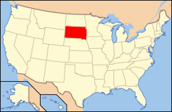
The location of the State of South Dakota in the United States of America
The following outline is provided as an overview of and topical guide to South Dakota:
South Dakota – state located in the Midwestern region of the United States. It is named after the Lakota and Dakota Sioux American Indian tribes. South Dakota is the 17th most extensive, but the 5th least populous and the 5th least densely populated of the 50 United States. Once the southern portion of the Dakota Territory, South Dakota became a state on November 2, 1889 simultaneously with North Dakota. Pierre is the state capital and Sioux Falls, with a population of 159,000, is South Dakota's largest city.
General reference

An enlargeable map of the State of South Dakota
- Names
- Common name: South Dakota
- Pronunciation:
 i/ˌsaʊθ dəˈkoʊtə/
- Pronunciation:
- Official name: State of South Dakota
- Abbreviations and name codes
- Nicknames
- Common name: South Dakota
- Adjectivals: South Dakota, South Dakotan
- Demonym: South Dakotan
Geography of South Dakota
Main article: Geography of South Dakota
- South Dakota is: a U.S. state, a federal state of the United States of America
- Location
- Population of South Dakota: 814,180 (2010 U.S. Census[2])
- Area of South Dakota:
- Atlas of South Dakota
Places in South Dakota
- Historic places in South Dakota
- National Natural Landmarks in South Dakota
- National parks in South Dakota
- State parks in South Dakota
Environment of South Dakota
- Climate of South Dakota
- Superfund sites in South Dakota
- Wildlife of South Dakota
- Fauna of South Dakota
Natural geographic features of South Dakota
Regions of South Dakota
Administrative divisions of South Dakota

An enlargeable map of the 66 counties of the State of South Dakota
- The 66 Counties of the State of South Dakota
- Municipalities in South Dakota
- Cities in South Dakota
- State capital of South Dakota: Pierre
- Largest city in South Dakota: Sioux Falls
- City nicknames in South Dakota
- Towns in South Dakota
- Cities in South Dakota
- Municipalities in South Dakota
Demography of South Dakota
Main article: Demographics of South Dakota
Government and politics of South Dakota
- Form of government: U.S. state government
- United States congressional delegations from South Dakota
- South Dakota State Capitol
- Elections in South Dakota
- United States House of Representatives election in South Dakota, 2002
- United States House of Representatives election in South Dakota, 2004
- United States House of Representatives election in South Dakota, 2006
- United States House of Representatives election in South Dakota, 2008
- United States House of Representatives election in South Dakota, 2010
- United States House of Representatives election in South Dakota, 2012
- United States Senate election in South Dakota, 1980
- United States Senate election in South Dakota, 1986
- United States Senate election in South Dakota, 1992
- United States Senate election in South Dakota, 1996
- United States Senate election in South Dakota, 1998
- United States Senate election in South Dakota, 2002
- United States Senate election in South Dakota, 2004
- United States Senate election in South Dakota, 2008
- United States Senate election in South Dakota, 2010
- United States presidential election in South Dakota, 1972
- United States presidential election in South Dakota, 2000
- United States presidential election in South Dakota, 2004
- United States presidential election in South Dakota, 2008
- Political party strength in South Dakota
Branches of the government of South Dakota
Main article: Government of South Dakota
Executive branch of the government of South Dakota
- Governor of South Dakota
- State departments
Legislative branch of the government of South Dakota
Judicial branch of the government of South Dakota
Law and order in South Dakota
Law of South Dakota
- Cannabis in South Dakota
- Capital punishment in South Dakota
- Constitution of South Dakota
- Crime in South Dakota
- Gun laws in South Dakota
- Law enforcement in South Dakota
Military in South Dakota
History of South Dakota
History of South Dakota, by period
- Prehistory of South Dakota
- Indigenous peoples
- English territory of Rupert's Land, 1670–1707
- French colony of Louisiane, 1699–1764
- British territory of Rupert's Land, (1707–1818)-1870
- Spanish (though predominantly Francophone) district of Alta Luisiana, 1764–1803
- Third Treaty of San Ildefonso of 1800
- French district of Haute-Louisiane, 1803
- Louisiana Purchase of 1803
- Unorganized U.S. territory created by the Louisiana Purchase, 1803–1804
- Lewis and Clark Expedition, 1804–1806
- District of Louisiana, 1804–1805
- Territory of Louisiana, 1805–1812
- Territory of Missouri, 1812–1821
- Unorganized Territory, 1821–1854
- Mexican–American War, April 25, 1846 – February 2, 1848
- Treaty of Fort Laramie of 1851
- Territory of Michigan east of Missouri River, 1805–(1834–1836)–1837
- Territory of Wisconsin east of Missouri River, (1836–1838)–1848
- Territory of Iowa east of Missouri River, 1838–1846
- Territory of Minnesota east of Missouri River, 1849–1858
- Territory of Nebraska west of Missouri River, (1854–1861)–1867
- Territory of Dakota, 1861–1889
- American Civil War, April 12, 1861 – May 13, 1865
- Red Cloud's War, 1866–1868
- Black Hills War, 1876–1877
- State of South Dakota becomes 40th State admitted to the United States of America on November 2, 1889
- Pine Ridge Campaign, 1890–1891
- Wounded Knee Massacre, 1890
- Spanish–American War, April 25 – August 12, 1898
- Wind Cave National Park established on January 9, 1903
- Wounded Knee Incident, February 27 – May 8, 1973
- Badlands National Park established on November 10, 1978
- Pine Ridge Campaign, 1890–1891
History of South Dakota, by region
Municipalities
- History of Beresford, South Dakota
- History of Brookings, South Dakota
- History of Rapid City, South Dakota
- History of Sioux Falls, South Dakota
- History of Yankton, South Dakota
History of South Dakota, by subject
Culture of South Dakota
- Gambling in South Dakota
- Libraries in South Dakota
- Museums in South Dakota
- Religion in South Dakota
- Scouting in South Dakota
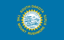
- State symbols of South Dakota
The Arts in South Dakota
Sports in South Dakota
Main article: Sports in South Dakota
Economy and infrastructure of South Dakota
Main article: Economy of South Dakota
- Communications in South Dakota
- Energy in South Dakota
- Health care in South Dakota
- Transportation in South Dakota
- Airports in South Dakota
- Rail transport in South Dakota
- Roads in South Dakota
- Vehicle registration plates of South Dakota
Education in South Dakota
Main article: Education in South Dakota
- Schools in South Dakota
See also
- Topic overview:
- All pages beginning with "South Dakota"
- All pages with titles containing South Dakota
References
- 1 2 3 4 5 South Dakota Symbols, State Names, SHG Resources website, accessed July 7, 2008
- ↑ "U.S. Census Bureau State & County QuickFacts South Dakota".
External links
![]() Wikimedia Atlas of South Dakota
Wikimedia Atlas of South Dakota
This article is issued from Wikipedia - version of the 11/11/2016. The text is available under the Creative Commons Attribution/Share Alike but additional terms may apply for the media files.