Mitchell, South Dakota
| Mitchell, South Dakota | |
|---|---|
| City | |
|
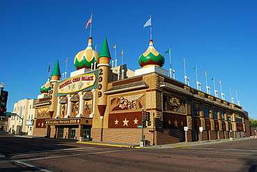
Corn Palace in Mitchell | |
 Location in Davison County and the state of South Dakota | |
 Mitchell, South Dakota Location in the United States | |
| Coordinates: 43°42′50″N 98°1′35″W / 43.71389°N 98.02639°WCoordinates: 43°42′50″N 98°1′35″W / 43.71389°N 98.02639°W | |
| Country | United States |
| State | South Dakota |
| County | Davison |
| Incorporated | 1883[1] |
| Government | |
| • Mayor | Jerry Toomey |
| Area[2] | |
| • Total | 12.14 sq mi (31.44 km2) |
| • Land | 11.14 sq mi (28.85 km2) |
| • Water | 1.00 sq mi (2.59 km2) |
| Elevation | 1,312 ft (400 m) |
| Population (2010)[3] | |
| • Total | 15,254 |
| • Estimate (2015)[4] | 15,669 |
| • Density | 1,369.3/sq mi (528.7/km2) |
| Time zone | Central (CST) (UTC-6) |
| • Summer (DST) | CDT (UTC-5) |
| ZIP code | 57301 |
| Area code(s) | 605 |
| FIPS code | 46-43100 |
| GNIS feature ID | 1256500[5] |
| Website | City of Mitchell |
Mitchell is a city in and the county seat of Davison County, South Dakota, United States.[6] The population was 15,254 at the 2010 census.
Mitchell is the principal city of the Mitchell Micropolitan Statistical Area, which includes all of Davison and Hanson counties.
History
The first settlement at Mitchell was made in 1879.[7] Mitchell was incorporated in 1883.[1] It was named for Milwaukee banker Alexander Mitchell, President of the Chicago, Milwaukee, and St. Paul Railroad (Milwaukee Road).[8]
Geography
Mitchell is located at 43°42′50″N 98°1′35″W / 43.71389°N 98.02639°W (43.713896, -98.026282),[9] on the James River.
According to the United States Census Bureau, the city has a total area of 12.14 square miles (31.44 km2), of which, 11.14 square miles (28.85 km2) is land and 1.00 square mile (2.59 km2) is water.[2]
Mitchell has been assigned the ZIP code 57301 and the FIPS place code 43100.
Climate
Mitchell has a humid continental climate, like much of the Midwestern United States, with cold, harsh, sometimes snowy winters, and hot, sometimes humid summers. Average daytime summer temperatures range from 86 °F (30 °C) during the day, and 62 °F (16 °C) during the night, and winter daytime temperatures average 26 °F (-3 °C) during the day, and 4 °F ( -15 °C) during the night. Most of the precipitation falls during the summer months, the wettest month being June, with an average of 3.52 inches (89.4 mm) of rain, and the driest month is January, with only 0.47 inches (11.9 mm) of rain. Mitchell is located in Tornado Alley, so thunderstorms, often spawning tornadoes, can be expected.
| Climate data for Mitchell, South Dakota | |||||||||||||
|---|---|---|---|---|---|---|---|---|---|---|---|---|---|
| Month | Jan | Feb | Mar | Apr | May | Jun | Jul | Aug | Sep | Oct | Nov | Dec | Year |
| Record high °F (°C) | 67 (19) |
73 (23) |
95 (35) |
97 (36) |
108 (42) |
111 (44) |
116 (47) |
115 (46) |
106 (41) |
96 (36) |
91 (33) |
70 (21) |
116 (47) |
| Average high °F (°C) | 26 (−3) |
33 (1) |
44 (7) |
59 (15) |
71 (22) |
81 (27) |
86 (30) |
85 (29) |
76 (24) |
62 (17) |
43 (6) |
30 (−1) |
58 (14.5) |
| Average low °F (°C) | 4 (−16) |
11 (−12) |
22 (−6) |
35 (2) |
47 (8) |
57 (14) |
62 (17) |
59 (15) |
48 (9) |
36 (2) |
22 (−6) |
10 (−12) |
34.4 (1.3) |
| Record low °F (°C) | −50 (−46) |
−49 (−45) |
−23 (−31) |
1 (−17) |
18 (−8) |
31 (−1) |
34 (1) |
34 (1) |
11 (−12) |
−8 (−22) |
−22 (−30) |
−34 (−37) |
−50 (−46) |
| Average precipitation inches (mm) | 0.469 (11.9) |
0.669 (17.0) |
1.657 (42.1) |
2.709 (68.8) |
3.327 (84.5) |
3.52 (89.4) |
2.64 (67) |
2.319 (58.9) |
2.268 (57.6) |
1.539 (39.1) |
1.197 (30.4) |
0.528 (13.4) |
22.842 (580.1) |
| Source: http://www.weather.com/weather/wxclimatology/monthly/graph/USSD0226 | |||||||||||||
Demographics
| Historical population | |||
|---|---|---|---|
| Census | Pop. | %± | |
| 1880 | 320 | — | |
| 1890 | 2,217 | 592.8% | |
| 1900 | 4,055 | 82.9% | |
| 1910 | 6,515 | 60.7% | |
| 1920 | 8,478 | 30.1% | |
| 1930 | 10,942 | 29.1% | |
| 1940 | 10,633 | −2.8% | |
| 1950 | 12,123 | 14.0% | |
| 1960 | 12,555 | 3.6% | |
| 1970 | 13,425 | 6.9% | |
| 1980 | 13,916 | 3.7% | |
| 1990 | 13,798 | −0.8% | |
| 2000 | 14,558 | 5.5% | |
| 2010 | 15,254 | 4.8% | |
| Est. 2015 | 15,669 | [10] | 2.7% |
| U.S. Decennial Census[11] 2015 Estimate[4] | |||
The campus of Dakota Wesleyan University is located in southwest Mitchell.
2010 census
As of the census[3] of 2010, there were 15,254 people, 6,696 households, and 3,641 families residing in the city. The population density was 1,369.3 inhabitants per square mile (528.7/km2). There were 7,120 housing units at an average density of 639.1 per square mile (246.8/km2). The racial makeup of the city was 93.6% White, 0.5% African American, 3.0% Native American, 0.5% Asian, 0.1% Pacific Islander, 0.6% from other races, and 1.8% from two or more races. Hispanic or Latino of any race were 1.7% of the population.
There were 6,696 households of which 26.4% had children under the age of 18 living with them, 41.1% were married couples living together, 9.5% had a female householder with no husband present, 3.7% had a male householder with no wife present, and 45.6% were non-families. 38.3% of all households were made up of individuals and 15.7% had someone living alone who was 65 years of age or older. The average household size was 2.16 and the average family size was 2.88.
The median age in the city was 36.8 years. 22.6% of residents were under the age of 18; 12.5% were between the ages of 18 and 24; 22.8% were from 25 to 44; 23.9% were from 45 to 64; and 18.2% were 65 years of age or older. The gender makeup of the city was 48.8% male and 51.2% female.
2000 census
As of the census of 2000, there were 14,558 people, 6,121 households, and 3,599 families residing in the city. The population density was 1,475.7 people per square mile (569.5/km²). There were 6,555 housing units at an average density of 664.4 per square mile (256.4/km²). The racial makeup of the city was 95.63% White, 0.32% African American, 2.40% Native American, 0.45% Asian, 0.03% Pacific Islander, 0.29% from other races, and 0.87% from two or more races. Hispanic or Latino of any race were 0.77% of the population.
There were 6,121 households out of which 28.9% had children under the age of 18 living with them, 46.6% were married couples living together, 9.1% had a female householder with no husband present, and 41.2% were non-families. 34.3% of all households were made up of individuals and 15.0% had someone living alone who was 65 years of age or older. The average household size was 2.27 and the average family size was 2.95.
In the city the population was spread out with 24.1% under the age of 18, 13.4% from 18 to 24, 25.3% from 25 to 44, 19.6% from 45 to 64, and 17.6% who were 65 years of age or older. The median age was 36 years. For every 100 females there were 91.9 males. For every 100 females age 18 and over, there were 89.4 males.
As of 2000 the median income for a household in the city was $31,308, and the median income for a family was $43,095. Males had a median income of $30,881 versus $20,794 for females. The per capita income for the city was $17,888. About 8.8% of families and 12.8% of the population were below the poverty line, including 12.7% of those under age 18 and 10.9% of those age 65 or over.

Attractions
Mitchell is home of the Corn Palace. The Corn Palace is decorated with several colors of dried corn and grains, creating murals. The theme of the external murals is changed yearly at fall harvest; internal murals are changed approximately every ten years. The building itself is used for several purposes including a basketball arena, the local high school prom, trade shows, staged entertainment, and the Shriner's Circus.
Mitchell is also the home of the Dakota Discovery Museum, whose mission is to present and preserve the history of the prairie and the people who settled it. The museum covers the time period from 1600, when the Native Americans were still largely undiscovered, to 1939, the end of the Great Depression. The museum holds one of the most complete and pristine collections of American Indian quill and bead-works. The Dakota Discovery Museum also features artists such as Harvey Dunn, James Earle Fraser, Charles Hargens and Oscar Howe. In the village area behind the main building are four authentic historical buildings, including an 1885 one-room school house and the fully furnished 1886 Victorian-Italianate home of the co-founder of the Corn Palace, Louis Beckwith. Two new features of the museum are Discovery Land, a hands-on activity area for children ages five to ten, and the Heritage Gardens Project, which brings indigenous plants to the gardens surrounding the museum and historical buildings.
The Mitchell Prehistoric Indian Village, an archaeological site where scientists are excavating a Native American village, is another attraction in the city. The site, near Lake Mitchell, is believed to have been occupied by ancestors of the present-day Mandan, who now reside in North Dakota. The excavation is unique in that it is enclosed by an Archeodome, a climate-controlled building built over the site, which allows scientists to continue their excavation work year-round.
The Mitchell area also boasts several state champion trees: Black Cherry, Black Locust, Siberian Elm, and Tulip Tree.[12]
Sports
The South Dakota Gold was a professional basketball club that competed in the International Basketball Association in the 2000-01 season.
Media
AM Radio
| AM radio stations | |||||
|---|---|---|---|---|---|
| Frequency | Call sign | Name | Format | Owner | City |
| 1490 AM | KORN | KORN News Radio 1490 | News/Talk/Sports | Riverfront Broadcasting LLC | Mitchell |
FM Radio
| FM radio stations | ||||||
|---|---|---|---|---|---|---|
| Frequency | Call sign | Name | Format | Owner | Target city/market | City of license |
| 89.7 FM | K209FX | K-Love | Contemporary Christian | Educational Media Foundation | Mitchell | Mitchell |
| 90.9 FM | K215AI | South Dakota Public Broadcasting | NPR | SD Board of Directors for Educational Telecommunications | Mitchell | Mitchell |
| 92.1 FM | KORN-FM | KORN Country 92.1 | Mainstream Country | Riverfront Broadcasting LLC | Mitchell | Mitchell |
| 93.3 FM | KJRV | Big Jim 93.3 | Classic Rock | Dakota Communications | Huron/Mitchell | Wessington Springs |
| 95.5 FM | K238BA | More 95.5 | AC | Saga Communications of South Dakota, LLC | Mitchell | Mitchell |
| 98.3 FM | KUQL | Kool 98.3 | Oldies | Saga Communications of South Dakota, LLC | Mitchell | Wessington Springs |
| 103.5 FM | K238BA | More 95.5 | AC | Saga Communications of South Dakota, LLC | Mitchell | Mitchell |
| 105.9 FM | KMIT | Hot Country KMIT | Country | Saga Communications of South Dakota, LLC | Mitchell | Mitchell |
| 107.3 FM | KQRN | Q107.3 | Adult hits, and Top 40 Rock and Pop Hits | Riverfront Broadcasting LLC | Mitchell | Mitchell |
Notable people

- Ordell Braase, former NFL player and broadcaster
- Israel Greene, adjutant of the Confederate Marine Corps
- James S. Hyde, biophysicist
- John Bailey Jones, retired United States federal judge
- Michael (Mike) Lloyd Miller was born and raised in Mitchell and is an American professional basketball player, was 2000-01 NBA Rookie of the Year, 2005–06 NBA Sixth Man of the Year Award winner, a two-time NBA champion with the Miami Heat, and is currently a member of the NBA's Denver Nuggets.
- George McGovern, former Representative and Senator from South Dakota and 1972 Democratic nominee for President, grew up in Mitchell, and lived there until his death in 2012.
- Adam Morrison, current basketball player for the Charlotte Bobcats, briefly lived in Mitchell as a young child while his father was coaching at Dakota Wesleyan.
- Gary Owens, voice actor and Disc Jockey
- Howard Rushmore, journalist and investigative reporter
References
- 1 2 "SD Towns" (PDF). South Dakota State Historical Society. Retrieved 2010-02-14.
- 1 2 "US Gazetteer files 2010". United States Census Bureau. Retrieved 2012-06-21.
- 1 2 "American FactFinder". United States Census Bureau. Retrieved 2012-06-21.
- 1 2 "Population Estimates". United States Census Bureau. Retrieved June 7, 2016.
- ↑ "US Board on Geographic Names". United States Geological Survey. 2007-10-25. Retrieved 2008-01-31.
- ↑ "Find a County". National Association of Counties. Retrieved 2011-06-07.
- ↑ Federal Writers' Project (1940). South Dakota place-names, v.1-3. University of South Dakota. p. 50.
- ↑ Chicago and North Western Railway Company (1908). A History of the Origin of the Place Names Connected with the Chicago & North Western and Chicago, St. Paul, Minneapolis & Omaha Railways. p. 184.
- ↑ "US Gazetteer files: 2010, 2000, and 1990". United States Census Bureau. 2011-02-12. Retrieved 2011-04-23.
- ↑ "Annual Estimates of the Resident Population for Incorporated Places: April 1, 2010 to July 1, 2015". Retrieved July 2, 2016.
- ↑ United States Census Bureau. "Census of Population and Housing". Retrieved September 23, 2013.
- ↑ South Dakota Register of Big Trees
External links
| Wikivoyage has a travel guide for Mitchell (South Dakota). |
- Mitchell, SD government website
- Mitchell Daily Republic - Local newspaper
- Vintage Postcards of Mitchell
Municipalities and communities of Davison County, South Dakota, United States | ||
|---|---|---|
| City | 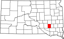 | |
| Town | ||
| CDP | ||