Oswego, Montana
| Oswego, Montana | |
|---|---|
| Unincorporated community | |
 Oswego, Montana Location within the state of Montana | |
| Coordinates: 48°3′31″N 105°52′50″W / 48.05861°N 105.88056°WCoordinates: 48°3′31″N 105°52′50″W / 48.05861°N 105.88056°W | |
| Country | United States |
| State | Montana |
| County | Valley |
| Time zone | Mountain (MST) (UTC-7) |
| • Summer (DST) | MDT (UTC-6) |
Oswego /ɒsˈwiːɡoʊ/ is an unincorporated community in Valley County, Montana, United States. It is located along U.S. Route 2 between the cities of Frazer and Wolf Point. Oswego is located on the Fort Peck Indiean Reservation.
History
Settled sometime in the 1890s, the village was named after Oswego, New York, the hometown of some early-day settlers.[1] A post office was located there from 1896 until 1971. In 1971 one of the worst prairie fires in northeastern Montana destroyed much of Oswego, leaving only 4 homes untouched. The entire population of Oswego was forced to evacuate, and of those 75 residents only about 40 of them returned to live and rebuild.
References
- ↑ Compiled and Written by the Federal Writers' Project of the Work Projects Administration for the State of Montana (1939). "Oswego, Montana". Montana: A State Guide Book. Retrieved 2007-01-27.
External links
Municipalities and communities of Valley County, Montana, United States | ||
|---|---|---|
| City | 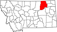 | |
| Towns | ||
| CDPs | ||
| Unincorporated communities | ||
| Indian reservation | ||
| Ghost towns | ||
| Footnotes | ‡This populated place also has portions in an adjacent county or counties | |
This article is issued from Wikipedia - version of the 12/31/2014. The text is available under the Creative Commons Attribution/Share Alike but additional terms may apply for the media files.