Nelson, North Carolina
| Nelson, North Carolina | |
|---|---|
| Unincorporated community | |
 Nelson Location within the state of North Carolina | |
| Coordinates: 35°52′55″N 78°51′0″W / 35.88194°N 78.85000°WCoordinates: 35°52′55″N 78°51′0″W / 35.88194°N 78.85000°W | |
| Country | United States |
| State | North Carolina |
| County | Durham |
| Time zone | Eastern (EST) (UTC-5) |
| • Summer (DST) | EDT (UTC-4) |
Nelson was a small southern town in Durham County, North Carolina. The community was centered at the intersection of Miami Boulevard and North Carolina Highway 54. It was largely a farming community with several tobacco and livestock farms as well as a tight knit family oriented community. Though still on the map, it is all but erased by the growth surrounding the Research Triangle Park. All of the farms have been paved over and old farmhouses and barns torn down to acccomdate the huge corporations and other business entities you will see if you drive through the area. A few of the older small homes are still there, as well as the Cedar Fork Baptist church, but the community itself essentially no longer exists.
Municipalities and communities of Durham County, North Carolina, United States | ||
|---|---|---|
| Cities | 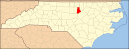 | |
| Towns | ||
| CDPs | ||
| Unincorporated communities | ||
| Footnotes | ‡This populated place also has portions in an adjacent county or counties | |